Ebbsfleet, Thanet

Last updated

Ebbsfleet
Frosty Towers - geograph.org.uk - 332068.jpg
Farmland at Ebbsfleet, with Richborough Power Station in the distance (prior to the demolition of the cooling towers in 2012)
Kent UK location map.svg
Red pog.svg
Ebbsfleet
Location within Kent
OS grid reference TR333631
Civil parish
District
Shire county
Region
Country England
Sovereign state United Kingdom
Post town RAMSGATE
Postcode district CT12
Police Kent
Fire Kent
Ambulance South East Coast
UK Parliament
List of places
UK
England
Kent
51°18′54″N1°21′00″E / 51.315°N 1.350°E / 51.315; 1.350

Ebbsfleet is a hamlet near Ramsgate, Kent, at the head of Pegwell Bay. Historically it was a peninsula on the southern coast of the Isle of Thanet, marking the eastern end of the Wantsum Channel that separated Thanet from the Kentish mainland. It is in the civil parish of Minster-in-Thanet.

Contents

Pegwell Bay is a natural harbour on the part of the coast nearest to the Continent, and consequently, Ebbsfleet is associated with two important arrivals in English history: Hengist and Horsa in 449 AD, said to have led the Anglo-Saxons in their conquest of Britain; and Augustine of Canterbury in 597 AD, who converted much of England to Christianity.

Ebbsfleet is the titular see of the Bishop of Ebbsfleet, an episcopal visitor for the Province of Canterbury.

Geography

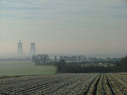
Ebbsfleet Lane marks the line of the peninsula today. The Wantsum Channel silted up and was reclaimed in the 15th century; all that remains of it is the channel of the River Stour, which enters the sea by Richborough Power Station. There are a couple of houses and Ebbsfleet House at Stonelees, where Ebbsfleet Lane meets the Sandwich road, and Ebbsfleet Farm on the hill behind.

History

There are prehistoric, Iron Age, Roman, and Saxon settlement remains on the peninsula around Ebbsfleet Farm, which may have also been the landing stage for the Roman ferry across the channel to Richborough. Archaeologists suggest that Pegwell Bay was the site of both Roman invasions of Britain. [1] Claudius landed his army at Richborough on the other side of the channel, to start his invasion of 43 AD, and it became a major port of Roman Britain.

According to the Anglo-Saxon Chronicle it is also the site of the landings made by the Saxons in the fifth century AD; an entry states that Hengist and Horsa, on the invitation of Vortigern, King of the Britons, landed in 449 at Eopwinesfleot, usually assumed to be Ebbsfleet. [2] A fleot is a creek and Eopwine is a Germanic personal name; the modern Ebbsfleet may have developed from Eoppa/Eobba, a short form of this name. [3] The arrival of the Saxons is commemorated by a monument and replica longship up the coast at Cliffsend. The Battle of Wippedesfleot between the Britons and the English in 465 is thought to have taken place at Ebbsfleet.

Bede wrote in his Ecclesiastical History : "On the east of Kent is the large Isle of Thanet containing, according to the English way of reckoning, 600 families, divided from the other land by the river Wantsum, which is about three furlongs over, and fordable only in two places, for both ends of it run into the sea. In this island landed the servant of our Lord, Augustine, and his companions, being, as is reported, nearly forty men. They had, by order of the blessed Pope Gregory, taken interpreters of the nation of the Franks."

This has been interpreted to mean Ebbsfleet was where Augustine landed. In 1884, St Augustine's Cross was erected on the lane between Cliffsend and Sevenscore to commemorate his first sermon in Kent. [4]

Energy

Richborough Power Station to the south was operational from 1962 to 1996; the towers were demolished in 2012. The power lines are being reused for the Thanet Wind Farm in the sea off Broadstairs.

Ebbsfleet Solar Farm is on the site of the former Richborough Power Station. It has a capacity of 4.9 MWp and became operational in 2011. [5] The solar farm is part of a larger ongoing project, Richborough Energy Park.

Archaeology

The site of Julius Caesar's landing in Britain on 4 July 54 BC had been a source of dispute. It was assumed that a fort would have been built to protect the landing, and none had been found. On 29 November 2017, archaeologists from the University of Leicester announced that during the excavation they had done at Ebbsfleet, fortifications had been found. [6]

Notes

  1. Sample, Ian (29 November 2017). "Caesar's invasion of Britain began from Pegwell Bay in Kent, say archaeologists". The Guardian. Archived from the original on 29 November 2017. Retrieved 29 November 2017.
  2. Keith Briggs, The two Ebbsfleets in Kent. Journal of the English Place-Name Society 44, 5–9
  3. McClure, Edmund (1910). British Place-Names in their Historical Setting. The Society for Promoting Christian Knowledge. pp.  132–3.
  4. Date and text of the inscription Archived 1 May 2007 at the Wayback Machine .
  5. "Ebbsfleet Solar Farm". Archived from the original on 23 January 2021. Retrieved 27 May 2012.
  6. "First evidence for Julius Caesar's invasion of Britain discovered — University of Leicester". www2.le.ac.uk. Archived from the original on 29 November 2017. Retrieved 29 November 2017.

Related Research Articles

<span class="mw-page-title-main">Hengist and Horsa</span> Legendary brothers said to have led the invasion of Britain in the 5th century

Hengist and Horsa are Germanic brothers said to have led the Angles, Saxons and Jutes in their invasion of Britain in the 5th century. Tradition lists Hengist as the first of the Jutish kings of Kent.

<span class="mw-page-title-main">River Stour, Kent</span> River in England

The River Stour(, rhymes with "flour") is a river in Kent, England that flows into the North Sea at Pegwell Bay. Above Plucks Gutter, where the Little Stour joins it, the river is normally known as the Great Stour. The upper section of the river, above its confluence with the East Stour at Ashford is sometimes known as the Upper Great Stour or West Stour. In the tidal lower reaches, the artificial Stonar Cut short cuts a large loop in the natural river.

<span class="mw-page-title-main">Minster-in-Thanet</span> Human settlement in England

Minster, also known as Minster-in-Thanet, is a village and civil parish in the Thanet District of Kent, England. It is the site of Minster in Thanet Priory. The village is west of Ramsgate and to the north east of Canterbury; it lies just south west of Kent International Airport and just north of the River Stour. Minster is also the "ancient capital of Thanet". At the 2011 Census the hamlet of Ebbsfleet was included.

<span class="mw-page-title-main">Isle of Thanet</span> Peninsula in Kent, England

The Isle of Thanet is a peninsula forming the easternmost part of Kent, England. While in the past it was separated from the mainland by the 600-metre-wide (2,000 ft) Wantsum Channel, it is no longer an island.

<span class="mw-page-title-main">Kingdom of Kent</span> Early medieval kingdom in England (c.455-871)

The Kingdom of the Kentish, today referred to as the Kingdom of Kent, was an early medieval kingdom in what is now South East England. It existed from either the fifth or the sixth century AD until it was fully absorbed into the Kingdom of Wessex in the late 9th century and later into the Kingdom of England in the early 10th century.

<span class="mw-page-title-main">St Nicholas-at-Wade</span> Human settlement in England

St Nicholas-at-Wade is both a village and a civil parish in the Thanet District of Kent, England. The parish had a recorded population of 782 at the 2001 Census, increasing to 852 at the 2011 census. The village of Sarre is part of the civil parish.

The Wantsum Channel was a strait separating the Isle of Thanet from the north-eastern extremity of the English county of Kent and connecting the English Channel and the Thames Estuary. It was a major shipping route when Britain was part of the Roman Empire, and continued in use until it was closed by silting in the late Middle Ages. Its course is now represented by the River Stour and the River Wantsum, which is little more than a drainage ditch lying between Reculver and St Nicholas-at-Wade and joins the Stour about 1.7 miles (2.7 km) south-east of Sarre.

<span class="mw-page-title-main">Richborough</span> Harbour in Kent, England

Richborough is a settlement north of Sandwich on the east coast of the county of Kent, England. Richborough lies close to the Isle of Thanet. The population of the settlement is included in the civil parish of Ash.

<span class="mw-page-title-main">Site of the Claudian invasion of Britain</span> Historical location, subject of debate

The site of the Claudian invasion of Britain in AD 43 has been a matter of academic debate. Although it is generally believed that the force left from Gesoriacum (Boulogne), it is possible that part of the fleet sailed from near the mouth of the Rhine. Rutupiæ has earthworks that defended a bridgehead dating from this period and is often stated as the site of the landing, though there are plausible arguments in favour of a landing further west along the south coast of Britain.

<span class="mw-page-title-main">Richborough Castle</span> Ancient fort in Kent, England

Richborough Castle is a Roman Saxon Shore fort better known as Richborough Roman Fort. It is situated in Richborough near Sandwich, Kent. Substantial remains of the massive fort walls still stand to a height of several metres.

<span class="mw-page-title-main">Pegwell Bay</span>

Pegwell Bay is a shallow inlet in the English Channel coast astride the estuary of the River Stour north of Sandwich Bay, between Ramsgate and Sandwich in Kent. Part of the bay is a nature reserve, with seashore habitats including mudflats and salt marsh with migrating waders and wildfowl. The public can access the nature reserve via Pegwell Bay Country Park, which is off the A256 Ramsgate to Dover road.

<span class="mw-page-title-main">Saxon Shore Way</span> Long-distance footpath in England

The Saxon Shore Way is a long-distance footpath in England. It starts at Gravesend, Kent, and traces the coast of South-East England as it was in Roman times as far as Hastings, East Sussex, 163 miles (262 km) in total. This means that around Romney Marsh the route runs significantly inland from the modern coastline.

<span class="mw-page-title-main">Julius Caesar's invasions of Britain</span> Military campaigns in 55 and 54 BC

In the course of his Gallic Wars, Julius Caesar invaded Britain twice: in 55 and 54 BC. On the first occasion Caesar took with him only two legions, and achieved little beyond a landing on the coast of Kent. The second invasion consisted of 628 ships, five legions and 2,000 cavalry. The force was so imposing that the Britons did not dare contest Caesar's landing in Kent, waiting instead until he began to move inland. Caesar eventually penetrated into Middlesex and crossed the Thames, forcing the British warlord Cassivellaunus to surrender as a tributary to Rome and setting up Mandubracius of the Trinovantes as client king.

<span class="mw-page-title-main">Cliffsend</span> Human settlement in England

Cliffsend is a village and civil parish situated almost 2 miles (3 km) west of Ramsgate, Kent, United Kingdom, in the Thanet local government district.

<span class="mw-page-title-main">White Horse of Kent</span> Symbol of Kent, England

The white horse of Kent, known colloquially as the white horse rampant, is a symbol of the county of Kent, in south-east England. The heraldic image is correctly blazoned as Gules, a stallion forcené argent.

Events from the 5th century in England.

<span class="mw-page-title-main">Regulbium</span> Roman fort in Kent, England

Regulbium was the name of an ancient Roman fort of the Saxon Shore in the vicinity of the modern English resort of Reculver in Kent. Its name derives from the local Brythonic language, meaning "great headland" (*Rogulbion).

<span class="mw-page-title-main">Hugin (longship)</span>

The Hugin is a reconstructed longship located at Pegwell Bay in Kent, England. It was a gift from the Danish government commemorating the 1500th anniversary of the arrival of Hengist and Horsa, leaders of the Anglo-Saxon invasion, at nearby Ebbsfleet. The ship is a replica of the much later ca. 890 Gokstad ship.

<span class="mw-page-title-main">St Augustine's Cross</span> Stone memorial in Kent, England