Sevington

Last updated

Sevington
Sevington DSC 6721.jpg
St Mary's Church, Sevington
Kent UK location map.svg
Red pog.svg
Sevington
Location within Kent
Area0.76 km2 (0.29 sq mi)
Population310 (Civil Parish 2011) [1]
  Density 408/km2 (1,060/sq mi)
OS grid reference TR0340
Civil parish
District
Shire county
Region
Country England
Sovereign state United Kingdom
Post town Ashford
Postcode district TN24
Dialling code 01233
Police Kent
Fire Kent
Ambulance South East Coast
UK Parliament
List of places
UK
England
Kent
51°07′41″N0°54′29″E / 51.128°N 0.908°E / 51.128; 0.908

Sevington is a village in the civil parish of Sevington with Finberry, in the Ashford district, in Kent, England.

Contents

History

The geographically small village of Sevington is first recorded in the Domesday Book of 1086, where it appears as Seivetone. It appears as Seyueton in the Feet of Fines for 1314. The name means "the town or settlement of Sægifu", Sægifu being a woman's name. [2]

In 1872, the village had a population of about 113. [3]

St Mary's Church is the village's Norman parish church. It is a Grade I listed building dating from the 12th century, and has been altered at several times, first around 1200 and a second time in the 14th century, and underwent restoration in 1877 and 1936. The church is cut off from the village by the building of the Southern Orbital road. [4] [5]

Geography and economy

Sevington on the Southeastern Main Line. 395028 at Sevington (1).jpg
Sevington on the Southeastern Main Line.

Much of Sevington's small tract of land is covered by Ashford business park areas which are connected with Ashford by post town status and by its road network, linking them closely with Ashford.

At the start of the 21st century many changes took place in Sevington due to the building of the Orbital Business Park including the Ashford livestock market.

The village/suburb of Willesborough bounds Sevington (along its long north-west border), while the new Finberry neighbourhood is to the south in Mersham but with its own amenities. High Speed 1, the Channel Tunnel Rail Link which adjoins the ordinary railway, passes through the parish.

Customs clearance facility

In 2019, a 11-hectare (27-acre) tract of former farmland at Sevington was put up for sale for property development. Located close to Junction 10A of the M20 motorway, it was marketed as MOJO, an acronym for M20, Junction 10a), [6] In July 2020, the UK Government announced that it had acquired the MOJO site to develop it as a customs clearance facility for inbound freight and a holding area for outbound freight, in preparation for the withdrawal of the United Kingdom from the European Union. The site was selected due to its proximity to the Port of Dover. [7] [8] The facility has been nicknamed in the media as "the Farage Garage", in reference to the politician Nigel Farage, who has been one of the leading campaigners for Brexit. [9] Commentators in the media have noted that the 13th-century Church of St Mary will be surrounded by the planned lorry park. [10]

As at mid-December 2020, it is forecast to be finished by late February 2021. Although originally intended to be finished by 1 January 2021, heavy rain delayed construction; as a result, the site will temporarily only be used as a holding area, with customs checks being performed in Waterbrook Park nearby. [11]

As of January 2023, the facility is complete but not in any significant use. The Government has repeatedly postponed introduction of import controls, with (at the time) no firm plans to begin such. [12] In July 2023, the Government announced that application of controls on all goods arriving from the EU that are subject to sanitary and phytosanitary (SPS) controls, would begin in autumn 2023. [13]

Related Research Articles

<span class="mw-page-title-main">Kent</span> County of England

Kent is a ceremonial county in the South East England region, the closest county to continental Europe. It borders Essex across the entire estuary of the River Thames to the north; the French department of Pas-de-Calais across the Strait of Dover to the south-east; East Sussex to the south-west; Surrey to the west and Greater London to the north-west. The county town is Maidstone.

<span class="mw-page-title-main">Folkestone</span> Town in Kent, England

Folkestone is a port town on the English Channel, in Kent, south-east England. The town lies on the southern edge of the North Downs at a valley between two cliffs. It was an important harbour and shipping port for most of the 19th and 20th centuries.

<span class="mw-page-title-main">M20 motorway</span> Motorway in Kent, England

The M20 is a motorway in Kent, England. It follows on from the A20 at Swanley, meeting the M25, and continuing on to Folkestone, providing a link to the Channel Tunnel and the ports at Dover. It is 50.6 miles (81.4 km) long. Although not signposted in England, this road is part of the European route E15. It is also used as a holding area for goods traffic when traffic across the English Channel is disrupted, such as Operation Stack and Operation Brock.

<span class="mw-page-title-main">Ashford, Kent</span> Human settlement in England

Ashford is a town in the Ashford district, in the county of Kent, England. It lies on the River Great Stour at the southern or scarp edge of the North Downs, about 61 miles (98 km) southeast of central London and 15.3 miles (24.6 km) northwest of Folkestone by road. At the 2021 census, it had a population of 76,405. The name comes from the Old English æscet, indicating a ford near a clump of ash trees. It has been a market town since the Middle Ages, and a regular market continues to be held.
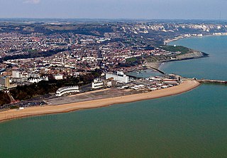
<span class="mw-page-title-main">Nigel Farage</span> British broadcaster and former politician (born 1964)

Nigel Paul Farage is a British broadcaster and former politician who was Leader of the UK Independence Party (UKIP) from 2006 to 2009 and 2010 to 2016 and Leader of the Brexit Party from 2019 to 2021. He served as Member of the European Parliament (MEP) for South East England from 1999 until the United Kingdom's exit from the European Union in 2020. He was the host of The Nigel Farage Show, a radio phone-in on the Global-owned talk radio station LBC, from 2017 to 2020. Farage is currently the Honorary President of Reform UK and a presenter for GB News.

<span class="mw-page-title-main">Borough of Ashford</span> Place in England

The Borough of Ashford is a local government district with borough status in Kent, England. It borders five other Kent districts, as well as East Sussex to the south-west. Ashford Borough Council's main offices are in the town of Ashford. The borough was formed on 1 April 1974, by the merger of the then Borough of Tenterden with Ashford urban district as well as the Rural Districts of East Ashford, West Ashford and Tenterden. Covering 58,000 hectares, it is the largest district by area in Kent.

<span class="mw-page-title-main">Rosslare Europort</span> Port in Rosslare Harbour, County Wexford, Ireland

Rosslare Europort is a modern seaport located at Rosslare Harbour in County Wexford, Ireland, near the southeasternmost point of the island of Ireland. The port is the premier Irish port serving the European Continent with 36 direct services to the Continent weekly. It handles passenger and freight ferries to and from Cherbourg, Dunkirk and St Malo/Roscoff, in France, Bilbao in Spain and Fishguard and Pembroke Dock in the United Kingdom. Since July 2022, a new freight route between Rosslare and Zeebrugge, Belgium was introduced by Finnlines for a twice weekly ro-ro service between the two ports.

<span class="mw-page-title-main">Arnside</span> Human settlement in England

Arnside is a village and civil parish in Cumbria, historically part of Westmorland, near the border with Lancashire, England. The Lake District National Park is located a few miles north. Travelling by road, Arnside is 22 miles (35 km) to the south of Kendal, 25.3 miles (40.7 km) to the east of Ulverston, 35.2 miles (56.6 km) to the east of Barrow-in-Furness, 15.7 miles (25.3 km) to the west of Lancaster and 14.3 miles (23.0 km) to the east of Grange-over-Sands. In the 2001 census the parish had a population of 2,301, increasing at the 2011 census to 2,334.

Appledore is a village and civil parish in the Ashford District of Kent, England. The village centre is on the northern edge of the Romney Marsh, 12 miles (19 km) south-west of Ashford town. The northerly part of this village is Appledore Heath.

<span class="mw-page-title-main">Farnborough, London</span> Human settlement in England

Farnborough is a village in south-eastern Greater London, England, and prior to 1965, in the historic county of Kent. Situated south of Locksbottom, west of Green Street Green, north of Downe and Hazelwood, and east of Keston, it is centred 13.4 miles (21.6 km) southeast of Charing Cross.

Willesborough is a village, now in effect a residential suburb, on the eastern side of Ashford, Kent, England.

<span class="mw-page-title-main">Operation Stack</span> Contingency plan for traffic congestion in Kent

Operation Stack is a procedure used by Kent Police and the Port of Dover in England to park lorries on the M20 motorway in Kent when services across the English Channel, such as those through the Channel Tunnel or from the Port of Dover, are disrupted, for example by bad weather, industrial action, fire or derailments in the tunnel.

<span class="mw-page-title-main">Mersham</span> Human settlement in England

Mersham is a mostly agricultural large village and civil parish near Ashford in Kent, England. The population of the civil parish includes the area of Cheesman's Green now known as Finberry.
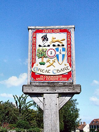
<span class="mw-page-title-main">Northiam</span> Village in East Sussex, England

Northiam is a village and civil parish in the Rother district, in East Sussex, England, 13 miles (21 km) north of Hastings in the valley of the River Rother. The A28 road to Canterbury and Hastings passes through it.

<span class="mw-page-title-main">Kingsnorth</span> Human settlement in England

Kingsnorth is a village and civil parish in the Borough of Ashford in Kent, England. The civil parish adjoins the town of Ashford.

Sellindge is a civil parish and village on the A20 road between Ashford and Folkestone in Kent, South East England. Sellindge is part of North Downs West Ward of Folkestone and Hythe District Council but part of the Elham ward of Kent County Council.

<span class="mw-page-title-main">Staplehurst</span> Human settlement in England

Staplehurst is a town and civil parish in the borough of Maidstone in Kent, England, 9 miles (14 km) south of the town of Maidstone and with a population of 6,003. The village lies on the route of a Roman road, which is now incorporated into the course of the A229. The name Staplehurst comes from the Old English 'stapol' meaning a 'post, pillar' and 'hyrst', as a 'wooded hill'; therefore, 'wooded-hill at a post', a possible reference to a boundary marker at the position of All Saints' church atop the hill along the road from Maidstone to Cranbrook. The parish includes the hamlet of Hawkenbury.

<span class="mw-page-title-main">Finberry</span> Human settlement in England

Finberry is a housing estate located in the south-east of Ashford, in the civil parish of Sevington with Finberry, in the Ashford district, in the county of England. The population of the housing estate is included in the civil parish of Mersham. The nearest existing places to the housing estate are Sevington to the north, Willesborough to the north-west, and Park Farm. The housing estate was opened by the Mayor of Ashford in June 2014. Finberry Primary School opened 2017.

<span class="mw-page-title-main">Operation Brock</span> Traffic management system to mitigate the effects of Brexit

Operation Brock is the traffic management system in Kent, England, used to supplement Operation Stack during cross-Channel traffic problems. It was originally developed for use in the event of a no-deal Brexit and the name is derived from Brexit Operations across Kent.

References

  1. Key Statistics; Quick Statistics: Population Density United Kingdom Census 2011 Office for National Statistics Retrieved 10 May 2014
  2. Eilert Ekwall, The Concise Oxford Dictionary of English Place-names, p.413.
  3. Imperial Gazetteer of England and Wales, John Marius Wilson (1872).
  4. Historic England. "CHURCH OF ST MARY, Sevington (1233902)". National Heritage List for England . Retrieved 17 December 2020.
  5. KentParishes.gov.uk
  6. "Up to 1.2m SQ FT Development opportunity | Mojo Kent". Mojo. Aviva Investors. July 2019. Archived from the original on 28 November 2020. Retrieved 15 December 2020.
  7. Lisa O'Carroll (10 July 2020). "Vast Brexit customs clearance centre to be built in Kent". The Guardian. Retrieved 8 August 2020.
  8. Lisa O'Carroll (16 July 2020). "Kent customs facility will also be used as lorry park, minister confirms". The Guardian. Retrieved 8 August 2020.
  9. "Near U.K.'s Busiest Port, Brexit Hopes Are Layered in Asphalt". New York Times. 8 August 2020. Retrieved 8 August 2020.
  10. "The 13th-century church set to be surrounded by a 27-acre Brexit lorry park". Metro. 8 December 2020. Archived from the original on 11 December 2020. Retrieved 15 December 2020.
  11. "Brexit lorry park won't be complete until February". 14 December 2020.
  12. Helm, Toby (21 January 2023). "'It's a farce': the giant Brexit border control site now used to inspect Ukrainian pets". The Observer.
  13. Partridge, Joanna (14 July 2023). "Brexit import controls: is the UK ready and will they push up prices?". The Guardian. the government's proposals for its new post-Brexit border strategy beginning this autumn will require all goods arriving from the EU that are subject to sanitary and phytosanitary (SPS) controls  including fruit, vegetables, meat, dairy and plant  to pass through ports or government-operated facilities such as its new inland border control post at Sevington in Kent.

Commons-logo.svg Media related to Sevington at Wikimedia Commons