Mersham is a mostly agricultural large village and civil parish near Ashford in Kent, England. The population of the civil parish includes the area of Cheesman's Green now known as Finberry.
The village stands adjacent to the Tunbridge and Dover railway, 1½ mile NNW of Smeeth r. station, and 3½ SE of Ashford; and has a post office under Ashford and a fair on WhitFriday. The parish comprises 2,675 acres. Pop., 752. Houses, 143. The property is much subdivided.
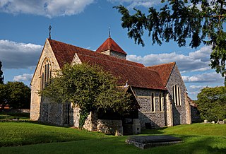
Mersham Hatch is the seat of Sir N. J. Knatchbull, Bart.; has belonged to his family since the time of Henry VIII.; and is a red brick mansion, rebuilt in the last century. The living is a rectory in the diocese of Canterbury. Value, £632.[lower-alpha 1] Patron, Oriel College, Oxford. The church is ancient but good; comprises nave, aisles, and two chancels; and contains monuments of the Hatch family. There are an endowed school with £10 a year,[lower-alpha 2] and charities £61.[2][lower-alpha 3]
Until the early 20th century Mersham was for its majority a farming and orchard-tending community with close ties to the local market town of Ashford. The small village dates back to Saxon times and is mentioned in the Domesday Book. The village was owned by the Archbishops of Canterbury for over 500years. The Anglican church is dedicated to St. John the Baptist and is in the highest category of listed building, at Grade I.[3] It stands on the site of a Saxon church, and is part Norman. It is thought that the village gives rise to the surname Marshman.[citation needed]
The Knatchbulls
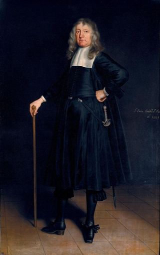
The village has been the home of the Knatchbull family since the times of Henry VIII. In 1638 Sir Norton Knatchbull founded Ashford Grammar School, to which pupils were not admitted until they could read the Bible in English, he was also the Member of Parliament for Romney.
In the early 19th century Edward Knatchbull served in the Whig government and in 1830 another Sir Edward Knatchbull became M.P. for Romney and was given responsibility under Sir Robert Peel in his government of 1841.
Geography
Most of the neighbourhood of Cheesemans Green is in the parish.
Baron Brabourne, of Brabourne in the County of Kent, is a title in the Peerage of the United Kingdom. It was created in 1880 for the Liberal politician Edward Knatchbull-Hugessen, the second son of Sir Edward Knatchbull, 9th Baronet, of Mersham Hatch. He had previously represented Sandwich in the House of Commons and served as Under-Secretary of State for Home Affairs and Under-Secretary of State for the Colonies. Lord Brabourne had assumed by Royal licence the additional surname of Hugessen in 1849. His son, the second Baron, represented Rochester in Parliament as a Liberal.
Charing is a village and civil parish in the Ashford District of Kent, in south-east England. It includes the settlements of Charing Heath and Westwell Leacon. It is located at the foot of the North Downs and reaches up to the escarpment.
Appledore is a village and civil parish in the Ashford District of Kent, England. The village centre is on the northern edge of the Romney Marsh, 12 miles (19 km) south-west of Ashford town. The northerly part of this village is Appledore Heath.
Hastingleigh is a small civil parish centred on an escarpment of the Kent Downs.
Bethersden is a village and civil parish in the borough of Ashford in Kent, England, 5 miles (8 km) west of the town of Ashford. Located on the main road, A28, between Tenterden and Ashford.
Aldington is a village and civil parish in the Ashford District of Kent, England. The village centre is eight miles (12 km) south-east of the town of Ashford. As with the village centre, set on a steep escarpment above agricultural Romney Marsh and the upper Stour is Aldington Knoll, which was used as a Roman burial barrow and later beacon, it has a panorama towards the English Channel and of low land such as Dungeness. At the 2021 Census the population included Bonnington.
Kennington is a suburb of Ashford and civil parish in Kent, England. It is about a mile northeast of the town centre and north of the M20 motorway, and contains the 12th-century church, St Mary's. The main A28 Canterbury Road and A2042 Faversham Road run through the village, and the A251 Trinity Road skirts the western edge. In recent years the village has expanded with the building of new housing estates in Little Burton, Trinity Road, Conningbrook Lakes, and planned for Conningbrook Park and Eureka Park.
Boughton Malherbe is a village and civil parish in the Maidstone district of Kent, England, equidistant between Maidstone and Ashford. According to the 2001 census the parish had a population of 428, including Sandway and Grafty Green, increasing to 476 at the 2011 Census.
Ruckinge is a village and civil parish in south Kent centred 5.5 miles (8.9 km) south of Ashford on the B2067 Hamstreet to Hythe road, with two settled neighbourhoods. It is, broadly defined, a narrow, fairly large rural parish of land which is about one quarter woodland.
Kenardington is a small clustered village and the centre of a relatively small rural civil parish of the same name, in the Ashford District of Kent, England. The village is centred 8 miles (13 km) southwest of Ashford on the B2067 Hamstreet to Tenterden road.
Challock is a mostly wooded, large village and civil parish in the Borough of Ashford, Kent, England. The village name derives from the old English 'Cealfloca' - calf enclosure. A clear nucleus of the village is centred 8 miles (13 km) south of the port of Faversham and 5 miles (8.0 km) north of Ashford. It dates from around AD823.
Godmersham is a village and civil parish in the Ashford District of Kent, England. The village straddles the Great Stour river where it cuts through the North Downs and its land is approximately one third woodland, all in the far east and west on the escarpment of the North Downs. It is six miles north-east of Ashford on the A28 road midway between Ashford and Canterbury in an Area of Outstanding Natural Beauty with the North Downs Way and Pilgrims' Way traversing the parish.
Rolvenden is a village and civil parish in the Ashford District of Kent, England. The village is centred on the A28 Ashford to Hastings road, 5 miles (8.0 km) south-west of Tenterden.
Smeeth is a mostly agricultural land use village and civil parish, centred 4 miles (6.4 km) east of Ashford in the Ashford Borough of Kent, England.
Woodchurch is a Kent village, the largest civil parish in the Borough of Ashford. It is centred 6 miles (9.7 km) from the market town of Ashford and 4 miles (6 km) from the Cinque Ports town of Tenterden, in Kent, South East England.
Sir Norton Knatchbull, 1st Baronet was an English politician who sat in the House of Commons at various times between 1640 and 1679.
Stodmarsh is a small village in the civil parish of Wickhambreaux, in the Canterbury district, in east Kent, England. It is 5 miles to the east of Canterbury, overlooking the valley of the River Stour.
Elmsted is a village and civil parish in the Folkestone and Hythe District of Kent, England. It is located west of Stone Street, the Roman road which today takes traffic between Canterbury and Lympne. Within the parish are the settlements of Bodsham, North Leigh and Evington. There are six elected members of the Parish Council.
William Western Knatchbull-Hugessen was an English amateur cricketer who played in three first-class cricket matches in 1858 and 1859.
Henry Edward Knatchbull was an English clergyman and amateur cricketer who played top level matches in the 19th century.
This page is based on this Wikipedia article Text is available under the CC BY-SA 4.0 license; additional terms may apply. Images, videos and audio are available under their respective licenses.