New Romney

Last updated

New Romney
New Romney Church Tower - New Romney - Kent - June 2007.jpg
Coat of arms of New Romney, England.svg
Arms of New Romney
Kent UK location map.svg
Red pog.svg
New Romney
Location within Kent
Population6,996 (2011) [1]
OS grid reference TR066249
Civil parish
  • New Romney
District
Shire county
Region
Country England
Sovereign state United Kingdom
Post town NEW ROMNEY
Postcode district TN28
Dialling code 01797
Police Kent
Fire Kent
Ambulance South East Coast
UK Parliament
List of places
UK
England
Kent
50°59′06″N0°56′28″E / 50.985°N 0.941°E / 50.985; 0.941

New Romney is a market town in Kent, England, on the edge of Romney Marsh, an area of flat, rich agricultural land reclaimed from the sea after the harbour began to silt up. New Romney, one of the original Cinque Ports, was once a sea port, with the harbour adjacent to the church, but is now more than a mile from the sea. A mooring ring can still be seen in front of the church. It is the headquarters of the Romney, Hythe and Dymchurch Railway.

Contents

Geography

New Romney is not significantly different in age from the nearby village of Old Romney. However New Romney, now about a mile and a half from the seafront, was originally a harbour town at the mouth of the River Rother. The Rother estuary was always difficult to navigate, with many shallow channels and sandbanks. The names of two local settlements, Greatstone and Littlestone, are a reminder of these aids. Another possible explanation for these place-names is a result of the effects of longshore drift, which disperses shingle and sand deposits, from west to east, with heavier stones accumulating in the area known as Greatstone, while far smaller shingle is to be found in great quantities at Littlestone. Very fine sand is found further east at neighbouring St Mary's Bay.

History

New Romney Town Hall New Romney Town Hall (geograph-2741680) (cropped).jpg
New Romney Town Hall

In the latter part of the thirteenth century a series of severe storms weakened the coastal defences of Romney Marsh, and the South England flood of February 1287 almost destroyed the town, as it did destroy the nearby ancient parish of Broomhill. The harbour and town were filled with sand, silt, mud and debris, and the River Rother changed course to run out into the sea near Rye, Sussex. The mud, silt and sand were never entirely removed from the town, which is why many old buildings, especially the church, have steps leading down into them from the present pavement level.

New Romney is one of the original Cinque Ports of England, although its importance declined rapidly during the fourteenth and fifteenth centuries after the loss of the harbour. Archaeological investigations in 2007 during replacement of the town's main drainage have cast new light on the medieval origins and development of the town. [2] New Romney Town Hall was built in 1702. [3]

During World War II a fleet of floating concrete harbour sections (called Mulberry Harbours) were towed across the English Channel to France to aid the Allied landings. One of these harbour pieces remains, embedded in a sandbank just off the coast by Littlestone-on-Sea, and is clearly visible at low tide. Further up the coast during the Pipe Line Under The Ocean, or PLUTO, oil was pumped to France under the English Channel for use by allied troops.

New Romney is the main centre of population on the Romney Marsh. Founded in 1610 by John Southland and formerly known locally as just "Southland's", John Southland's Community Comprehensive School, the only secondary school in the area, was renamed The Marsh Academy in August 2007.

Town centre

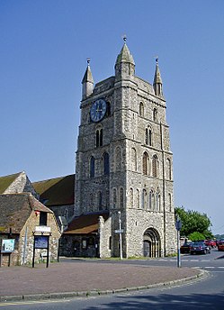
Like many towns on the marsh it has an impressive Norman church, the Church of St Nicholas, in the centre of town. This church originally stood at the harbourside, and its entrances are several feet below ground level. The church is also notable for the boat hooks still evident on the side walls.

New Romney's historic high street has several small and interesting shops. A few businesses closed after the opening of a branch of supermarket chain Sainsbury's, but the town retains much of its character. The former almshouses in West Street are noted historic buildings of Kent; they were founded in 1610 by John Southland, an important local magnate, and rebuilt in 1734. Adjacent to these is Plantagenet House and No 3 Old Stone Cottage, which originated as a single house constructed c. 13001350. [4] Researchers think it was originally the home of the Master of The Hospital of St John the Baptist, a large secular establishment. The hospital was operating by c. 1260 and flourished until the close of the fifteenth century. [5]

Three-quarters of a mile north of the town is the links golf course at Littlestone-on-Sea. The golf course was a favourite of Denis Thatcher, late husband of former British prime minister Margaret Thatcher, and has been used several times for the qualifying rounds of The Open Championship.

Transport

The Romney, Hythe and Dymchurch Railway has a station at the extreme east of New Romney, which as well as being a major tourist attraction was also used by students travelling to school until 2015. The station is about three-quarters of a mile east of the historic town centre.

New Romney was once serviced by the New Romney and Littlestone-On-Sea railway station which was part of the Lydd Line. The station was sited halfway between New Romney and Littlestone-on-Sea. As built the station had two platforms and a small goods yard with four sidings, a goods shed, cattle dock, coal wharves, end loading dock, water tower and other small buildings. The up platform was rarely used in latter years other than as a livestock loading dock. The station was originally called New Romney & Littlestone with on-Sea being added in October 1888. In 1927 a single line extension was built with an unprotected level crossing to an exchange siding with the adjacent Romney Hythe and Dymchurch Railway station on the opposite side of the Station Road; it was used to deliver coal to that railway. The signal box was taken out of use in the 1950s and goods service was withdrawn in 1964. The station was closed in 1967 and replaced with a bus service.

New Romney is easily accessible by road, sitting astride the A259 (which runs from Folkestone to Havant). Several bus services run to and through New Romney from Hastings, Folkestone and Ashford.

Media

New Romney has one dedicated weekly newspaper, the Kentish Express (published by the KM Group) is the only weekly newspaper for the Romney Marsh covering the town. There is also the Folkestone Herald (which incorporated the Romney Marsh Herald in 2014, published by Kent Regional News and Media). The local radio station for New Romney is KMFM Ashford which contains Marsh-based adverts amongst a county-wide station, and New Romney is also served by the county-wide stations Heart, Gold and BBC Radio Kent.

Cinque Ports Radio 100.2FM is the community radio station for Romney Marsh and has been broadcasting since 7th March 2022 replacing Shoreline FM which now broadcasts online to the same area as Shoreline Easy and previously broadcast on 100.2FM since January 2020 [6]

In 1951 the Richard Burton, Roger Livesey, and Honor Blackman film Green Grow the Rushes was made on location in and around New Romney and in nearby St Mary in the Marsh.

Namesakes

In 1762 Thomas Fairfax, 6th Lord Fairfax of Cameron named the town of Romney in present-day West Virginia in the United States after the town of New Romney.

Arms

Coat of arms of New Romney
Coat of arms of New Romney, England.svg
Notes
Recorded at the Visitation of 1619, for the Borough of New Romney. [7]
Escutcheon
Azure three Lions passant guardant in pale Or.

See also

Related Research Articles

<span class="mw-page-title-main">Folkestone</span> Town in Kent, England

Folkestone is a port town on the English Channel, in Kent, south-east England. The town lies on the southern edge of the North Downs at a valley between two cliffs. It was an important harbour, shipping port and fashionable coastal resort for most part of the 19th and mid 20th centuries.

<span class="mw-page-title-main">Romney, Hythe and Dymchurch Railway</span> Light railway in Kent, England

The Romney, Hythe and Dymchurch Railway (RH&DR) is a 15 in gauge light railway in Kent, England, operating steam and internal combustion locomotives. The 13+12-mile (21.7 km) line runs from the Cinque Port of Hythe via Dymchurch, St. Mary's Bay, New Romney and Romney Sands to Dungeness, close to the Dungeness nuclear power stations and Dungeness Lighthouse. The line is double track north of New Romney and single track south.

<span class="mw-page-title-main">Cinque Ports</span> Historic group of English coastal towns

The confederation of Cinque Ports is a historic group of coastal towns in south-east England – predominantly in Kent and Sussex, with one outlier (Brightlingsea) in Essex. The name is Old French, meaning "five harbours", and alludes to the original five members. At its peak in the Late Middle Ages, the confederation included over 40 members. There are now a total of 14 members: five "head ports", two "ancient towns" and seven "limbs".

<span class="mw-page-title-main">Romney Marsh</span> Wetland in south-east England

Romney Marsh is a sparsely populated wetland area in the counties of Kent and East Sussex in the south-east of England. It covers about 100 square miles (260 km2). The Marsh has been in use for centuries, though its inhabitants commonly suffered from malaria until the 18th century. Due to its location, geography and isolation, it was a smuggler's paradise between the 1600s and 1800s. The area has long been used for sheep pasture: Romney Marsh sheep are considered one of the most successful and important sheep breeds. Criss-crossed with numerous waterways, and with some areas lying below sea level, the Marsh has over time sustained a gradual level of reclamation, both through natural causes and by human intervention.

<span class="mw-page-title-main">Hythe, Kent</span> Town in Kent, England

Hythe is a market town and civil parish on the edge of Romney Marsh, in the district of Folkestone and Hythe in Kent, England. The word Hythe or Hithe is an Old English word meaning haven or landing place.

<span class="mw-page-title-main">Rye, East Sussex</span> Town in East Sussex, England

Rye is a town and civil parish in the Rother district of East Sussex, England, two miles from the sea at the confluence of three rivers: the Rother, the Tillingham and the Brede. An important member of the mediaeval Cinque Ports confederation, it was at the head of an embayment of the English Channel, and almost entirely surrounded by the sea.

<span class="mw-page-title-main">Lydd</span> Human settlement in England

Lydd is a town and electoral ward in Kent, England, lying on Romney Marsh. It is one of the larger settlements on the marsh, and the most southerly town in Kent. Lydd reached the height of its prosperity during the 13th century, when it was a corporate member of the Cinque Ports, a "limb" of Romney. Actually located on Denge Marsh, Lydd was one of the first sandy islands to form as the bay evolved into what is now called Romney Marsh.

<span class="mw-page-title-main">Folkestone and Hythe District</span> Non-metropolitan district in England

Folkestone and Hythe is a local government district in Kent, England, in the south-east of the county. Its council is based in the town of Folkestone. The authority was renamed from Shepway in April 2018, and therefore has the same name as the Folkestone and Hythe parliamentary constituency, although a somewhat narrower area is covered by the district.

<span class="mw-page-title-main">Dymchurch</span> Human settlement in England

Dymchurch is a village and civil parish in the Folkestone and Hythe district of Kent, England. The village is located on the coast five miles (8 km) south-west of Hythe, and on the Romney Marsh.

<span class="mw-page-title-main">Royal Military Canal</span> Defensive canal in southern England

The Royal Military Canal is a canal running for 28 miles (45 km) between Seabrook near Folkestone and Cliff End near Hastings, following the old cliff line bordering Romney Marsh, which was constructed as a defence against the possible invasion of England during the Napoleonic Wars.

<span class="mw-page-title-main">Hythe railway station (Romney, Hythe and Dymchurch Railway)</span> Railway station in Kent, England

Hythe station is the northern terminus of the Romney, Hythe and Dymchurch Railway. The station has curved platforms with an overall roof, loco release road, former engine shed, signalbox with 16 lever frame, and a turntable. In terms of passenger bookings Hythe is the busiest station on the railway.

<span class="mw-page-title-main">West Hythe</span> Human settlement in England

West Hythe is a hamlet and former civil parish, now in the parish of Hythe, in the Folkestone and Hythe district, in Kent, England, near Palmarsh and a few miles west of the cinque port town of Hythe. In 2020 it had an estimated population of 566.

<span class="mw-page-title-main">Greatstone-on-Sea</span> Human settlement in England

Greatstone is a village on the coast of Romney Marsh in Kent, England. It is east of the town of New Romney and split between the civil parishes of New Romney and Lydd.

<span class="mw-page-title-main">Old Romney</span> Human settlement in England

Old Romney is a village and civil parish in the Folkestone and Hythe district of Kent, England.

<span class="mw-page-title-main">Burmarsh</span> Human settlement in England

Burmarsh is a village and civil parish in the Folkestone and Hythe District of Kent, England. The village is located three miles (4.8 km) west of Hythe on the Romney Marsh. The Burmarsh Road connects the village to the once fully operating Burmarsh Road train station. The closest major settlement is Folkestone which is a minimum of 9.5 mile car journey.

<span class="mw-page-title-main">Small Hythe</span> Human settlement in England

Small Hythe is a hamlet near Tenterden in Kent, England. The population is included in Tenterden.

<span class="mw-page-title-main">Greatstone-on-Sea Halt railway station</span> Former railway station in England

Greatstone-on-Sea Halt was a railway station which served the modern village of Greatstone-on-Sea in Kent, England. The station opened in 1937 and closed in 1967.

<span class="mw-page-title-main">New Romney and Littlestone-on-Sea railway station</span> Former railway station in England

New Romney and Littlestone-on-Sea was a railway station which lay in between the villages of New Romney and Littlestone-on-Sea in Kent, England. The station opened in 1884 and closed in 1967.

<span class="mw-page-title-main">South England flood of February 1287</span> Storm surge on southern coast of England

In February 1287 a storm hit the southern coast of England with such ferocity that whole areas of coastline were redrawn. Silting up and cliff collapses led to towns that had stood by the sea finding themselves landlocked, while others that had been inland found themselves with access to the sea.

Palmarsh is a community in Folkestone and Hythe district, in the County of Kent, England. In origin it was a hamlet on the edge of the Romney Marsh, but modern development to the west of Hythe in a corridor along the A259 coastal road, has led to the joining together of the ancient town and cinque port of Hythe and the rural hamlet of Palmarsh in a single conurbation.

References

  1. "Town population 2011". Archived from the original on 4 March 2016. Retrieved 5 October 2015.
  2. Canterbury Archaeological Trust, New Romney Unearthed (web page) Archived 9 May 2008 at the Wayback Machine .
    "Kent Sites" [ permanent dead link ]
    , and "Post Excavation and Research" [ permanent dead link ], both in Canterbury's Archaeology, vol. 29 (2004–05).
    Draper, Gillian, Frank Meddens, et al., The Sea and the Marsh: The Medieval Cinque Port of New Romney Revealed through Archaeological Excavations and Historical Research. PCA Monograph 10. Pre-Construct Archaeology Ltd (2009). ISBN   978-0954293895. Archived 1 August 2013 at the Wayback Machine
  3. Historic England. "Town Hall (1068989)". National Heritage List for England . Retrieved 19 November 2021.
  4. Archaeology South East, UCL, report by David Martin, 2004
  5. Victoria History and a report by Dr Gillian Draper in the possession of the writer
  6. static.ofcom.org.uk/static/radiolicensing/html/radio-stations/community/cr103150ba1shorelinefm.htm
  7. "Civic Heraldry of England". Robert Young. Archived from the original on 22 January 2021. Retrieved 12 March 2019.

Commons-logo.svg Media related to New Romney at Wikimedia Commons