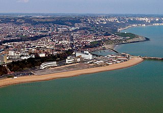
Folkestone is a coastal town on the English Channel, in Kent, south-east England. The town lies on the southern edge of the North Downs at a valley between two cliffs. It was an important harbour, shipping port, and fashionable coastal resort for most of the 19th and mid-20th centuries.
Folkestone and Hythe is a local government district in Kent, England. It lies in the south-east of the county, on the coast of the English Channel. The district was formed in 1974 and was originally named Shepway after one of the ancient lathes of Kent, which had covered a similar area. The district was renamed in 2018. The council is based in Folkestone, the district's largest town. The district also includes the towns of Hawkinge, Hythe, Lydd and New Romney, along with numerous villages and surrounding rural areas.

Sandgate is a village in the Folkestone and Hythe Urban Area in the Folkestone and Hythe district of Kent, England. It had a population of 4,225 at the 2001 census. It is the site of Sandgate Castle, a Device Fort. H. G. Wells lived at Spade House, and it is also the birthplace of comedian Hattie Jacques. Sandgate is the location of the Shorncliffe Redoubt, a Napoleonic-era earthwork fort associated with Sir John Moore and the 95th Regiment of Foot, known as the 95th Rifles. St Paul's Church lies next to the Saga building, which is built on the site of Embrook House.

Folkestone and Hythe is a constituency in Kent represented in the House of Commons of the UK Parliament since 2024 by Tony Vaughan, a Labour MP.
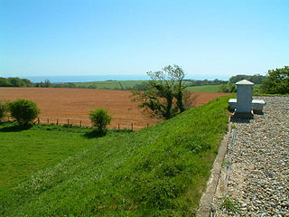
Cheriton Hill is a hill overlooking the English Channel near Folkestone in the south-east corner of Kent, England. The relatively low-lying hill is covered with farmland, villages, narrow lanes, and footpaths. The highest point is on a covered reservoir next to the trig point; the highest natural point is nearby, probably close to the road to the village of Paddlesworth, near a transmitter mast, but the relatively flat summit gives no real impression of being on top of a hill.

Hawkinge is a town and civil parish in the Folkestone and Hythe district of Kent, England. The original village of Hawkinge is actually just less than a mile due east of the present village centre; the village of Hawkinge was formed by the merging of Hawkinge and Uphill.

Folkestone West railway station is on the South Eastern Main Line in England, serving the western area of Folkestone, Kent. It is 69 miles 22 chains (111.5 km) down the line from London Charing Cross. All trains that call are operated by Southeastern.

Etchinghill is a village in Kent, England, about 5 km north of Hythe, and 1 km north of the Channel Tunnel terminal at Cheriton, near Folkestone. It is in the civil parish of Lyminge.

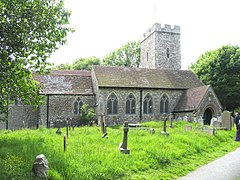
Lyminge is a village and civil parish in southeast Kent, England. It lies about five miles (8 km) from Folkestone and the Channel Tunnel, on the road passing through the Elham Valley. At the 2011 Census the population of Etchinghill was included. The Nailbourne stream begins in the village and flows north through the Valley, to become one of the tributary streams of the Great Stour. The hamlet of Ottinge lies to the NE on the road to Elham. Lyminge is home to the Grade II* listed Sibton Park, now owned by the Holiday Property Bond but previously a school.

Newington is a village and civil parish in the English county of Kent located 1 mile (1.6 km) north-west of Folkestone. It gives its name to Newington Parish Council, which has five councillors, and includes the hamlets of Arpinge and Beachborough. The village lies to the north of the M20 motorway and the A20 road; the Channel Tunnel complex is nearby.

Sellindge is a civil parish and village on the A20 road between Ashford and Folkestone in Kent, South East England. Sellindge is part of North Downs West Ward of Folkestone and Hythe District Council but part of the Elham ward of Kent County Council.
The area known as St Martin's Plain is located to the west of Cheriton, part of Folkestone, Kent, England. It is used by the British Army from Shorncliffe Army Camp for training; during wartime, and especially during World War I and World War II temporary camps were built here. It is also used by the Army Cadets on training weekends or camps.
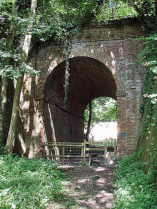
The Elham Valley Railway was a line connecting Folkestone and Canterbury in Kent, England. It opened between 1887 and 1889 and closed in 1947.
The Sandgate branch was a three mile long railway branch line that ran from Sandling railway station in Kent on the South Eastern Main Line to Hythe and Sandgate railway stations. It opened in 1874 and closed completely in 1951.

Cheriton Road is a complex of sports grounds at Folkestone in the English county of Kent. The complex includes football pitches, a cricket ground, hockey pitches, netball courts and an indoor sports facility. It includes the home ground of Folkestone Invicta F.C., known as The Alcaline Stadium for sponsorship reasons, and the Three Hills Sports Park which includes the home grounds of Folkestone Cricket Club and Folkestone Optimist Hockey Club. The cricket ground, which was previously called the Cheriton Road Sports Ground, was used by Kent County Cricket Club for top level cricket matches.

Shorncliffe Army Camp is a British Army installation near Cheriton in Kent, established in 1794. The camp, described as "the birthplace of the modern British Army", previously consisted of Ross Barracks, Burgoyne Barracks, Somerset Barracks, Napier Barracks, Risborough Barracks and Sir John Moore Barracks, however, due to closures, the latter is all that remains in military use.
Sandgate Plain was a cricket ground in Folkestone in Kent. The ground was situated on the Folkestone Leas, an area along the coast to the west of the town centre close to the village of Sandgate. The ground was one of two located either side of the Upper Folkestone Road, now the A259 Sandgate Road, which were established by 1859. The ground was used by Folkestone Cricket Club between 1859 and 1901.
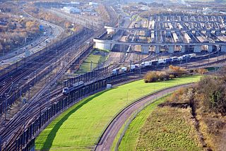
The Eurotunnel Folkestone Terminal is a railway terminal built for the transport of road-going vehicles on specially constructed trains through the Channel Tunnel. The station is located in Cheriton, a northern suburb of the town of Folkestone in the county of Kent. It is the terminal for the United Kingdom. On the French side is the Eurotunnel Calais Terminal located at Coquelles, near Calais. The passenger service building at the Eurotunnel Folkestone Terminal is called the Victor Hugo Terminal, named for the French author Victor Hugo.

The Eurotunnel Calais Terminal is a railway terminal built for the transport of road-going vehicles on specially constructed trains through the Channel Tunnel. The station is located in the commune of Coquelles in the Pas-de-Calais department near the city of Calais. It is the terminal for the France and by extension the rest of Continental Europe. On the British side is the Eurotunnel Folkestone Terminal located at Cheriton, near Folkestone. The passenger service building at the Eurotunnel Calais Terminal is called the Charles Dickens Terminal, named for the British author Charles Dickens.
The White Cliffs Countryside Partnership was established in 1989, to help landowners care for the special coast and countryside of Dover and Folkestone and Hythe districts. This includes the only two stretches of Heritage Coast in Kent; the Dover-Folkestone Heritage Coast and the South Foreland Heritage Coast between Dover and Kingsdown near Deal.