Coventina was a Romano-British goddess of wells and springs. She is known from multiple inscriptions at one site in Northumberland, England, an area surrounding a wellspring near Carrawburgh on Hadrian's Wall. It is possible that other inscriptions, two from Hispania and one from Narbonensis, refer to Coventina, but this is disputed.

Lympne, formerly also Lymne, is a village on the former shallow-gradient sea cliffs above the expansive agricultural plain of Romney Marsh in Kent. The settlement forms an L shape stretching from Port Lympne Zoo via Lympne Castle facing Lympne Industrial Park then via the main settlement to Newingreen in the north, centred 11 km (7 mi) west of Folkestone, 2.3 mi (3.7 km) west of Hythe and 13 km (8.1 mi) ESE of Ashford.
The naval forces of the ancient Roman state were instrumental in the Roman conquest of the Mediterranean Basin, but it never enjoyed the prestige of the Roman legions. Throughout their history, the Romans remained a primarily land-based people and relied partially on their more nautically inclined subjects, such as the Greeks and the Egyptians, to build their ships. Because of that, the navy was never completely embraced by the Roman state, and deemed somewhat "un-Roman".

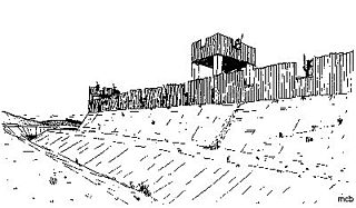
Pevensey Castle is a medieval castle and former Roman Saxon Shore fort at Pevensey in the English county of East Sussex. The site is a scheduled monument in the care of English Heritage and is open to visitors. Built around 290 AD and known to the Romans as Anderitum, the fort appears to have been the base for a fleet called the Classis Anderidaensis. The reasons for its construction are unclear; long thought to have been part of a Roman defensive system to guard the British and Gallic coasts against Saxon pirates, it has more recently been suggested that Anderitum and the other Saxon Shore forts were built by a usurper in an ultimately unsuccessful attempt to prevent Rome from reimposing its control over Britain.

Dubris, also known as Portus Dubris and Dubrae, was a port in Roman Britain on the site of present-day Dover, Kent, England.
The Classis Britannica was a provincial naval fleet of the navy of ancient Rome. Its purpose was to control the English Channel and the waters around the Roman province of Britannia. Unlike modern "fighting navies", its job was largely the logistical movement of personnel and support, and keeping open communication routes across the Channel.

Gariannonum, or Gariannum, was a Roman Saxon Shore fort in Norfolk, England. The Notitia Dignitatum, a Roman Army "order of battle" from about AD 400, lists nine forts of the Saxon Shore in south and east England, among which one was called Gariannonor. It has been much discussed over the years in terms of spelling, purpose, and location. The fort is listed as being commanded by the Praepositus equitum stablesianorum, implying its garrison was a cavalry of a form originated in the late 3rd century, the Equites Stablesiani. Both proposed sites show archaeological evidence for military occupation beginning at around the time this type of unit began use.

Durovernum Cantiacorum was a town and hillfort in Roman Britain at the site of present-day Canterbury in Kent. It occupied a strategic location on Watling Street at the best local crossing of the Stour, which prompted a convergence of roads connected to the ports of Dubris (Dover), Rutupiae (Richborough), Regulbium (Reculver) and Portus Lemanis (Lympne). Considerable archaeological evidence of Roman activity has been found in Canterbury, much of which can now be found in the Roman Museum built on the remains of a Roman townhouse.

Portus Adurni was a Roman fort in the Roman province of Britannia situated at the north end of Portsmouth Harbour. It was part of the Saxon Shore, and is the best-preserved Roman fort north of the Alps. Around an eighth of the fort has been excavated.

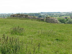
Anderitum was a Saxon Shore fort in the Roman province of Britannia. The ruins adjoin the west end of the village of Pevensey in East Sussex, England. The fort was built in the 290s and was abandoned after it was sacked in 471. It was re-inhabited by Saxons and in the 11th century the Normans built a castle within the east end of the fort.

Glannoventa is a Roman fort associated with the Roman naval base at Ravenglass in Cumbria, England. Its name is derived from the Latin place-name Clanoventa as recorded in the 2nd-century Antonine Itinerary, Glannibanta in the 4th-century Notitia Dignitatum, and Cantiventi in the 6th-century Ravenna Cosmography.
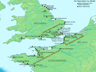
The Saxon Shore was a military command of the Late Roman Empire, consisting of a series of fortifications on both sides of the Channel. It was established in the late 3rd century and was led by the "Count of the Saxon Shore". In the late 4th century, his functions were limited to Britain, while the fortifications in Gaul were established as separate commands. Several well-preserved Saxon Shore forts survive in east and south-east England.
Concangis was an auxiliary castra in the Roman province of Lower Britain. Its ruins are located in Chester-le-Street, Durham, in England, and are now known as Chester-le-Street Roman Fort. It is situated 6 miles (10 km) north of Durham and 8 miles (13 km) south of Newcastle upon Tyne.
Maia, or Mais, in Cumbria, England was a Roman fort on Hadrian's Wall, and was the last fort at the western end of the Wall, overlooking the Solway Firth.

Branodunum was an ancient Roman fort to the east of the modern English village of Brancaster in Norfolk. Its Roman name derives from the local Celtic language, and may mean "fort of the raven".

Regulbium was the name of an ancient Roman fort of the Saxon Shore in the vicinity of the modern English resort of Reculver in Kent. Its name derives from the local Brythonic language, meaning "great headland" (*Rogulbion).

Othona or Othonae was the name of an ancient Roman fort of the Saxon Shore at the sea's edge near the modern village of Bradwell-on-Sea in Essex, England. The Old English name Ythanceaster for the locality derives from the Roman name.

The Roman Fort of Carpow was situated at the confluence of the rivers Tay and Earn in what is now Scotland.
The Limenwara or Limenware were a people of Anglo-Saxon England whose territory formed a regio or early administrative subdivision of the Kingdom of Kent. The name means "Limen-dwellers", with "Limen" being the name of the former eastern arm of the River Rother, which at that time entered the sea at Lympne.

Walton Castle was a Saxon Shore Fort in the Roman province of Britannia. The fort was reused by the Normans who used it as the bailey for a castle. It stood 30 metres above sea level but was destroyed by coastal erosion in the 18th century. It was located in the village of Walton, Suffolk, now part of Felixstowe.