
Anglo-Saxon architecture was a period in the history of architecture in England from the mid-5th century until the Norman Conquest of 1066. Anglo-Saxon secular buildings in Britain were generally simple, constructed mainly using timber with thatch for roofing. No universally accepted example survives above ground. Generally preferring not to settle within the old Roman cities, the Anglo-Saxons built small towns near their centres of agriculture, at fords in rivers or sited to serve as ports. In each town, a main hall was in the centre, provided with a central hearth.
Maldon District is a local government district in Essex, England. The district is managed by Maldon District Council, which is based in Maldon, the largest town in the district. The district also includes the town of Burnham-on-Crouch and numerous villages, including Heybridge, Wickham Bishops, Southminster, Tolleshunt D'Arcy and Tollesbury. The district covers the Dengie peninsula to the south of Maldon and the Thurstable Hundred area to the north of the Blackwater Estuary, a total area of 358.78 km2.

The Chapel of St Peter-on-the-Wall, Bradwell-on-Sea, is a Christian church dating from the years 660–662 and among the oldest largely intact churches in England. It is in regular use by the nearby Othona Community, in addition to Church of England services. It is a Grade I listed building.

In the Iron Age, Essex was home to the Trinovantes. In AD 43 the Roman conquest of Britain saw Roman control established over Essex, with the centre of Roman power in Britain being, for a time, Colchester. The Boudiccan revolt saw Colchester razed, but it was rebuilt.
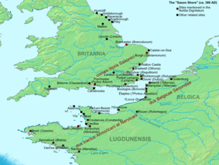
The Count of the Saxon Shore for Britain was the head of the Saxon Shore military command of the later Roman Empire.

Tillingham is a small village and civil parish with 1,015 inhabitants in 2001, increasing to 1,058 at the 2011 Census. Located 8 miles (13 km) from Burnham-on-Crouch and 3 miles (4.8 km) from Bradwell-on-Sea, on the Dengie Peninsula which is a Maldon District part of the ceremonial county of Essex in England. It is one of the villages that make up the ancient Dengie Hundred, which is bounded by the North Sea, River Blackwater and River Crouch.

Pevensey Castle is a medieval castle and former Roman Saxon Shore fort at Pevensey in the English county of East Sussex. The site is a scheduled monument in the care of English Heritage and is open to visitors. Built around 290 AD and known to the Romans as Anderitum, the fort appears to have been the base for a fleet called the Classis Anderidaensis. The reasons for its construction are unclear; long thought to have been part of a Roman defensive system to guard the British and Gallic coasts against Saxon pirates, it has more recently been suggested that Anderitum and the other Saxon Shore forts were built by a usurper in an ultimately unsuccessful attempt to prevent Rome from reimposing its control over Britain.

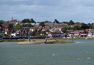
Bradwell-on-Sea is a village and civil parish in Essex, England; it is on the Dengie peninsula. It is located 5.6 mi (9.0 km) north-north-east of Southminster and is 19 mi (31 km) east of the county town of Chelmsford. The village is in the District of Maldon and in the parliamentary constituency of Maldon, whose boundaries were last varied at the 2010 general election. In 2011, it had a population of 863, a decline from 877 in the previous census. In 2021 the population was 892.

Southminster is a town and civil parish on the Dengie Peninsula in the Maldon district of Essex in the East of England. It lies about 3 miles (4.8 km) north of Burnham-on-Crouch and 10 miles (16 km) south-east of Maldon; it is approximately 52 miles (84 km) east-north-east of London. To the north is the River Blackwater, which is tidal, and, since Roman times, has been the gateway to trading in the area.

Gariannonum, or Gariannum, was a Roman Saxon Shore fort in Norfolk, England. The Notitia Dignitatum, a Roman Army "order of battle" from about AD 400, lists nine forts of the Saxon Shore in south and east England, among which one was called Gariannonor. It has been much discussed over the years in terms of spelling, purpose, and location. The fort is listed as being commanded by the Praepositus equitum stablesianorum, implying its garrison was a cavalry of a form originated in the late 3rd century, the Equites Stablesiani. Both proposed sites show archaeological evidence for military occupation beginning at around the time this type of unit began use.

Dommoc, a place not certainly identified but probably within the modern county of Suffolk, was the original seat of the Anglo-Saxon bishops of the Kingdom of East Anglia. It was established by Sigeberht of East Anglia for Saint Felix in c. 629–631. It remained the bishopric of all East Anglia until c. 673, when Theodore of Tarsus, Archbishop of Canterbury, divided the see and created a second bishopric, the See of Elmham associated with both North Elmham, Norfolk and South Elmham, Suffolk. The see of Dommoc continued to exist until the time of the Viking Wars of the 860s, after which it lapsed.

Anderitum was a Saxon Shore fort in the Roman province of Britannia. The ruins adjoin the west end of the village of Pevensey in East Sussex, England. The fort was built in the 290s and was abandoned after it was sacked in 471. It was re-inhabited by Saxons and in the 11th century the Normans built a castle within the east end of the fort.

The Saxon Shore was a military command of the Late Roman Empire, consisting of a series of fortifications on both sides of the Channel. It was established in the late 3rd century and was led by the "Count of the Saxon Shore". In the late 4th century, his functions were limited to Britain, while the fortifications in Gaul were established as separate commands. Several well-preserved Saxon Shore forts survive in east and south-east England.

Branodunum was an ancient Roman fort to the east of the modern English village of Brancaster in Norfolk.

Regulbium was the name of an ancient Roman fort of the Saxon Shore in the vicinity of the modern English resort of Reculver in Kent. Its name derives from the local Brythonic language, meaning "great headland" (*Rogulbion).

Portus Lemanis, also known as Lemanae, was the Latin name of a Roman Saxon Shore fort, settlement and port in southern Kent. The modern village of Lympne derives its name from the ancient port. The site, known locally as Stutfall Castle, is on private land which is accessible by public footpath.

Burgh Castle is the site of one of nine Roman Saxon Shore forts constructed in England around the 3rd century AD, to hold troops as a defence against Saxon raids up the rivers of the east and south coasts of southern Britain. It is located on the summit of ground sloping steeply towards the estuary of the River Waveney, in the civil parish of Burgh Castle, in the county of Norfolk.
The Abulci were a Roman auxiliary company (numerus) mentioned in the Notitia Dignitatum as composing part of the garrison of the Saxon Shore Fort of Anderida – the title of one position is listed as "Praepositus numeri Abulcorum, Anderidos". The unit may have been recruited from the territory of Abula in Hispania Tarraconensis, although a Gaulish origin has also been suggested.

Walton Castle was a Saxon Shore Fort in the Roman province of Britannia. The fort was reused by the Normans who used it as the bailey for a castle. It stood 30 metres above sea level but was destroyed by coastal erosion in the 18th century. It was located in the village of Walton, Suffolk, now part of Felixstowe.

St Peter's Way is a long-distance footpath in Essex, England. The 41-mile (66 km) path leads from Chipping Ongar to the 7th-century Chapel of St Peter-on-the-Wall at Bradwell-on-Sea. It is waymarked, and shown on Ordnance Survey mapping.

