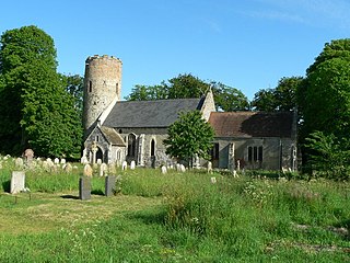
Caister Roman Site

Last updated

Caister Roman Site
Norfolk, England
CaisterRomanSite.jpg
Caister Roman Site
Norfolk UK location map.svg
Red pog.svg
Caister Roman Site
Coordinates 52°39′00″N1°43′09″E / 52.6500°N 1.7193°E / 52.6500; 1.7193 Coordinates: 52°39′00″N1°43′09″E / 52.6500°N 1.7193°E / 52.6500; 1.7193
Grid reference grid reference TG517122
TypeRoman Shore Fort
Site information
Owner EH icon.svg English Heritage
Open to
the public
Yes
Conditionpartially excavated remains
Site history
MaterialsFlint and some brick/tile

Caister Roman Site is a Roman Saxon Shore fort, located in Caister-on-Sea, Norfolk, England. It was constructed around AD 200 for a unit of the Roman army and navy and occupied until around 370-390 AD. [1] This fort was possibly known as Gariannonum, although the single record that describes it as such may also mean the Roman site at Burgh Castle.

Contents

Description

The fort was originally 3.5 ha (8.6 acres) in size and roughly square in shape, with large stone perimeter walls 4 to 5 m (13 to 16 ft) high, earth ramparts and ditches of 175 m (574 ft) in length on all four sides. There were defensive towers at the corners and fortified gate houses in the middle of each side [1] [2]

At the time of its construction, the site of the fort would have been on the north side of an estuary, with a pebbled street from the fort's south gate leading a short distance to a harbour or docks. [3] In around AD 260 a fort at Burgh Castle was constructed on the opposite side of the estuary, with both forts probably serving to protect Roman shipping in the estuary. [2]

Between 1951 and 1955, a section of the fort was excavated with the main structures left exposed, including part of the south gate, the western section of the south wall perimeter defences, building foundations, and main road. The remainder of the site, approximately 3.15 ha (7.8 acres) now lies under modern housing. [3]

Detail of the hypocaust at the site. Caister Roman Site Hypocaust detail.jpg
Detail of the hypocaust at the site.
A detail of part of the remaining building structure at Caister Caister Roman Site building detail 2.jpg
A detail of part of the remaining building structure at Caister

Inside the current visitor entrance is a large defensive ditch, the innermost of a series of ditches around the fort, part of the south gate, and to the left of the gate the remains of a small rectangular guard chamber. [3]

Just to the north of the south wall, and on a roughly east–west alignment are the remains of a building of approximately 45 m (148 ft) in length with at least six rooms of unequal size, and a further wing of the building extends northwards at the western end. On the southern side is a parallel wall which could be part of a portico, and perhaps would have served also to retain the inner face of the earthen bank behind the south wall of the fort. [3] The second room from the west contains an example of a hypocaust heated floor. On the north side of the building is a corridor running along the southern and south eastern sides of a rectangular courtyard beyond. It is likely that the building was in use during the later third and fourth centuries AD and likely to have served various domestic and industrial functions at different times. There is evidence that the building was severely damaged by fire in the later fourth century. Within the courtyard area are parts of other possibly earlier buildings, which include for various structures and the remains of a corn-drying kiln and a water tank. [3]

During the original archaeological digs, this building had been incorrectly interpreted as either a hotel or seamen's hostel, and it was also assumed that the building north of here was a brothel, however since then both buildings have been reinterpreted as forming part of the original fort. [3]

Following the Roman occupation, the site remained unoccupied until the Middle and Late Saxon periods (between 650-850 and 850-1066 AD), until a settlement was established near the centre of the fort. To the south of the fort a large Saxon cemetery has been excavated. [3]

Today (2012) the remains of the fort are open free of charge to the public by English Heritage.

Finds

Finds during the archaeological excavation include four Roman coins of the mid 4th century, as well as seven small hoards, the remains of wattle and daub walling, pottery, glass, part of a pewter plate, and grain.

Location

The site is located on the western edge of the town of Caister-on-Sea, in the county of Norfolk. At the time of its construction, the site of the fort would have been on the north side of an estuary, at the mouths of the Rivers Ant, Bure, Yare, and Waveney. Today however, the northward extension of the Yarmouth sandbank has meant that this shore fort now lies some distance inland. [3] The Roman Saxon Shore fort of Burgh Castle lies a few miles to the southwest; its ruins are much more extensive than those at Caister.

A view of the site, from the south west corner of the outer ditch, and looking northeast Roman Fort, Caister on Sea - geograph.org.uk - 771327.jpg
A view of the site, from the south west corner of the outer ditch, and looking northeast

See also

Related Research Articles

Caister-on-Sea, also known colloquially as Caister, is a large village and seaside resort in Norfolk, England. It is close to the large town of Great Yarmouth. At the 2001 census it had a population of 8,756 and 3,970 households, the population increasing to 8,901 at the 2011 Census.

<i>Limes</i> (Roman Empire) Frontier and border defences of the Roman Empire

Līmes is a modern term used primarily for the Germanic border defence or delimiting system of Ancient Rome marking the borders of the Roman Empire, but it was not used by the Romans for that purpose. The term has been extended to refer to the frontier defences in other parts of the empire, such as in the east and in Africa.

<span class="mw-page-title-main">London Wall</span> Defensive wall built around London

The London Wall was a defensive wall first built by the Romans around the strategically important port town of Londinium in c. AD 200, and is now the name of a modern street in the City of London.

<span class="mw-page-title-main">Wansdyke</span> Early medieval defensive linear earthworks in the West Country of England

Wansdyke is a series of early medieval defensive linear earthworks in the West Country of England, consisting of a ditch and a running embankment from the ditch spoil, with the ditching facing north.

<span class="mw-page-title-main">Chanctonbury Ring</span>

Chanctonbury Ring is a prehistoric hill fort atop Chanctonbury Hill on the South Downs, on the border of the civil parishes of Washington and Wiston in the English county of West Sussex. A ridgeway, now part of the South Downs Way, runs along the hill. It forms part of an ensemble of associated historical features created over a span of more than 2,000 years, including round barrows dating from the Bronze Age to the Saxon periods and dykes dating from the Iron Age and Roman periods.

<span class="mw-page-title-main">Richborough Castle</span> Ancient fort in Kent, England

Richborough Castle is a Roman Saxon Shore fort better known as Richborough Roman Fort. It is situated in Richborough near Sandwich, Kent. Substantial remains of the massive fort walls still stand to a height of several metres.

<span class="mw-page-title-main">Pevensey Castle</span> Castle in East Sussex, England

Pevensey Castle is a medieval castle and former Roman Saxon Shore fort at Pevensey in the English county of East Sussex. The site is a scheduled monument in the care of English Heritage and is open to visitors. Built around 290 AD and known to the Romans as Anderitum, the fort appears to have been the base for a fleet called the Classis Anderidaensis. The reasons for its construction are unclear; long thought to have been part of a Roman defensive system to guard the British and Gallic coasts against Saxon pirates, it has more recently been suggested that Anderitum and the other Saxon Shore forts were built by a usurper in an ultimately unsuccessful attempt to prevent Rome from reimposing its control over Britain.

<span class="mw-page-title-main">Ambleside Roman Fort</span> Roman fort in Cumbria, United Kingdom

Ambleside Roman Fort is the modern name given to the remains of a fort of the Roman province of Britannia. The ruins have been tentatively identified as Galava, mentioned in the Antonine Itinerary. Dating to the 1st or 2nd century AD, its ruins are located on the northern shore of Windermere at Waterhead, near Ambleside, in the English county of Cumbria, within the boundaries of the Lake District National Park.

<span class="mw-page-title-main">Gariannonum</span> Roman fort in Norfolk, England

Gariannonum, or Gariannum, was a Roman Saxon Shore fort in Norfolk, England. The Notitia Dignitatum, a Roman Army "order of battle" from about AD 400, lists nine forts of the Saxon Shore in south and east England, among which one was called Gariannonor. It has been much discussed over the years in terms of spelling, purpose, and location. The fort is listed as being commanded by the Praepositus equitum stablesianorum, implying its garrison was a cavalry of a form originated in the late 3rd century, the Equites Stablesiani. Both proposed sites show archaeological evidence for military occupation beginning at around the time this type of unit began use.

<span class="mw-page-title-main">Portus Adurni</span> Roman fort

Portus Adurni was a Roman fort in the Roman province of Britannia situated at the north end of Portsmouth Harbour. It was part of the Saxon Shore, and is the best-preserved Roman fort north of the Alps. Around an eighth of the fort has been excavated.

<span class="mw-page-title-main">Chester city walls</span> Fortification in Chester, England

Chester city walls consist of a defensive structure built to protect the city of Chester in Cheshire, England. Their construction was started by the Romans when they established the fortress of Deva Victrix between 70 and 80 [CE]. It originated with a rampart of earth and turf surmounted by a wooden palisade. From about 100 CE they were reconstructed using sandstone, but were not completed until over 100 years later. Following the Roman occupation nothing is known about the condition of the walls until Æthelflæd refounded Chester as a burgh in 907. The defences were improved, although the precise nature of the improvement is not known. After the Norman conquest, the walls were extended to the west and the south to form a complete circuit of the medieval city. The circuit was probably complete by the middle of the 12th century.

<span class="mw-page-title-main">Saxon Shore</span> Military command during the Late Roman Empire

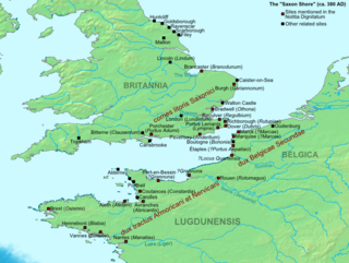
The Saxon Shore was a military command of the late Roman Empire, consisting of a series of fortifications on both sides of the Channel. It was established in the late 3rd century and was led by the "Count of the Saxon Shore". In the late 4th century, his functions were limited to Britain, while the fortifications in Gaul were established as separate commands. Several Saxon Shore forts survive in east and south-east England.

<span class="mw-page-title-main">Condercum</span> Roman fort in England

Condercum was a Roman fort on the site of the modern-day Condercum Estate in Benwell, a suburb of Newcastle upon Tyne, England. It was the third fort on Hadrian's Wall, after Segedunum (Wallsend) and Pons Aelius (Newcastle), and was situated on a hilltop 2 miles (3 km) to the west of the city.

<span class="mw-page-title-main">Regulbium</span> Roman fort in Kent, England

Regulbium was the name of an ancient Roman fort of the Saxon Shore in the vicinity of the modern English resort of Reculver in Kent. Its name derives from the local Brythonic language, meaning "great headland" (*Rogulbion).

<span class="mw-page-title-main">Othona</span> Roman fort

Othona or Othonae was the name of an ancient Roman fort of the Saxon Shore at the sea's edge near the modern village of Bradwell-on-Sea in Essex, England. The Old English name Ythanceaster for the locality derives from the Roman name.

<span class="mw-page-title-main">Eddisbury hill fort</span> Iron Age hillfort in Cheshire, England

Eddisbury hill fort, also known as Castle Ditch, is an Iron Age hill fort near Delamere, Cheshire, in northern England. Hill forts are fortified hill-top settlements constructed across Britain during the Iron Age. Eddisbury is the largest and most complex of the seven hill forts in the county of Cheshire. It was constructed before 200–100 BC and expanded in 1–50 AD. In the 1st century AD, the Romans slighted the site. It was reoccupied in the 6th–8th centuries AD, and an Anglo-Saxon burh was probably established at Eddisbury in 914. In the medieval and post-medieval periods quarrying and farming have damaged the site. Ownership is currently split between the Forestry Commission and a local farm. Eddisbury is protected as a Scheduled Ancient Monument.

<span class="mw-page-title-main">Blewburton Hill</span> Hillfort in Oxfordshire, England

Blewburton Hill is the site of an Iron Age hillfort located in Oxfordshire, in the southeast of England. It was a univallate hillfort. The area is mostly farmland with some small areas of wooded copse to the south and the northeast. The hill fort may have been occupied from the 4th century BC to the 1st century BC, and replaced a small settlement surrounded by a stockade, which is estimated to have been built in the 5th or 6th century BC.

<span class="mw-page-title-main">Burgh Castle (Roman fortification)</span>

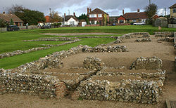
Burgh Castle is the site of one of nine Roman Saxon Shore forts constructed in England around the 3rd century AD, to hold troops as a defence against Saxon raids up the rivers of the east and south coasts of southern Britain. It is located on the summit of ground sloping steeply towards the estuary of the River Waveney, in the civil parish of Burgh Castle, in the county of Norfolk.

Whitley Castle (Epiacum) is a large, unusually shaped Roman fort north-west of the town of Alston, Cumbria, England. The castrum, which was first built by the Roman Army early in the 2nd century AD, was partly demolished and rebuilt around 200 AD. It appears to have been sited to protect lead mining in the area as well as to support the border defences of Hadrian's Wall.

<span class="mw-page-title-main">Lancaster Roman Fort</span> Roman fort in Lancaster, England

Lancaster Roman Fort, also known as Wery Wall, Galacum or Calunium, is the modern name given to ruined former Roman fort atop Castle Hill in Lancaster in North West England. The first castra was founded c. 80 AD within the Roman province of Britannia.

References

  1. 1 2 "English Heritage website: Caister Roman fort" . Retrieved 20 December 2012.
  2. 1 2 English Heritage Visitor Information Panels
  3. 1 2 3 4 5 6 7 8 Historic England. "Caister Roman site (134167)". Research records (formerly PastScape). Retrieved 6 May 2011.