Caister-on-Sea

Last updated

Caister-on-Sea
Norfolk UK location map.svg
Red pog.svg
Caister-on-Sea
Location within Norfolk
Population8,901 (2011 Census)
OS grid reference TG512125
District
Shire county
Region
Country England
Sovereign state United Kingdom
Post town GREAT YARMOUTH
Postcode district NR30
Dialling code 01493
Police Norfolk
Fire Norfolk
Ambulance East of England
UK Parliament
List of places
UK
England
Norfolk
52°39′04″N1°43′59″E / 52.651°N 1.733°E / 52.651; 1.733

Caister-on-Sea, also known colloquially as Caister, is a large village and seaside resort in Norfolk, England. It is close to the town of Great Yarmouth. At the 2001 census it had a population of 8,756 and 3,970 households, [1] the population increasing to 8,901 at the 2011 Census. [2]

Contents

It used to be served by Caister-on-Sea railway station. Following its closure in 1959, Great Yarmouth railway station, 4 km (2.5 mi) to the south, became the nearest station. [3]

The wind farm at Scroby Sands has thirty 2megawatt wind turbines, 2.5 km (1.6 mi) off shore.

Caister Castle, a 15th-century tower with an associated car museum, is about 2 km (1.2 mi) to the west.

History

A view of Caister Roman Site CaisterRomanSite.jpg
A view of Caister Roman Site

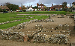
Caister's history dates back to Roman times. In around AD 200 a fort was built here as a base for a unit of the Roman army and navy. However its role as a fort appears to have been reduced following the construction of the Saxon Shore fort at Burgh Castle on the southern side of the estuary in the latter part of the 3rd century. The name 'Caister' derives from the Anglo-Saxon word 'ceaster' meaning 'Roman fort'

In the 1950s, a building near the south gate at Caister was excavated in advance of a housing development. These buildings do not appear to be military as they include a hypocaust and painted wall plaster as well as female jewellery, and it has been suggested that this building may have been an officer's house, or possibly a ‘seamen's hostel’ which may be a polite name for a brothel. The site appears to have been abandoned in the 5th century, but 150 Saxon burials have been found to the south of the enclosure. [4] The remains excavated in the 1950s are now managed by English Heritage and are open free of charge to the public as Caister Roman Site.

There has been an offshore lifeboat in the area since 1791. [5] It was used by a beach company to salvage ships wrecked on the sand banks. Between 1856 and 1969 lifeboats were operated by the RNLI. In the 1901 Caister lifeboat disaster, nine crew were lost while attempting a rescue during heavy seas. At the time it was said, "If they had to keep at it 'til now, they would have sailed about until daylight to help her. Going back is against the rules when we see distress signals like that". [6] A monument to the men lost in the disaster bearing the inscription "Caister men never turn back" stands in the village cemetery, unveiled in 1903 and was listed Grade II by Historic England in 2020. [7] [8] A pub called the "Never Turn Back" is named after the incident.

Today, Caister is also host to a National Coastwatch Institution (NCI) Station.[ citation needed ]

21st century

There is a Haven caravan and holiday park near the coast. The oldest holiday camp in the UK, it began as the "Caister Socialist Camp" in 1906. [9] In the 1950s and early 1960s, it used to be on both sides of the road. Opposite the beach was a dining room, paper shop, sports facilities and tourist chalets. These facilities were sold to a property developer who turned it into housing in the 1970s. In the 1980s a brand new holiday camp was opened, under the ownership of Ladbrokes, which was later sold to Warners in the 1990s.

Caister’s village football team, Caister F.C., currently play at the King George V playing field.[ citation needed ]

War memorial

Related Research Articles

<span class="mw-page-title-main">East Anglia</span> Region of England

East Anglia is an area in the East of England. It comprises the counties of Norfolk and Suffolk, with Cambridgeshire and Essex also included in some definitions. The name derives from the Anglo-Saxon kingdom of the East Angles, a people whose name originated in Anglia, in what is now Northern Germany.

<span class="mw-page-title-main">Great Yarmouth</span> Seaside town in Norfolk, England

Great Yarmouth, often called Yarmouth, is a seaside town which gives its name to the wider Borough of Great Yarmouth in Norfolk, England; it straddles the River Yare and is located 20 miles (32 km) east of Norwich. Its fishing industry, mainly for herring, shrank after the mid-20th century and has all but ended. North Sea oil from the 1960s supplied an oil-rig industry that services offshore natural gas rigs; more recently, offshore wind power and other renewable energy industries have ensued.

<span class="mw-page-title-main">Gorleston-on-Sea</span> Town in England

Gorleston-on-Sea, historically and colloquially known as Gorleston, is a seaside town in the borough of Great Yarmouth in Norfolk, England. It lies to the south of Great Yarmouth, on the opposite side of the mouth of the River Yare. Historically in Suffolk, it was a port town at the time of the Domesday Book. It was incorporated into Great Yarmouth in 1836. Gorleston's port became a centre of fishing for herring along with salt pans used for the production of salt to preserve the fish. In Edwardian times the fishing industry rapidly declined and the town's role changed to that of a seaside resort.

<span class="mw-page-title-main">Filey</span> Seaside town and civil parish in North Yorkshire, England

Filey is a seaside town and civil parish in North Yorkshire, England. It is located between Scarborough and Bridlington on Filey Bay. Although it was a fishing village, it has a large beach and became a popular tourist resort. According to the 2011 UK census, Filey parish had a population of 6,981, in comparison to the 2001 UK census population figure of 6,819, and a population of 6,870 in 1991.

<span class="mw-page-title-main">Borough of Great Yarmouth</span> Non-metropolitan district and borough in England

The Borough of Great Yarmouth is a local government district with borough status in Norfolk, England. It is named after its main town, Great Yarmouth, and also contains the town of Gorleston-on-Sea and a number of villages and rural areas, including part of The Broads. Other notable settlements include Caister-on-Sea, Hemsby, Hopton-on-Sea and Winterton-on-Sea.

<span class="mw-page-title-main">Fakenham</span> Town and civil parish in Norfolk, England

Fakenham is a market town and civil parish in Norfolk, England. It is situated on the River Wensum, about 25 miles north-west of Norwich. The town is at the junction of several local roads, including the A148 from King's Lynn to Cromer, the A1067 to Norwich and the A1065 to Swaffham.

<span class="mw-page-title-main">Holiday camp</span>

A holiday camp is a type of holiday accommodation that encourages holidaymakers to stay within the site boundary, and provides entertainment and facilities for them throughout the day. Since the 1970s, the term has fallen out of favour with terms such as holiday park, resort, holiday village and holiday centre replacing it.

<span class="mw-page-title-main">Freshwater, Isle of Wight</span> Human settlement in England

Freshwater is a large village and civil parish at the western end of the Isle of Wight, England. The southern, coastal part of the village is Freshwater Bay, named for the adjacent small cove. Freshwater sits at the western end of the region known as the Back of the Wight or the West Wight, a popular tourist area.

<span class="mw-page-title-main">Corton, Suffolk</span> Human settlement in England

Corton is a village and civil parish in the north of the English county of Suffolk. It is 3 miles (4.8 km) north of the centre of Lowestoft in the East Suffolk district. The village is on the North Sea coast with the county border with Norfolk to the north. It is a seaside holiday centre, with a number of facilities for visitors. Great Yarmouth is 6 miles (9.7 km) to the north.

<span class="mw-page-title-main">Winterton-on-Sea</span> Human settlement in England

Winterton-on-Sea is a village and civil parish on the North Sea coast of the English county of Norfolk. It is 8 miles (13 km) north of Great Yarmouth and 19 miles (31 km) east of Norwich.

<span class="mw-page-title-main">West Caister</span> Human settlement in England

West Caister is a village and civil parish in the English county of Norfolk. It is situated just inland from the coast, some 2 km (1.2 mi) from the seaside resort of Caister-on-Sea and 4 km (2.5 mi) north of the town of Great Yarmouth.

Hemsby is a village, seaside resort and civil parish in the county of Norfolk, England. It is situated some 8 mi (13 km) north of the town of Great Yarmouth. In the 2001 census Hemsby had a population of 2,973 in 1,221 households; by the 2011 census it had increased to 3,275. Hemsby borders the villages of Winterton-on-Sea and Scratby. For the purpose of local government, the parish is in the district of Great Yarmouth.

<span class="mw-page-title-main">Mundesley</span> Human settlement in England

Mundesley /ˈmʌn.dzli/ is a coastal village and a civil parish in the English county of Norfolk. The village is 20.3 miles (32.7 km) north-north east of Norwich, 7.3 miles (11.7 km) south east of Cromer and 136 miles (219 km) north east of London. The village lies 5.6 miles (9.0 km) north-north east of the town of North Walsham. The nearest railway station is at North Walsham, for the Bittern Line which runs between Sheringham and Norwich. The nearest airport is Norwich Airport. The village sits astride the B1159 coast road that links Cromer and Caister-on-Sea, and is at the eastern end of the B1145 a route which runs between King's Lynn and Mundesley. Mundesley is within the Norfolk Coast AONB. It has a resident population of around 2,695, measured at 2,758 in the 2011 Census. The River Mun or Mundesley Beck flows into the sea here. On 5 September 2022 Mundesley beach won the North Norfolk District Council Battle of the Beaches to be recognised as the top beach in North Norfolk in a close run off against West Runton beach.

<span class="mw-page-title-main">A149 road</span> Road in Norfolk, linking Kings Lynn and Great Yarmouth

The A149 is commonly known as "The Coast Road" to local residents and tourists, as this road runs along the North Norfolk coast from King's Lynn to Great Yarmouth, via coastal villages.

<span class="mw-page-title-main">Gariannonum</span> Roman fort in Norfolk, England

Gariannonum, or Gariannum, was a Roman Saxon Shore fort in Norfolk, England. The Notitia Dignitatum, a Roman Army "order of battle" from about AD 400, lists nine forts of the Saxon Shore in south and east England, among which one was called Gariannonor. It has been much discussed over the years in terms of spelling, purpose, and location. The fort is listed as being commanded by the Praepositus equitum stablesianorum, implying its garrison was a cavalry of a form originated in the late 3rd century, the Equites Stablesiani. Both proposed sites show archaeological evidence for military occupation beginning at around the time this type of unit began use.

<span class="mw-page-title-main">Caister-on-Sea railway station</span> Former railway station in Norfolk, England

Caister-on-Sea railway station is a former railway station in Caister-on-Sea, Norfolk, England. It was opened in 1877. It later became part of the Midland and Great Northern Joint Railway route from Birmingham to Great Yarmouth, predominantly used by holidaymakers. The station was a few miles north of the terminus at Yarmouth Beach. The station closed with the rest of the line in 1959. The station was demolished following closure and the site is now occupied by housing.

<span class="mw-page-title-main">1901 Caister lifeboat disaster</span> RNLI boat wrecked in the Great Storm

The Caister lifeboat disaster of 13 November 1901 occurred off the coast of Caister-on-Sea, Norfolk, England. It took place during what became known as the "Great Storm", which caused havoc down the east coasts of England and Scotland.

<span class="mw-page-title-main">Caister Volunteer Lifeboat Service</span> Lifeboat service in Norfolk, England

Caister Volunteer Lifeboat Service, or Caister Lifeboat, is based at Caister-on-Sea in Norfolk, and operates one of only three offshore lifeboats in the UK that are independent of the RNLI.

<span class="mw-page-title-main">Caister Roman Site</span> Roman Saxon Shore fort, located in Caister-on-Sea, Norfolk

Caister Roman Site is a Roman Saxon Shore fort, located in Caister-on-Sea, Norfolk, England. It was constructed around AD 200 for use by units of the Roman army and navy, and was occupied until around 370-390 AD. This fort was possibly known as Gariannonum, although the single record that describes it as such may also mean the Roman site at Burgh Castle.

<span class="mw-page-title-main">Charles Green (archaeologist)</span> English archaeologist

Charles Green (1901–1972) was an English archaeologist noted for his excavations in East Anglia, and his work on the Sutton Hoo ship-burial. His "signal achievements" were his East Anglian excavations, including four years spent by Caister-on-Sea and Burgh Castle, and several weeks in 1961 as Director of excavations at Walsingham Priory. Green additionally brought his "long experience of boat-handling" to bear in writing his 1963 book, Sutton Hoo: The Excavation of a Royal Ship-Burial, a major work that combined a popular account of the Anglo-Saxon burial with Green's contributions about ship-construction and seafaring.

References

  1. Office for National Statistics & Norfolk County Council (2001). Census population and household counts for unparished urban areas and all parishes . Retrieved 2 December 2005.
  2. "Parish population 2011" . Retrieved 24 August 2015.
  3. "Railway Passenger Stations in England, Scotland and Wales: A Chronology" by M E Quick; 2005.
  4. A Guide to the Roman Remains in Britain by Roger Wilson (Constable)
  5. BBC Online. Caister Lifeboat
  6. Storey, Neil R. (1 November 2011). Little Book of Norfolk. The History Press. ISBN   9780752494609.
  7. "Beauchamp Lifeboat Memorial, Caister-on-Sea, Caister-on-Sea - 1468694 | Historic England". historicengland.org.uk. Retrieved 26 December 2020.
  8. "Captivating Sites Across England Listed During 2020 | Historic England". historicengland.org.uk. 16 December 2020. Retrieved 26 December 2020.
  9. Holiday camps at Seaside History. Accessed May 2008.

http://kepn.nottingham.ac.uk/map/place/Norfolk/Caister%20next%20Yarmouth