South Norfolk

Last updated

South Norfolk District
Cmglee Wymondham Market Place.jpg
Market Place in Wymondham, the district's largest town.
South Norfolk UK locator map.svg
Shown within Norfolk
Sovereign state United Kingdom
Constituent country England
Region East of England
Administrative county Norfolk
Formed1 April 1974
Admin. HQBroadland Business Park near Norwich
Government
  TypeSouth Norfolk District Council
   MPs: Richard Bacon (C),
George Freeman (C),
Clive Lewis (L)
Area
  Total350.4 sq mi (907.6 km2)
  Rank 33rd
Population
 (2021)
  Total142,527
  Rank Ranked 157th
  Density410/sq mi (160/km2)
Ethnicity (2021)
[1]
   Ethnic groups
List
Religion (2021)
[1]
   Religion
List
Time zone UTC+0 (Greenwich Mean Time)
  Summer (DST) UTC+1 (British Summer Time)
ONS code 33UH (ONS)
E07000149 (GSS)

South Norfolk is a local government district in Norfolk, England. The largest town is Wymondham, and the district also includes the towns of Costessey, Diss, Harleston, Hingham, Loddon and Long Stratton. The council was based in Long Stratton until 2023 when it moved to the Broadland Business Park near Norwich, in the neighbouring Broadland district, as part of a shared facility with Broadland District Council. Some of the district's urban areas (including Costessey) form part of the Norwich built-up area. The district also includes numerous villages and surrounding rural areas. Some eastern parts of the district lie within The Broads.

Contents

The neighbouring districts are Breckland, Broadland, Norwich, Great Yarmouth, East Suffolk and Mid Suffolk.

History

The district was created on 1 April 1974 under the Local Government Act 1972, covering five former districts, which were all abolished at the same time: [2]

The new district was named South Norfolk, reflecting its position within the wider county. [3]

The council appointed a shared managing director with neighbouring Broadland District Council in 2018. The two councils' staff were merged in 2020 and the councils moved to a new shared building in 2023. [4] [5]

Governance

South Norfolk Council
South Norfolk Council logo.svg
Type
Type
Leadership
James Easter,
Conservative
since 23 May 2022 [6] [7]
John Fuller,
Conservative
since May 2007
Trevor Holden
since 2019 [8]
Structure
Seats46 councillors
Political groups
Administration (24)
  Conservative (24)
Other parties (15)
  Liberal Democrats (11)
  Labour (9)
  Independent (2)
Elections
Last election
4 May 2023
Next election
6 May 2027
Meeting place
The Horizon Centre, Broadland Business Park, Peachman Way, Norwich, NR7 0WF
Website
www.southnorfolkandbroadland.gov.uk

South Norfolk Council provides district-level services. County-level services are provided by Norfolk County Council. The whole district is also covered by civil parishes, which form a third tier of local government. [9] [10]

In the parts of the district within The Broads, town planning is the responsibility of the Broads Authority. The district council appoints one of its councillors to sit on that authority. [11]

Political control

The council has been under Conservative majority control since 2007.

The first election to the council was held in 1973, initially operating as a shadow authority alongside the outgoing authorities until the new arrangements took effect on 1 April 1974. Political control of the council since 1974 has been as follows: [12] [13]

Party in controlYears
Independent 1974–1976
No overall control 1976–1979
Conservative 1979–1987
No overall control 1987–1995
Liberal Democrats 1995–2007
Conservative 2007–present

Leadership

The leaders of the council since 2003 have been:

CouncillorPartyFromTo
Vivienne Clifford-Jackson [14] Liberal Democrats 2003May 2007
John Fuller [15] Conservative May 2007

Composition

Following the 2023 election the composition of the council was: [16]

PartyCouncillors
Conservative 24
Liberal Democrats 11
Labour 9
Independent 2
Total46

The next election is due in 2027.

Elections

Since the last full review of boundaries in 2019 the council has comprised 46 councillors representing 26 wards with each ward electing one, two or three councillors. Elections are held every four years. [17]

UK Youth Parliament

Although the UK Youth Parliament is an apolitical organisation, the elections are run in a way similar to that of the Local Elections. The votes come from 11 to 18 year olds and are combined to make the decision of the next, 2 year Member of Youth Parliament. The elections are run at different times across the country with South Norfolk's typically being in early Spring and bi-annually. [18] [19] [20]

Premises

In 2023 the council moved to the Horizon Centre, a modern office building at the Broadland Business Park on the outskirts of Norwich (in the parish of Postwick with Witton). The council shares the building with Broadland District Council as part of their joint management and staff arrangement. [21]

South Norfolk House, Long Stratton: Council's headquarters 1979-2023. South Norfolk Council Offices, Long Stratton - geograph.org.uk - 349860.jpg
South Norfolk House, Long Stratton: Council's headquarters 1979–2023.

Prior to 2023 the council was based at South Norfolk House at Cygnet Court in Long Stratton, which had been purpose-built for the council and was formally opened on 26 September 1979. [22]

Geography

South Norfolk population pyramid South Norfolk population pyramid.svg
South Norfolk population pyramid

At the time of the 2001 census, the district had an area of 909 km², with a population of 110,710 in 46,607 households. [23]

Towns and parishes

The district made up of 119 civil parishes. The parish councils for Costessey, Diss, Hingham, Loddon, Long Stratton, Redenhall with Harleston, and Wymondham have declared their parishes to be towns, allowing them to take the style "town council". [24]

Merger

In October 2020, Private Eye reported a total of £594,000 was paid to two managers leaving South Norfolk council as a result of the merger[ when? ] of the management teams at South Norfolk and Broadland councils, which included £540,000 to outgoing chief executive Sandra Dinneen. [25] (A further £357,000 in termination payments was to be shared between three managers leaving Broadland council due to the merger.) The councils stated these so-called "golden goodbyes" would save them money, as they would have fewer highly paid senior officials after they departed. [26]

In early 2023, South Norfolk District Council and Broadland District Council moved into a joint headquarters in the Broadland Business Park near Norwich. As a result of this move, South Norfolk District Council's headquarters no longer sits within the district. However, proponents of the move defend the decision, stating that due to the population density of the district being heavily weighted towards the greater Norwich suburbs, the new headquarters is more accessible to the majority of the district's residents than the previous headquarters in Long Stratton.

Arms

Coat of arms of South Norfolk
Notes
Granted 23 July 1979. [27]
Crest
On a wreath of the colours a demi-boar Ermine langued Gules between two wings addorsed Argent resting the sinister hoof upon a hexagon Or enclosing a mullet Azure.
Escutcheon
Per chevron lozengy Argent and Vert and barry wavy of six Azure and Argent in chief two garbs and in the fess point a hexagon [voided] Or.
Motto
Service Without Prejudice

Related Research Articles

<span class="mw-page-title-main">Broadland</span> Non-metropolitan district in England

Broadland is a local government district in Norfolk, England, named after the Norfolk Broads. Its council is based at the Broadland Business Park on the outskirts of Norwich. The district includes the towns of Aylsham, Reepham, Sprowston and Thorpe St Andrew. Several of the district's settlements form part of the Norwich built-up area, lying outside the city's boundaries to the north-west and north-east. The district also includes numerous villages and surrounding rural areas. Some eastern parts of the district lie within The Broads.

<span class="mw-page-title-main">Breckland District</span> Non-metropolitan district in England

Breckland is a local government district in Norfolk, England. Its council is based in Dereham, although the largest town is Thetford. The district also includes the towns of Attleborough, Swaffham and Watton, along with numerous villages and surrounding rural areas.

<span class="mw-page-title-main">Diocese of Norwich</span> Diocese of the Church of England

The Diocese of Norwich is an ecclesiastical jurisdiction or diocese of the Church of England that forms part of the Province of Canterbury in England.

<span class="mw-page-title-main">Mid Norfolk (UK Parliament constituency)</span> Parliamentary constituency in the United Kingdom, 1885-1918 & 1983 onwards

Mid Norfolk is a constituency represented in the House of Commons of the UK Parliament since 2010 by George Freeman, a Conservative.

<span class="mw-page-title-main">South Norfolk (UK Parliament constituency)</span> Parliamentary constituency in the United Kingdom, 1868 onwards

South Norfolk is a constituency represented in the House of Commons of the UK Parliament since 2001 by Richard Bacon, a Conservative.

<span class="mw-page-title-main">Long Stratton</span> Town in Norfolk

Long Stratton is a town and civil parish in Norfolk, England. It historically consisted of two villages; the larger, Stratton St. Mary, is to the south, and the other, Stratton St. Michael, is to the north. It had a population of 4,424 in the 2011 Census. South Norfolk Council are based in the town.

The civil parish of Tharston and Hapton lies in the south of the county of Norfolk, England. It encompasses the two villages of Tharston and Hapton, covering 9.26 km2 (3.58 sq mi). The parish had a population of 599 in 231 households at the 2001 census, increasing to 793 at the 2011 census.

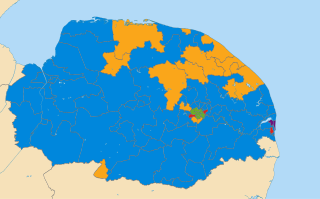
South Norfolk District Council in Norfolk, England is elected once every four years. Since the last boundary changes in 2007, 46 councillors have been elected from 36 wards.

<span class="mw-page-title-main">Forncett St Mary</span> Human settlement in England

Forncett St Mary is a village and former civil parish, now in the parish of Forncett, in the South Norfolk district, in the county of Norfolk, England. The village is located 7.4 miles (11.9 km) east of Attleborough and 10 miles (16 km) south-west of Norwich, close to the course of the River Tas. In 1931 the parish had a population of 153.
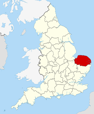
<span class="mw-page-title-main">Gillingham, Norfolk</span> Human settlement in England

Gillingham is a small village and civil parish in the English county of Norfolk. The villages is located 1.5 miles (2.4 km) north-west of Beccles and 15 miles (24 km) south-east of Norwich, along the A146 between Norwich and Lowestoft.

<span class="mw-page-title-main">2009 Norfolk County Council election</span>

The Norfolk County Council election took place on 4 June 2009, coinciding with local elections for all county councils in England.

<span class="mw-page-title-main">Redenhall with Harleston</span> Human settlement in England

Redenhall with Harleston is a civil parish in the South Norfolk district of the English county of Norfolk, comprising the town of Harleston and the neighbouring village of Redenhall. It covers an area of 13.73 km2 (5.30 sq mi), and had a population of 4,058 in 1,841 households at the 2001 census, the population increasing to 4,640 at the 2011 census.

<span class="mw-page-title-main">Great Moulton</span> Human settlement in England

Great Moulton is a civil parish in the English county of Norfolk. Until the 16th century it also included the Little Moulton parish.

The East Anglian League was a football league in the East Anglia region of England.

<span class="mw-page-title-main">2011 South Norfolk District Council election</span>

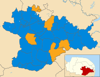
The elections to South Norfolk District Council were held on Thursday 5 May 2011 along with various other local elections around England, elections to the Scottish Parliament, National Assembly of Wales and Northern Ireland Assembly, and a referendum on whether to adopt the Alternative Vote electoral system for elections to the House of Commons. All 46 council seats were up for election. The previous council was controlled by the Conservatives, with the Liberal Democrats being the only opposition.

<span class="mw-page-title-main">Harleston, Norfolk</span> Human settlement in England

Harleston is a town 16 miles (26 km) from Norwich, in the civil parish of Redenhall with Harleston, in the South Norfolk district, in the county of Norfolk, England. In 2018 it had an estimated population of 5067. Harleston is on the Norfolk/Suffolk border, close to the River Waveney. Harleston has 2 markets every Wednesday.

References

  1. 1 2 UK Census (2021). "2021 Census Area Profile – South Norfolk Local Authority (E07000149)". Nomis. Office for National Statistics . Retrieved 5 January 2024.
  2. "The English Non-metropolitan District (Definition) Order 1972", legislation.gov.uk , The National Archives, SI 1972/2039, retrieved 17 November 2023
  3. "The English Non-metropolitan Districts (Names) Order 1973", legislation.gov.uk , The National Archives, SI 1973/551, retrieved 31 May 2023
  4. "Broadland District Council and South Norfolk Council" . Retrieved 5 December 2023.
  5. "Broadland and South Norfolk councils set to move into old Aviva office". BBC News. 18 May 2023. Retrieved 5 December 2023.
  6. "Council minutes, 23 May 2022" (PDF). South Norfolk Council. Retrieved 10 December 2023.
  7. "Council minutes, 24 May 2023" (PDF). South Norfolk Council. Retrieved 10 December 2023.
  8. Bunn, Jon (5 October 2018). "Holden to leave Luton for joint district role". Local Government Chronicle. Retrieved 5 December 2023.
  9. "Local Government Act 1972", legislation.gov.uk , The National Archives, 1972 c. 70, retrieved 31 May 2023
  10. "Election Maps". Ordnance Survey. Retrieved 21 September 2023.
  11. "Who we are". Broads Authority. Retrieved 6 December 2023.
  12. "Compositions calculator". The Elections Centre. 4 March 2016. Retrieved 1 June 2023.
  13. "South Norfolk". BBC News Online . Retrieved 17 March 2010.
  14. Thompson, George (30 March 2022). "Long-serving councillor resigns due to ill health". Eastern Daily Press. Retrieved 25 June 2022.
  15. Thompson, George (24 May 2022). "Council leader reappointed for his 16th year". Eastern Daily Press. Retrieved 25 June 2022.
  16. "Local elections 2023: live council results for England". The Guardian.
  17. "The South Norfolk (Electoral Changes) Order 2017", legislation.gov.uk , The National Archives, SI 2017/1082, retrieved 10 December 2023
  18. "Members of Youth Parliament - Norfolk County Council". norfolk.gov.uk.
  19. "Your Norfolk -". yournorfolk.norfolkpublications.org.uk.
  20. Cope, Lauren. "Norfolk's four new Members of Youth Parliament are announced". Eastern Daily Press.
  21. "Broadland and South Norfolk councils set to move into old Aviva office". BBC News. 18 May 2023. Retrieved 6 December 2023.
  22. "Courage of council is praised". Diss Express. 28 September 1979. p. 1. Retrieved 10 December 2023.
  23. Office for National Statistics & Norfolk County Council (2001). Census population and household counts for unparished urban areas and all parishes Archived 11 February 2017 at the Wayback Machine . Retrieved 2 December 2005.
  24. "Parish and town councils". South Norfolk Council. Retrieved 10 December 2023.
  25. "Eastern Daily Press".
  26. Private Eye, Issue 1532, p. 21
  27. "East of England Region". Civic Heraldry of England. Retrieved 9 March 2021.

52°29′31″N1°13′52″E / 52.4920°N 1.2312°E / 52.4920; 1.2312