Rochford District

Last updated

Rochford District
Aerial View of Rochford - geograph.org.uk - 2176414.jpg
Rochford, the administrative centre and one of the towns of the district
Rochford UK locator map.svg
Rochford shown within Essex
Sovereign state United Kingdom
Constituent country England
Region East of England
Non-metropolitan county Essex
Status Non-metropolitan district
Admin HQ Rochford
Incorporated1 April 1974
Government
  TypeNon-metropolitan district council
  BodyRochford District Council
  LeadershipAlternative - Sec. 31 (Liberal Democrats / Rochford Residents / Independent / Green)
   MPs James Duddridge
Mark Francois
Area
  Total65.44 sq mi (169.49 km2)
  Rank156th (of 296)
Population
 (2021)
  Total86,186
  Rank273rd (of 296)
  Density1,300/sq mi (510/km2)
  Ethnicity
96.5% White
1.2% S.Asian
Time zone UTC0 (GMT)
  Summer (DST) UTC+1 (BST)
ONS code 22UL (ONS)
E07000075 (GSS)
OS grid reference TQ876904

Rochford is a local government district in Essex, England. It is named after one of its main settlements, Rochford, where the council is based. The largest town in the district is Rayleigh. Other places in the district include Hockley, Ashingdon, Great Wakering, Canewdon and Hullbridge. The district wraps around the north of the city of Southend-on-Sea, with Southend Airport falling within the district. 
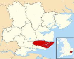
Most of the built-up areas are in the west of the district along the Shenfield to Southend Victoria railway. The eastern part of the district is more sparsely populated and has a stretch of coast at Foulness Island.

Contents

The neighbouring districts are Southend-on-Sea, Castle Point, Basildon, Chelmsford and Maldon.

History

The district was formed on 1 April 1974 under the Local Government Act 1972, covering the whole area of two former districts, which were abolished at the same time: [1] [2]

Governance

Rochford District Council
Rochford District Council logo.svg
Type
Type
Leadership
Jack Lawmon,
Independent
since 23 May 2023
John Mason,
Rochford Residents
since 23 May 2023
Jonathan Stephenson
since 1 August 2021 [3]
Structure
Seats39
Political groups
Administration (24)
  Liberal Democrats (9)
  Rochford Residents (7)
  Independent (7)
  Green (1)
Opposition (15)
  Conservative (14)
  Independent (1)
Elections
Last election
4 May 2023
Next election
2024
Meeting place
Rochford District Council offices - geograph.org.uk - 923338.jpg
Council Offices, South Street, Rochford, SS4 1BW
Website
www.rochford.gov.uk

Rochford District Council provides district-level services. County-level services are provided by Essex County Council. The district is also entirely covered by civil parishes, which form a third tier of local government. [4]

Rayleigh, one of the towns of the district and its largest settlement Rayleigh Windmill - geograph.org.uk - 2935459.jpg
Rayleigh, one of the towns of the district and its largest settlement

Political control

The council has been under no overall control since the 2023 election, being led by a coalition of the Liberal Democrats, Rochford Residents, Green Party and independents. [5] [6]

The first election to the council was held in 1973, initially operating as a shadow authority alongside the outgoing authorities until the new arrangements came into effect on 1 April 1974. Political control of the council since 1974 has been as follows: [7]

Party in controlYears
No overall control 1974–1976
Conservative 1976–1990
No overall control 1990–1994
Liberal Democrats 1994–1998
No overall control 1998–2002
Conservative 2002–2023
No overall control [8] 2023–present

Leadership

The leaders of the council since 2004 have been: [9]

CouncillorPartyFromTo
Terry Cutmore Conservative 22 Jun 200414 May 2019
Mike Steptoe Conservative 14 May 20199 Jul 2020
Simon Wootton Conservative 9 Jul 202023 May 2023
John Mason Rochford Resident 23 May 2023

Composition

Following the 2023 election, the composition of the council was: [10]

PartyCouncillors
Conservative 14
Liberal Democrats 9
Independent 8
Rochford Resident 7
Green 1
Total39

Of the eight independent councillors, four form the "Independent and Green" group with the Green councillor, three form the "Rochford District Independents" group and the other does not belong to a group. [11] The next election is due in 2024.

Premises

The council has its main offices on South Street in Rochford. When the council was created it inherited the former Rochford Rural District Council's offices at Roche House, 7 South Street, Rochford and the former Rayleigh Urban District Council's offices at Barringtons, 2 Hockley Road, Rayleigh. Both buildings were converted houses. The council acquired other properties along South Street in Rochford and combined them with Roche House to form the council's headquarters. [12] The council used a modern extension to Barringtons in Rayleigh as an area office and civic suite, containing the council chamber, until 2023 when the building was closed. [13] [14]

Elections

Since the last boundary changes in 2016 the council has comprised 39 councillors representing 13 wards, with each ward electing three councillors. Elections are held three years out of every four for a third of the council at a time. Elections to Essex County Council are held in the fourth year of the cycle when there are no district council elections. [15]

Parishes

Hawkwell, one of the villages of the district Hawkwell, Essex - St.Marys Church.jpg
Hawkwell, one of the villages of the district

The district is divided into 14 civil parishes. The parish council for Rayleigh takes the style "town council". [16] [17]

Arms

Coat of arms of Rochford District
Notes
Granted 8 March 1975.
Crest
Issuant from an ancient crown Or a mount Vert thereon in front of a representation of Rayleigh windmill Proper a seaxe fesswise Proper.
Escutcheon
Chequy of twelve Or a rose Gules barbed and seeded proper charged with a like rose Argent barbed and seeded Proper and Gules a garb Or.
Supporters
On the dexter side a bull [guardant] Sable armed unguled and winged Or and sinister a wyvern Vert.
Motto
Our Heritage Our Future. [18]
Badge
A roundel barry dancetty of six Gules and Or a pale wavy Argent charged with two pallets wavy Azure.

Related Research Articles

<span class="mw-page-title-main">Rochford</span> Town in England

Rochford is a town and civil parish in the Rochford District in Essex, England, 3 miles (4.8 km) north of Southend-on-Sea, 43 miles (69 km) from London and 21 miles (34 km) from Chelmsford. At the 2011 census, the civil parish had a population of 8,471.

<span class="mw-page-title-main">Rayleigh, Essex</span> Town in Essex, England

Rayleigh is a market town and civil parish in the Rochford District in Essex, England; it is located between Chelmsford and Southend-on-Sea, 32 miles (51 km) east of central London. It had a population of 32,150 at the census in 2011.

<span class="mw-page-title-main">Castle Point</span> Non-metropolitan district and borough in England

Castle Point is a local government district with borough status in south Essex, England, lying 30 miles (48 km) east of central London. The borough comprises an area on the mainland and the adjoining Canvey Island in the Thames Estuary, which is connected to the mainland by bridges. The council is based in Thundersley. The borough's other main settlements are Canvey Island, Hadleigh and South Benfleet.

<span class="mw-page-title-main">Braintree District</span> Non-metropolitan district in England

Braintree District is a local government district in Essex, England. The district is named after its largest town, Braintree, where the council is based. The district also includes the towns of Halstead and Witham and surrounding rural areas.

<span class="mw-page-title-main">Borough of Brentwood</span> District in Essex, England

The Borough of Brentwood is a local government district with borough status in Essex, England. The borough is named after its main town of Brentwood, where the council is based; it includes several villages and the surrounding rural area.

Hockley is a large village and civil parish in Essex in the East of England located between Chelmsford and Southend-on-Sea, or, more specifically, between Rayleigh and Rochford. It came to prominence during the coming of the railway in the 1890s and at the 2001 census had a population of 13,616 people, reducing to 9,616 at the 2011 Census,. The parish of Hockley itself had a population of 8,909 at the, while the urban area runs into the neighbouring parish of Hawkwell. Hockley railway station serves the village.

<span class="mw-page-title-main">Rayleigh (UK Parliament constituency)</span> Parliamentary constituency in the United Kingdom, 1997–2010

Rayleigh was a parliamentary constituency in Essex represented in the House of Commons of the Parliament of the United Kingdom. It elected one Member of Parliament (MP) by the first past the post system of election from 1997 to 2010.

<span class="mw-page-title-main">Rochford and Southend East (UK Parliament constituency)</span> Parliamentary constituency in the United Kingdom, 1997 onwards

Rochford and Southend East is a constituency represented in the House of Commons of the UK Parliament since 2005 by Sir James Duddridge, a Conservative.

Rochford Rural District was a rural district with an area of 146.01 square kilometres in the county of Essex, England. It was created in 1894, in 1897 the parish of Leigh was removed to create the Leigh-on-Sea Urban District. In 1926 the parish of Canvey Island was removed to create the Canvey Island Urban District. In 1929 the parishes of Hadleigh, South Benfleet and Thundersley were removed to create the Benfleet Urban District, at the same time the parishes of Rayleigh and Rawreth were removed to create the Rayleigh Urban District.

<span class="mw-page-title-main">Ashingdon</span> Village and civil parish in Essex, England

Ashingdon is a village and civil parish in Essex, England. It is located about 3 miles (4.8 km) north of Rochford and is 13 miles (21 km) southeast of Chelmsford. The village lies within Rochford District and the parliamentary constituency of Rayleigh.

<span class="mw-page-title-main">Hullbridge</span> Human settlement in England

Hullbridge is a village and civil parish in the Rochford district of Essex in England. Bordered to the north by the River Crouch, as well a distance from Hockley and Rayleigh. Hullbridge had a population of 6,527 at the Census 2011.

<span class="mw-page-title-main">Rayleigh and Wickford (UK Parliament constituency)</span> Parliamentary constituency in the United Kingdom, 2010 onwards

Rayleigh and Wickford is a constituency represented in the House of Commons of the UK Parliament since its 2010 creation by Mark Francois, a Conservative.

<span class="mw-page-title-main">Eastwood, Essex</span> Human settlement in England

Eastwood is a suburb of the city of Southend-on-Sea, in the ceremonial county of Essex, England. Eastwood is sometimes called Eastwood Park, particularly for local elections. It was formerly a civil parish, the main part of which was absorbed into the municipal borough of Southend-on-Sea in 1933.

<span class="mw-page-title-main">County Borough of Southend on Sea</span>

Southend-on-Sea is a local government district around the seaside resort of Southend-on-Sea in Essex, England. Its origin was a local board formed for the parish of St John the Baptist, which had been split off from Prittlewell for ecclesiastical purposes in 1842. It was incorporated as a municipal borough in 1892. In 1889, when Essex County Council was formed, Southend-on-Sea was within the administrative county of Essex. However, through expansion in area and population by 1914 it was split off from the administrative county as a county borough. The local authority was Southend Local Board from 1886 and Southend Corporation from 1892. The corporation changed the name of the town from Southend to Southend-on-Sea in 1893. In 1974 the county borough was reconstituted as a non-metropolitan district with the same boundaries and some powers were transferred to Essex County Council. On 1 April it became a unitary authority area thus independent of Essex County Council again but still in the ceremonial county of Essex.

<span class="mw-page-title-main">Arriva Southend</span> Bus operator in Southend-on-Sea, Essex

Arriva Southend is a division of Arriva Southern Counties, a subsidiary of transport group Arriva which operates bus services in and around the Southend-on-Sea, Rochford, Rayleigh areas of Essex. They operate most services east of Southend and a few services west of Southend, and compete to a limited extent with three other local operators with services in the same areas: First Essex, NIBS and Stephensons of Essex.

<span class="mw-page-title-main">Rochford (UK Parliament constituency)</span> Parliamentary constituency in the United Kingdom, 1983–1997

Rochford was a County Constituency in Essex, represented in the House of Commons of the Parliament of the United Kingdom from 1983 until 1997. It elected one Member of Parliament (MP) by the first past the post system of election.

<span class="mw-page-title-main">Canewdon</span> Village and civil parish in Essex, England

Canewdon is a village and civil parish in the Rochford district of Essex, England. The village is located approximately 4 miles (6.4 km) northeast of the town of Rochford, while the parish extends for several miles on the southern side of the River Crouch.

<span class="mw-page-title-main">Southend-on-Sea City Council</span> Local authority of Southend-on-Sea, Essex, England

Southend-on-Sea City Council is the local authority of the Southend-on-Sea district in Essex, England. It is a unitary authority, having the powers of a non-metropolitan county and district council combined. It is a member of the East of England Local Government Association. It is based at Southend Civic Centre in Southend-on-Sea.

References

  1. "The English Non-metropolitan Districts (Definition) Order 1972", legislation.gov.uk , The National Archives, SI 1972/2039, retrieved 31 May 2023
  2. "The English Non-metropolitan Districts (Names) Order 1973", legislation.gov.uk , The National Archives, SI 1973/551, retrieved 31 May 2023
  3. Ferris, Mick (29 July 2021). "Joint chief executive appointed to oversee Brentwood and Rochford councils". Yellow Advertiser. Retrieved 8 June 2023.
  4. "Local Government Act 1972", legislation.gov.uk , The National Archives, 1972 c. 70, retrieved 31 May 2023
  5. "New Council administration appointed". Rochford District Council. Retrieved 7 June 2023.
  6. Dedman, Simon (24 May 2023). "Colchester: Power-sharing ends between Labour and Lib Dems". BBC News. Retrieved 7 June 2023.
  7. "Compositions calculator". The Elections Centre. Retrieved 1 June 2023.
  8. Dedman, Simon (24 February 2023). "Tories lose control of council after three quit". BBC News. Retrieved 27 February 2023.
  9. "Council minutes". Rochford District Council. Retrieved 26 May 2022.
  10. "Local elections 2023: live council results for England". The Guardian.
  11. "Council meeting, 23 May 2023". Rochford District Council. Retrieved 8 June 2023.
  12. "Rochford Conservation Area Appraisal and Management Plan". Rochford District Council. April 2006. Retrieved 8 June 2023.
  13. Emes, Toby (12 October 2021). "Protest held over plans to build on Civic Suite, Rayleigh". Southend Echo. Retrieved 8 June 2023.
  14. "Council's Rayleigh reception moves to Mill Arts and Events Centre". Rochford District Council. Retrieved 8 June 2023.
  15. "The Rochford (Electoral Changes) Order 2015", legislation.gov.uk , The National Archives, SI 2015/1860, retrieved 8 June 2023
  16. "Parish and Town Council Clerks". Rochford District Council. Retrieved 8 June 2023.
  17. "Election Maps". Ordnance Survey. Retrieved 8 June 2023.
  18. "East of England Region". Civic Heraldry of England. Retrieved 9 March 2021.

51°34′54″N0°42′30″E / 51.5817°N 0.7082°E / 51.5817; 0.7082