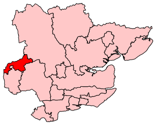
Pincey Brook is a watercourse in the Uttlesford and Epping Forest districts of Essex, England, and is a tributary to the River Stort.
Contents

Pincey Brook is a watercourse in the Uttlesford and Epping Forest districts of Essex, England, and is a tributary to the River Stort.
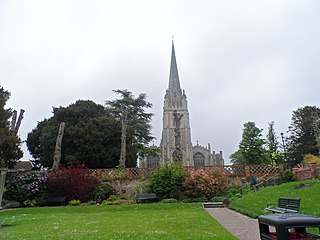
Pincey Brook rises at the south-east edge of London Stansted Airport, just north from the A120 road, and in the civil parish of Takeley. It runs south through Hatfield Broad Oak parish, passing the hamlet of Bush End, and, further south, Hatfield Broad Oak village at its western edge, afterwards turning south-west to become part of the parish boundary with Hatfield Heath. Curving further towards the west through Hatfield Heath parish, it becomes the northern boundary of the Down Hall Estate. For 700 yards (640 m) beyond the western edge of the Estate, it becomes the parish boundary between Hatfield Heath and Matching, before flowing into Sheering parish for 800 yards (730 m), after which it becomes the parish boundary between Matching and Sheering, this for 1500 yards (1,400 m), and to the M11 motorway. A culvert takes the Brook under the motorway, after which it remains in Sheering until 550 yards (500 m) from the north-east edge of Gibberd Garden. From here the Brook becomes the boundary between Sheering and the Essex town of Harlow at Elim Meadows, until it flows into the River Stort at a triangulation with Sawbridgeworth parish in Hertfordshire. The total length is approximately 13.5 miles (22 km). [1] [2] [3] [4] [5]
Between 1999 and 2003, during Stansted Airport expansion, evidence was found of Middle Bronze Age settlement close to Pincey Brook. [6]
A sport mare, born 1985, was named 'Pincey Brook'. [7]
In 2013, a study was reported in the journal Limnologica - Ecology and Management of Inland Waters, concerning the probability of the incipient invasiveness of signal crayfish within the River Stort catchment area, including Pincey Brook. [8]

Hertfordshire is a ceremonial county in the East of England and one of the home counties. It borders Bedfordshire to the north-west, Cambridgeshire to the north-east, Essex to the east, Greater London to the south and Buckinghamshire to the west. The largest settlement is Watford, and the county town is Hertford.

Hertford is the county town of Hertfordshire, England, and is also a civil parish in the East Hertfordshire district of the county. The parish had a population of 26,783 at the 2011 census.

Bishop's Stortford is a historic market town in the London commuter belt. Located in Hertfordshire near the border with Essex, just west of the M11 motorway and Stansted Airport, it is 22 miles north-east of Central London and 34 minutes away by rail from Liverpool Street station. The town had an estimated population of 41,088 in 2020. The district of East Hertfordshire, where the town centre is located, has been ranked as the best place to live in the UK by the Halifax Quality of Life annual survey in 2020. The town is commonly known as Stortford by locals.
Uttlesford is a local government district in Essex, England. Its council is based in the town of Saffron Walden. The district also includes the town of Great Dunmow and numerous villages, including Stansted Mountfitchet, Takeley, Elsenham, Thaxted, and Newport. The district covers a largely rural area in the north-west of Essex. London Stansted Airport lies within the district.

Hertsmere is a local government district with borough status in Hertfordshire, England. Its council is based in Borehamwood. Other settlements in the borough include Bushey, Elstree, Radlett and Potters Bar. The borough contains several film studios, including Elstree Studios and the BBC Elstree Centre at Borehamwood. The borough borders Three Rivers, Watford, St Albans, and Welwyn Hatfield in Hertfordshire and the three north London boroughs of Harrow, Barnet and Enfield. Hertsmere is located mainly within the M25 Motorway.

East Hertfordshire is one of ten local government districts in Hertfordshire, England. Its council is based in Hertford, the county town of Hertfordshire. The largest town in the district is Bishop's Stortford, and the other main towns are Ware, Buntingford and Sawbridgeworth. At the 2011 Census, the population of the district was 137,687. By area it is the largest of the ten local government districts in Hertfordshire. The district borders North Hertfordshire, Stevenage, Welwyn Hatfield and Broxbourne in Hertfordshire, and Epping Forest, Harlow and Uttlesford in Essex.

Sawbridgeworth is a town and civil parish in Hertfordshire, England, close to the border with Essex. It is 12 miles (19 km) east of Hertford and 9 miles (14 km) north of Epping. It is the northernmost part of the Greater London Built-up Area.

Epping Forest District is a local government district in Essex, England. It is named after the ancient woodland of Epping Forest, a large part of which lies within the district. The district covers northeastern parts of the urban area of London, including the suburban towns of Epping, Loughton, Waltham Abbey, Chigwell, and Buckhurst Hill, as well as rural areas beyond it. The district is situated in the west of the county, bordering north-eastern Greater London.

The Stort Navigation is the canalised section of the River Stort running 22 kilometres (14 mi) from the town of Bishop's Stortford, Hertfordshire, downstream to its confluence with the Lee Navigation at Feildes Weir near Rye House, Hoddesdon, Hertfordshire.

St Albans is a constituency represented in the House of Commons of the UK Parliament since 2019 by Daisy Cooper, a Liberal Democrat.
Harlow is a constituency represented in the House of Commons of the UK Parliament since 2010 by Robert Halfon, a Conservative.

Little Hallingbury is a small village and a civil parish in the Uttlesford district of Essex, England.

The A120 is an A-road in England, which runs between Puckeridge in Hertfordshire and Harwich in Essex.

Matching is a village and civil parish in the Epping Forest district of Essex, England centred in countryside 3 miles (4.8 km) east of Harlow's modern town centre and 2 miles (3.2 km) from Old Harlow/Harlow Mills area of the town. The terrain is elevated and London is centred 21.7 miles (34.9 km) to the south-west.

Hatfield Heath is a village, civil parish, and an electoral ward in the Uttlesford district of Essex, England, and at its west is close to the border with Hertfordshire. In close proximity are the towns of Bishop's Stortford and Sawbridgeworth. Stansted Airport is approximately 5 miles (8 km) to the north.
Harlow District Council is the local authority for Harlow in Essex, England. Harlow is a non-metropolitan district, covering just the town of Harlow itself. The council generally styles itself Harlow Council.

The Hundred Parishes is an area of the East of England with no formal recognition or status, albeit that the concept has the blessing of county and district authorities. It encompasses around 450 square miles of northwest Essex, northeast Hertfordshire and southern Cambridgeshire. The area comprises just over 100 administrative parishes, hence its name. It contains over 6,000 listed buildings and many conservation areas, village greens, ancient hedgerows, protected features and a historical pattern of small rural settlements in close proximity to one another.

Newman's End is a hamlet in the civil parish of Matching, and the Epping Forest district of Essex, England.

The Three Forests Way is a long-distance footpath in Essex and Hertfordshire, England. The 59-mile (95 km) circular path passes through three forests in west Essex. It is waymarked, and named on Ordnance Survey mapping.
| Unitary authorities | |
|---|---|
| Boroughs or districts | |
| Major settlements (cities in italics) |
|
| Rivers | |