A120 road

Last updated

UK road A120.svg
A120
Route of A120.png
Route of the A120 from OpenStreetMap
Route information
Part of Tabliczka E32.svg E32
Major junctions
West end Puckeridge
Major intersectionsUK road A10.svg A10
UK road A1184.svg A1184
UK road A1250.svg A1250
UK-Motorway-M11.svg M11 Junctions 8 and 8A
UK road A131.svg A131
UK road A12.svg A12 Junctions 25 and 29
UK road A1232.svg A1232
UK road A133.svg A133
UK road A136.svg A136
East end Harwich
Location
Country United Kingdom
Primary
destinations
Stansted Airport
Colchester
Road network
UK road A119.svg A119 UK road A121.svg A121

The A120 is an A-road in England, which runs between Puckeridge in Hertfordshire and Harwich in Essex.

Contents

Along its route, the A120 bypasses the towns of Bishop's Stortford, Great Dunmow, Braintree, Coggeshall, Colchester and Dovercourt. The route meets the A10, A131, A12 and A133 primary routes and the M11 motorway. London Stansted Airport sits directly north of the route on the Essex and Hertfordshire border. Harwich International Port, a North Sea seaport at the mouth of the River Stour, lies north of the A120 near Harwich. [1]

Part of the route constitutes Euroroute E32, between the A12 (E30) at Colchester and Harwich International Port. [2]

Route

Hertfordshire

At its western terminus, the A120 meets the A10 at a roundabout south-west of Puckeridge. The A10 runs southbound towards Hertford and London, and northbound towards Royston and Cambridge.

Carried by Standon Hill, the A120 passes along the southern perimeter of Puckeridge and into the village of Standon. The route then continues towards Little Hadham, which it bypasses to the north, before reaching a roundabout with the A1184 and A1250 to the west of Bishop's Stortford. The town is bypassed to the north by the A120, crossing the River Stort and entering the county of Essex.

The route is managed by Hertfordshire County Council. [3]

Essex

Birchanger Green service station at M11 motorway junction 8 (with the A120) Birchanger Green Services - geograph.org.uk - 3395049.jpg
Birchanger Green service station at M11 motorway junction 8 (with the A120)

Entering Essex to the north of Bishop's Stortford and south of Stansted Mountfitchet, the A120 meets the B1383 Stansted Road at a roundabout. The route continues to bypass the north-eastern portion of Bishop's Stortford before meeting the A1250 Dunmow Road, then the M11 motorway at junction 8. The motorway runs southbound towards Harlow and London, and northbound towards Newmarket and Cambridge. Birchanger Green service station is accessed from the junction 8 roundabout. The roundabout also provides access to the B1256 towards Takeley and Little Canfield.

East of the M11 motorway, the A120 carries traffic to Priory Wood Roundabout. The roundabout provides direct access to the M11 motorway southbound, which joins the main carriageway at junction 8A, and to Round Coppice Road (northbound to Stansted Business Park, Stansted Mountfitchet and Elsenham). Direct access to the A120 eastbound is provided from the M11 northbound at junction 8A, on a carriageway which passes over the top of Priory Wood Roundabout (and vice versa for A120 westbound/M11 southbound traffic).

The A120 as viewed from an aeroplane landing at London Stansted Airport Landing over the A120 at Stansted - geograph.org.uk - 421367.jpg
The A120 as viewed from an aeroplane landing at London Stansted Airport

A dual carriageway carries the A120 to Braintree, past Great Dunmow, with grade-separated junctions:

The dual carriageway is broken at Galleys Corner, a roundabout with the B1018 (southbound to Witham), Cressing Road and Long Green. The roundabout sits to the south-east of Braintree. Access to Braintree Village, a shopping area, and Braintree Freeport railway station is via the B1018.

The A120 runs north–south along the eastern edge of Braintree town before reaching Marks Farm Roundabout. The north–south route continues as the A131 towards Halstead, Haverhill and Sudbury. Westbound from Marks Farm, the B1256 Coggeshall Road carries traffic into Braintree. The A120 resumes its east–west route along a single carriageway – which bypasses Coggeshall to the north – to Marks Tey.

At Marks Tey, the A12 meets the A120 at junction 25. The A12 runs southbound towards Kelvedon, Witham, Chelmsford and London, and northbound towards Colchester, Ipswich and Felixstowe. Marks Tey railway station, on the Great Eastern Main Line between London and Norwich, lies directly north-west of the junction.

A gap in the A120 is plugged by the A12 junctions 25–29, which runs to the north-west of Colchester.

The remainder of the A120 sits to the east of the A12 between Colchester and Harwich, meeting the London to Ipswich road at junction 29. At the junction, the A120 also meets A1232 Ipswich Road (southbound into Colchester). Along this section of the route, the A120 bypasses Elmstead, Wix, Ramsey and Dovercourt.

The A133 meets the A120 at a junction between Elmstead and Wix, which carries traffic towards Great Bentley, Weeley and Clacton-on-Sea.

Through the Dovercourt and Harwich towns, the B1352 runs roughly parallel to the A120. The B1352 meets the A120 at a roundabout near Ramsey and at the route's eastern terminus near Harwich Quay.

Harwich International Port, one of the A120's destinations Harwich International Port.jpg
Harwich International Port, one of the A120's destinations

The A120 runs along the northern edge of both towns, meeting the A136 Parkeston Bypass for access to Harwich International Port and Harwich International railway station. The route then continues eastbound towards Harwich town centre and Harwich Navyard, past the Dovercourt and Harwich Town railway stations which lie directly south-east of the route.

The eastern terminus of the A120 is a roundabout with the B1352 West Street and The Quay. Navyard lies east of the A120's eastern terminus.

Within Essex, Essex County Council manages the A120 west of the M11 motorway, near Bishop's Stortford. National Highways is responsible for the remainder of the route. [4] [5]

History

According to the Society for All British and Irish Road Enthusiasts (SABRE), the Ministry of Transport's 1922 List of Class I and Class II Roads and Numbers listed the A120 as being the route Puckeridge – Bishop's Stortford – Great Dunmow – Braintree – Marks Tey. [6]

Stane Street

The A120 roughly follows the path of the Stane Street Roman Road.

At its western end, Stane Street met Ermine Street, which ran north–south between Londinium (London), Lindum Colonia (Lincoln) and Eboracum (York). In the east, Stane Street's terminus was at Camulodunum (Colchester). [7] [8]

Archaeologists have uncovered Roman artefacts at several A120 towns.

In 2022, archaeologists unearthed Roman graves and evidence of a Roman settlement at Bishop's Stortford. Oxford Archaeologists, leading the project, described as a "once-in-a-lifetime discovery" and said evidence suggests the site was a major transport and trading post in the East of England. [9]

Of Great Dunmow, a Heritage Gateway report notes:

"Excavations between 1968 and 1972 uncovered the remains of a minor Roman linear settlement located along Stane Street, extending over 2 to 3 acres occupied from the 1st century AD to the 4th century AD; a Roman cremation cemetery and possible shrine were discovered along with timber buildings. The settlement is considered to be a vicus." [10]

Of Braintree, a similar report reads:

"The site of a Roman settlement at Braintree. Material found here suggests an extensive pre-Roman settlement, which continued as a small Roman urban centre at the intersection of Roman roads through the 1st century and perhaps diminishing in the 2nd, 3rd and 4th centuries." [11]

Bypasses

The A120 bypasses several towns and villages. These include:

Economy

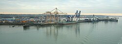
The A120 passes UK "international gateways" at London Stansted Airport and Harwich International Port. Connecting roads link the A120 with other UK gateways, such as the A12 towards Felixstowe and the M11 towards London. Since 2010, organisations including National Highways, A120 Driving Economic Growth and Transport East have identified the "A120 corridor" as one which supports UK government's economic ambitions such as growth and "levelling up". [14] [15] [16]

Related Research Articles

<span class="mw-page-title-main">M11 motorway</span> Motorway in England

The M11 is a 55-mile-long (89 km) motorway that runs north from the North Circular Road (A406) in South Woodford to the A14, northwest of Cambridge, England. Originally proposed as a trunk road as early as 1915, various plans were considered throughout the 1960s, with final construction being undertaken between 1975 and 1980. The motorway was opened in stages, with the first stage between junctions 7 and 8 opening in June 1975, and the completed motorway becoming fully operational in February 1980. Running from Woodford to Girton, the motorway provides direct access to Harlow, Cambridge and since 2002, greatly improved access to London Stansted Airport.

<span class="mw-page-title-main">A14 road (England)</span> Major road in England

The A14 is a major trunk road in England, running 127 miles (204 km) from Catthorpe Interchange, a major intersection at the southern end of the M6 and junction 19 of the M1 in Leicestershire to the Port of Felixstowe, Suffolk. The road forms part of the unsigned Euroroutes E24 and E30. It is the busiest shipping lane in East Anglia carrying anything from cars to large amounts of cargo between the UK and Mainland Europe.

<span class="mw-page-title-main">A12 road (England)</span> Road in England

The A12 is a major road in Eastern England. It runs north-east/south-west between London and the coastal town of Lowestoft in the north-eastern corner of Suffolk, following a similar route to the Great Eastern Main Line until Ipswich. A section of the road between Lowestoft and Great Yarmouth became part of the A47 in 2017. Between the junctions with the M25 and the A14, the A12 forms part of the unsigned Euroroute E30. Unlike most A roads, this section of the A12, together with the A14 and the A55, has junction numbers as if it were a motorway.

<span class="mw-page-title-main">N11 road (Ireland)</span> National primary road in Ireland

The N11 road is a national primary road in Ireland, running for 129 km (80 mi) along the east side of Ireland from Dublin to Wexford. It passes close to Bray, Greystones, Wicklow, Arklow, Gorey, and Enniscorthy. Beyond Wexford, the route continues to Rosslare as the N25. The road forms part of European route E01. As of July 2019 the N11/M11 is of dual carriageway or motorway standard from Dublin as far as Oilgate in County Wexford.

<span class="mw-page-title-main">Bishop's Stortford</span> Commuter town in Hertfordshire, England

Bishop's Stortford is a historic market town and civil parish in the East Hertfordshire district, in the county of Hertfordshire, England. It is in the London commuter belt, near the border with Essex, just west of the M11 motorway and Stansted Airport, 22 miles north-east of Central London and 34 minutes away by rail from Liverpool Street station. The town had an estimated population of 41,088 in 2020. The district of East Hertfordshire, where the town centre is located, was ranked as the best place to live in the UK by the Halifax Quality of Life annual survey in 2020.

<span class="mw-page-title-main">Great Dunmow</span> Town in Essex, England

Great Dunmow is a historic market town and civil parish in the Uttlesford district of Essex, England. It lies to the north of the A120 road, approximately midway between Bishop's Stortford and Braintree, 5 mi (8 km) east of London Stansted Airport.

<span class="mw-page-title-main">Uttlesford</span> Non-metropolitan district in England

Uttlesford is a local government district in Essex, England. Its council is based in the town of Saffron Walden. The district also includes the town of Great Dunmow and numerous villages, including Stansted Mountfitchet, Takeley, Elsenham, Thaxted, and Newport. The district covers a largely rural area in the north-west of Essex. London Stansted Airport lies within the district.

<span class="mw-page-title-main">A10 road (England)</span> Road in England

The A10 is a major road in England which runs between The City of London and King's Lynn in Norfolk.

<span class="mw-page-title-main">A11 road (England)</span> Road in England

The A11 is a major trunk road in England. It originally ran roughly north east from London to Norwich, Norfolk. It now consists of a short section in Inner London and a much longer section in Cambridgeshire, Suffolk and Norfolk. The lengthy section between these was renumbered as a result of the opening of the M11 in the 1970s and then the A12 extension in 1999.

<span class="mw-page-title-main">Takeley</span> Village in Essex, England

Takeley is a village and civil parish in the Uttlesford district of Essex, England.

<span class="mw-page-title-main">Marks Tey</span> Village in Essex, England

Marks Tey is a large village and electoral ward in Essex, England; it is located six miles west of Colchester. It is one in a group of villages called The Teys, including Great Tey and Little Tey.

<span class="mw-page-title-main">M15 motorway (Great Britain)</span> Cancelled road in the United Kingdom

The M15 motorway was the designation planned in the late 1960s and early 1970s for use on the North Circular Road (A406) after it had been upgraded to motorway standard. The upgrade was part of the London Ringways Plan to build motorways throughout London to ease congestion in the central area. Under the Ringways Plan, the North Circular Road was the northern section of Ringway 2.

<span class="mw-page-title-main">Bishop's Stortford railway station</span> Railway station in Hertfordshire, England

Bishop's Stortford railway station is on the West Anglia Main Line serving the town of Bishop's Stortford in Hertfordshire, England. It is 30 miles 27 chains (48.8 km) down the line from London Liverpool Street and is situated between Sawbridgeworth and Stansted Mountfitchet stations. Its three-letter station code is BIS. The station and all trains serving it are operated by Greater Anglia, including the half-hourly Stansted Express service.

<span class="mw-page-title-main">Stane Street (Colchester)</span> Roman road in England

Stane Street is a 39 mi (63 km) Roman road that runs from Ermine Street at Braughing, Hertfordshire to Colchester in Essex.

<span class="mw-page-title-main">A505 road</span> Road in southern England

The A505 is a road in the East of England. It follows part of the route of the Icknield Way and the corresponding Icknield Way Path and runs from Leighton Buzzard in Bedfordshire to the A11 Abington Interchange North in Cambridgeshire.

<span class="mw-page-title-main">M12 motorway (Great Britain)</span> Planned road in England

The M12 motorway was a planned motorway starting in north-east London and joining the A12 road in Essex. The 1960s scheme would have started at a junction with the M11 motorway and North Circular and ended near Brentwood, Chelmsford, or at the proposed new Maplin Sands airport; the motorway was part of the ambitious London Ringways plan to build motorways throughout London. Although most of the Ringways plan was cancelled in 1969 the M12 motorway project was still included in the Roads for Prosperity white paper published in 1989 along with major proposed developments to the A12 road. It was not formally cancelled until 30 March 1994 by the Secretary of State for Transport, John MacGregor.

<span class="mw-page-title-main">A130 road</span> Road in Essex, England

The A130 is a major road in England linking Howe Green, near Chelmsford, the county town of Essex, with Canvey Island in the south of that county. It is a primary route for some of its length, only losing that status south of the A13 junction at Sadlers Farm roundabout as it nears its terminus on Canvey Island. It was originally a much longer cross-country route.

<span class="mw-page-title-main">Braintree, Essex</span> Town in Essex, England

Braintree is a town in Essex, England, and is the principal settlement of Braintree District. It is located 10 miles (16 km) north-east of Chelmsford, 15 miles (24 km) west of Colchester and 35 miles (56 km) north-west of Southend-on-Sea. According to the 2021 Census, the town had a population of 43,492; the urban area, which includes Great Notley, Rayne, Tye Green and High Garrett, had a population of 55,793.

The Bishop's Stortford–Braintree branch line was an 18-mile-long (29 km) railway line connecting existing railways at Bishop's Stortford, Dunmow and Braintree. It was promoted independently by the Bishop’s Stortford, Dunmow and Braintree Railway (BSD&BR) company, but the directors failed to generate subscriptions, or to manage the construction properly. The Great Eastern Railway was the dominant railway company in the area, and saw the line as a blocker, to prevent the incursion of a rival line, so they felt obliged to support it. However they themselves had other pressing priorities, both managerial and financial, at the time, and for some time the construction was in abeyance.

Start Hill is a hamlet on the B1256 road, in the civil parish of Great Hallingbury, in the Uttlesford district, in the county of Essex, England. It is near the town of Bishop's Stortford.

References

  1. "OpenStreetMap". OpenStreetMap .
  2. "International E Road Network" (PDF). United Nations Economic Commission for Europe . 2007. Archived (PDF) from the original on 12 November 2022. Retrieved 15 January 2023.
  3. "Gazetteer of adopted roads". Hertfordshire County Council . Archived from the original on 15 January 2023. Retrieved 15 January 2023.
  4. "Highways Information Map". Essex County Council . Archived from the original on 15 January 2023. Retrieved 15 January 2023.
  5. "National Highways Strategic Road Network" (PDF). National Highways . Archived (PDF) from the original on 11 January 2023. Retrieved 15 January 2023.
  6. "1922 Road Lists/Zone 1 Class I". SABRE. Retrieved 15 January 2023.
  7. "Stane Street". OpenStreetMap . Archived from the original on 15 January 2023. Retrieved 15 January 2023.
  8. Davies, Hugh (2008). Roman Roads in Britain. Cheltenham: The History Press. ISBN   978-0752425030.
  9. Corr, Sinead (1 May 2022). "Archaeologists reveal Bishop's Stortford's past as a Roman 'new town' which sprung up around a transport interchange – the Roman equivalent of Birchanger Green M11 services". Bishop's Stortford Independent. Archived from the original on 15 January 2023. Retrieved 15 January 2023.
  10. "Historic England Research Records: Great Dunmow Roman Settlement". Heritage Gateway. Archived from the original on 15 January 2023. Retrieved 15 January 2023.
  11. "Historic England Research Records: Braintree Roman Settlement". Heritage Gateway. Archived from the original on 15 January 2023. Retrieved 15 January 2023.
  12. "A120 bypass (Little Hadham) and flood alleviation scheme". Hertfordshire County Council . Archived from the original on 15 January 2023. Retrieved 15 January 2023.
  13. "A120 Stansted to Braintree – Five Year After Study" (PDF). Gov.uk . January 2011. Archived from the original (PDF) on 27 November 2015. Retrieved 15 January 2023.
  14. "The Provision of Research Support for the International Gateway Study" (PDF). Department for Transport . 22 July 2016. Archived (PDF) from the original on 26 July 2019. Retrieved 15 January 2023.
  15. "A120 Driving Economic Growth". A120 Driving Economic Growth. Archived from the original on 5 July 2016.
  16. "Transport Strategy 2022" (PDF). Transport East. Archived (PDF) from the original on 21 November 2022. Retrieved 15 January 2023.

51°52′35″N0°40′26″E / 51.87626°N 0.67381°E / 51.87626; 0.67381