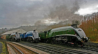
The North Yorkshire Moors Railway (NYMR) is a heritage railway in North Yorkshire, England, that runs through the North York Moors National Park. First opened in 1836 as the Whitby and Pickering Railway, the railway was planned in 1831 by George Stephenson as a means of opening up trade routes inland from the then important seaport of Whitby. The line between Grosmont and Rillington was closed in 1965 and the section between Grosmont and Pickering was reopened in 1973 by the North York Moors Historical Railway Trust Ltd. The preserved line is now a tourist attraction and has been awarded several industry accolades.

The North York Moors is an upland area in north-eastern Yorkshire, England. It contains one of the largest expanses of heather moorland in the United Kingdom. The area was designated as a National Park in 1952, through the National Parks and Access to the Countryside Act 1949. Covering an area of 554 sq mi (1,430 km2), the National Park has a population of 23,380. It is administered by the North York Moors National Park Authority, which is based in Helmsley.
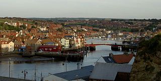
The River Esk is a river in North Yorkshire, England that empties into the North Sea at Whitby after a course of around 28 miles (45 km) through its valley of Eskdale. The river's name is derived from the Brythonic word "isca" meaning "water". The Esk is the only major river in Yorkshire that flows directly into the North Sea; all other watercourses defined as being major rivers by the Environment Agency, either flow to the North Sea via the River Tees or the Humber Estuary.

Pickering is a market town and civil parish in North Yorkshire, England, on the border of the North York Moors National Park. Historically part of the North Riding of Yorkshire, it is at the foot of the moors, overlooking the Vale of Pickering to the south.

Malton is a market town, civil parish and electoral ward in North Yorkshire, England. Historically part of the North Riding of Yorkshire, the town has a population measured for both the civil parish and the electoral ward at the 2011 Census as 4,888.

The A64 is a major road in North and West Yorkshire, England, which links Leeds, York and Scarborough. The A64 starts as the A64(M) ring road motorway in Leeds, then towards York it becomes a high-quality dual carriageway until it is east of the city, where it becomes a single carriageway for most of its route to Scarborough.

Norton-on-Derwent, commonly referred to as simply Norton, is a town and civil parish in North Yorkshire, England. Norton borders the market town of Malton, and is separated from it by the River Derwent. The 2001 Census gave the population of the parish as 6,943, increasing at the 2011 Census to 7,387.

The A171 is a road in England that links the North Yorkshire towns of Middlesbrough, Guisborough, Whitby, Robin Hood's Bay and Scarborough. Locally it is known as The Moor Road. The road is mostly single carriageway but has some sections of dual carriageway. The distance between the two towns is 47 miles (75 km)
Goathland is a village and civil parish in the Scarborough district of North Yorkshire, England. Historically part of the North Riding of Yorkshire, it is in the North York Moors national park due north of Pickering, off the A169 to Whitby. It has a station on the steam-operated North Yorkshire Moors Railway line.

Sleights is a railway station on the Esk Valley Line, which runs between Middlesbrough and Whitby via Nunthorpe. The station, situated 2 miles 78 chains (4.8 km) south-west of Whitby, serves the villages of Briggswath and Sleights, Scarborough in North Yorkshire, England. It is owned by Network Rail and managed by Northern Trains.

Pickering railway station is the southern terminus of the North Yorkshire Moors Railway and serves the town of Pickering in North Yorkshire, England. The first railway arrived in Pickering from the north in 1836, however, it wasn't until the railway was connected from the south in 1845, that the current station was built. The station was closed by British Railways in March 1965, but since 1975, the station has served as the southern terminus of the North York Moors Railway.

Newton Dale Halt railway station is a request stop on the North Yorkshire Moors Railway and serves as a stopping off point for walkers around Newton Dale and Cropton Forest in the North York Moors National Park, North Yorkshire, England. When the station was opened, the station signs were written as Newtondale Halt.

Sleights is a village in North Yorkshire, England. Located in the Esk Valley in the postal region of Whitby, the village is part of the civil parish of Eskdaleside cum Ugglebarnby and the borough of Scarborough. Sleights lies along the steep main A169 road that runs north to south between Whitby and Malton via Pickering across the North York Moors.
The A170 is an A road in North Yorkshire, England that links Thirsk with Scarborough through Hambleton, Helmsley, Kirkbysmoorside, Pickering. The road is 47 miles (76 km); a single carriageway for almost its totality.

Lockwood is a civil parish in the unitary authority of Redcar and Cleveland with ceremonial association with North Yorkshire, England. The population of Lockwood ward in the Redcar and Cleveland Unitary authority taken at the 2011 census was 2,022.

Eskdale is a valley running west to east from Westerdale on the North York Moors to Whitby on the Yorkshire Coast of England. Formed during the last major ice age, it has a classic U-shaped valley formation caused by the action of glaciers carving away the rock. Eskdale is named after its river which in Celtic means water or stream. The dale carries the River Esk from the "Esklets" above Westerdale to the sea at Whitby. The tops of its steep-sided valleys are noted for their heather moorland, whilst below the land is mainly split between pasture for cows and Swaledale sheep and arable crops such as oilseed rape.
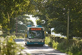
Moorsbus is a network of bus services operating to and around the North York Moors National Park and surrounding areas. It was operated from the 1980s by the North York Moors National Park Authority, and linked places such as Malton, Teesside, Thirsk, York and Hull to the National Park.

Newton Dale is a narrow dale within the North York Moors National Park in North Yorkshire, England. It was created by meltwater from a glacier carving the narrow valley. Water still flows through the dale and is known as Pickering Beck.

Lilla Cross is a marker on Lilla's Howe, Fylingdales Moor, in North Yorkshire, England. A story relates how King Edwin of Northumbria placed the cross there to mark the grave of Lilla, one of his thegns who saved his life during an assassination attempt. Whilst the current cross is believed to date to the 10th century, the original was placed there in 626. Even so, Lilla Cross is known for being the oldest marker of its type on the North York Moors. The ancient cross marks the intersection of pathways across the moor, the edges of four parishes and is also a waymarker on the Lyke Wake Walk.

Marishes is a civil parish in North Yorkshire, England. The parish has an area of some 2,960 acres, and is located between Malton and Pickering in the low-lying Vale of Pickering. Whilst the main occupation of the residents in the parish is agricultural in nature, the area is known for its onshore gas field. In 2015, the population of the parish was estimated to be 140.

