A165 road

Last updated

UK road A165.svg
A165
A165 road map.png
Route information
Length50.1 mi (80.6 km)
Major junctions
North end Burniston
54°19′17″N0°26′37″W / 54.3214°N 0.4435°W / 54.3214; -0.4435 (A165 road (northern end))
Major intersectionsUK road A171.svg A171
UK road A64.svg A64
UK road A1039.svg A1039
UK road A614.svg A614
UK road A1038.svg A1038
UK road A1035.svg A1035
UK road A1033.svg A1033
UK road A1165.svg A1165
UK road A1079.svg A1079
South end Kingston upon Hull
53°44′55″N0°20′48″W / 53.7485°N 0.3467°W / 53.7485; -0.3467 (A165 road Freetown Way(southern end))
53°44′45″N0°19′34″W / 53.7458°N 0.3262°W / 53.7458; -0.3262 (A165 road Clarence St(southern end))
Location
Country United Kingdom
Primary
destinations
Bridlington
Road network

The A165 is a road that links Scarborough and Kingston upon Hull, both in Yorkshire, England. The road is designated as a Primary Route from its junction with the A64 in Scarborough to its southern terminus in Hull.

Contents

History

New A165 by-pass, Osgodby. New A165 by-pass, Osgodby. - geograph.org.uk - 1544541.jpg
New A165 by-pass, Osgodby.

The route follows partly that of two of the Turnpikes in the area in the 18th century. In 1767, the Bridlington to White Cross Turnpike was established by Act of Parliament and the modern road follows this old route from Bridlington as far as the junction of current A165 and A1035. The modern road also follows part of the Hull-Preston-Hedon Turnpike that was established in 1745, from the point where it is known as Holderness Road in Hull to the river. Where North Bridge now stands there used to be a ferry to link the Holderness Road to the Hessle and Beverley roads as far back as 1305. [1] [2]

Road developments

In 1999, Scarborough Borough Council made plans to improve several sections of the A165. These included diverting the route of the road away from Filey Road along a new route starting at the entrance to Scarborough Golf Club to a new roundabout outside the village of Lebberston. This work was completed in December 2008. [3] The new route included a new roundabout at Osgodby and at the Cayton Bay Holiday Camp. Also included was a separate piece of work to improve the roundabout at Reighton. [4]

Route

The details in this section are taken from Ordnance Survey Open Viewer and Hull City Council. [5] [6]

Roundabout coming out of Filey Roundabout at the A165-A1039 Junction - geograph.org.uk - 301493.jpg
Roundabout coming out of Filey
A165 running over North Bridge in Kingston upon Hull A165 Bridge - geograph.org.uk - 138672.jpg
A165 running over North Bridge in Kingston upon Hull

From the northern terminus of the road, at the junction with the A171 in Burniston, the route goes through the northern suburbs of Scarborough, and past Peasholme Park before heading to the town centre. The road forms the eastern terminus of the A64 near to Scarborough Rail Station. The road exits Scarborough along a new route, parallel to the old Filey Road route, past the villages of Osgodby, Cayton Bay, Lebberston and Gristhorpe before becoming the Filey bypass. The old route used to go into the town centre and rejoin the current route at the junction with the A1039 road. The A1039 now merges with the A165 for a short distance. The road continues through open countryside until it reaches the outskirts of Bridlington.

The route diverts away from the original road that went into the town centre, now the A1038, and instead goes around the western side to the junction with the A164 near Bridlington Hospital. It turns towards the town centre here until it reaches the junction with the old route at Kingsgate. The road then exits the town in a south-west direction. The road goes through open countryside again, passing the villages of Fraisthorpe, Barmston, Lissett, Beeford, Brandesburton and Leven. At Leven, the road merges with the A1035 forming the bypass to the village of Leven. At the roundabout with Beverley Road, the two roads separate and the A165 continues southward through Long Riston. It then passes through Skirlaugh, Coniston and Ganstead before reaching the outskirts of Hull.

Within the city limits the A165 is first known as Holderness Road which it follows all the way into the centre crossing the A1033 (Mount Pleasant). According to the Road Classifying Authority for Hull City Council, at the junction of Witham and Clarence Street, the road splits. One section continues on Witham crossing the A1165 (New Cleveland Street/Great Union Street) and the River Hull over the Grade II listed [7] North Bridge in George Street (a Scherzer rolling lift bridge). It then becomes Freetown Way before terminating at the A1079 (Beverley Road/Ferensway) junction. The other section continues down Clarence Street to terminate at the junction with the A1165 on Great Union Street. [8]

Speed limits

Much of the road is through countryside, and has the National speed limit (60 miles per hour (97 km/h)) applied. A 3.5 miles (5.6 km) stretch of the road passing the village of Leven in East Yorkshire (known as the Leven bypass) is dual carriageway, carrying a 70 miles per hour (110 km/h) speed limit. The road does pass through many villages and settlements, where the limit is reduced. A 30 miles per hour (48 km/h) speed limit is in operation through Beeford, Bridlington, Filey, Skirlaugh. A 40 miles per hour (64 km/h) limit exists through other villages such as Fraisthorpe and Coniston. In Scarborough, Bridlington, and the Kingston upon Hull boundary, the limit is 30 miles per hour (48 km/h) or 40 miles per hour (64 km/h). Some stretches of 30 miles per hour (48 km/h) or 40 miles per hour (64 km/h) limits are monitored at certain times by mobile speed cameras, operated by Safer Roads Humber.

Safety

In the European Road Assessment Programme (EuroRAP) survey, which gives all major roads in Europe a safety rating, the A165 is categorised as 'Medium-high risk'. [9]

Related Research Articles

<span class="mw-page-title-main">A63 road</span> Road in Yorkshire, England

The A63 is a major road in Yorkshire, England between Leeds and Kingston upon Hull. A section between North Cave and Hull forms the eastward continuation of the M62 motorway and is part of the unsigned Euroroute E20.

<span class="mw-page-title-main">A614 road</span> Road in England

The A614 is a main road in England running through the counties of Nottinghamshire, South Yorkshire and the East Riding of Yorkshire.

<span class="mw-page-title-main">A64 road</span> Road in West and North Yorkshire, England

The A64 is a major road in North and West Yorkshire, England, which links Leeds, York and Scarborough. The A64 starts as the A64(M) ring road motorway in Leeds, then towards York it becomes a high-quality dual carriageway until it is east of the city, where it becomes a single carriageway for most of its route to Scarborough.

<span class="mw-page-title-main">Hunmanby</span> Village and civil parish in North Yorkshire, England

Hunmanby is a large village and civil parish in North Yorkshire, England. It was part of the East Riding of Yorkshire until 1974. From 1974 to 2023 it was in the Scarborough district of the shire county of North Yorkshire. In 2023 the district was abolished and North Yorkshire became a unitary authority. It is on the edge of the Yorkshire Wolds, 3 miles (4.8 km) south-west of Filey, 9 miles (14 km) south of Scarborough and 9 miles (14 km) north of Bridlington. The village is on the Centenary Way.

<span class="mw-page-title-main">Royal Oak, North Yorkshire</span> Area in North Yorkshire, England

Royal Oak is an area in North Yorkshire, England, between Scarborough and Bridlington, next to Filey and Hunmanby. The place itself is marked by a public house, also named The Royal Oak and a railway crossing on the Yorkshire Coast Line listed as being 43 miles 4 chains (69.3 km) north of Hull Paragon station. Two railway junctions that formed a spur to the railway station at Filey Holiday Camp were also located just to the south of the A165 crossing. These were known as the Royal Oak Junctions.

<span class="mw-page-title-main">Hull Paragon Interchange</span> Transport interchange in Kingston upon Hull, East Riding of Yorkshire, England

Hull Paragon Interchange is a transport interchange providing rail, bus and coach services located in the city centre of Kingston upon Hull, England. The G. T. Andrews-designed station was originally named Paragon Station, and together with the adjoining Station Hotel, it opened in 1847 as the new Hull terminus for the growing traffic of the York and North Midland (Y&NMR) leased to the Hull and Selby Railway (H&S). As well as trains to the west, the station was the terminus of the Y&NMR and H&S railway's Hull to Scarborough Line. From the 1860s the station also became the terminus of the Hull and Holderness and Hull and Hornsea railways.

<span class="mw-page-title-main">Seamer railway station</span> Railway station in North Yorkshire, England

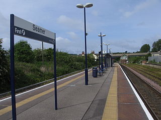
Seamer railway station serves the village of Seamer in North Yorkshire, England. It lies near the end of the Scarborough branch on the TransPennine Express North TransPennine route, 39 miles (63 km) east of York at its junction with the northern end of the Yorkshire Coast Line. Seamer station is managed by TransPennine Express, with services being run by both Northern Trains and TransPennine Express.

<span class="mw-page-title-main">Hull–Scarborough line</span> Railway line in Yorkshire, England

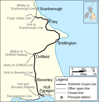
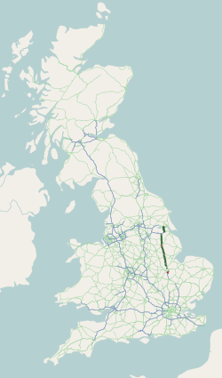
The Hull–Scarborough line, also known as the Yorkshire Coast Line, is a railway line in Yorkshire, England that is used primarily for passenger traffic. It runs northwards from Hull Paragon via Beverley and Driffield to Bridlington, joining the York–Scarborough line at a junction near Seamer before terminating at Scarborough railway station.

<span class="mw-page-title-main">Beeford</span> Village and civil parish in the East Riding of Yorkshire, England

Beeford is a village and civil parish in the East Riding of Yorkshire, England. It is situated at the junction of the A165 and the B1249, and approximately 10 miles (16 km) north-east from Beverley and 8 miles (13 km) south from Bridlington.

<span class="mw-page-title-main">Cayton</span> Village and civil parish in North Yorkshire, England

Cayton is a village and civil parish in the Scarborough borough of North Yorkshire, England, 4 miles (6 km) south of Scarborough.

<span class="mw-page-title-main">Bridlington railway station</span> Railway station in the East Riding of Yorkshire, England

Bridlington railway station serves the seaside town of Bridlington in the East Riding of Yorkshire, England. It is located on the Yorkshire Coast Line and is operated by Northern who provide all passenger train services.

<span class="mw-page-title-main">New York State Route 376</span> State highway in Dutchess County, New York, US

New York State Route 376 (NY 376) is a state highway located entirely within Dutchess County in the Hudson Valley region of New York in the United States. The route begins at an intersection with NY 52 in East Fishkill and passes north through Hopewell Junction and Red Oaks Mill on its way to the city of Poughkeepsie. It ends at a junction with U.S. Route 44 (US 44) and NY 55 east of the city limits in Arlington, a hamlet in the town of Poughkeepsie. NY 376 was originally designated as part of NY 39 in the mid-1920s. In the 1930 renumbering of state highways in New York, the East Fishkill–Poughkeepsie portion of NY 39 was renumbered to New York State Route 202. NY 202 was renumbered to NY 376 in 1935 to avoid numerical duplication with the new US 202.

<span class="mw-page-title-main">A1079 road</span> Road in Northern England

The A1079 is a major road in Northern England. It links the cities of York and Kingston upon Hull, both in Yorkshire. The road is noted for its past safety issues, and regularly features in the Road Safety Foundations reports on Britain's most dangerous roads. Campaigners have been calling for the entire route to be made into a dual carriageway.

<span class="mw-page-title-main">National Cycle Route 1</span> Cycle route in the United Kingdom

National Cycle Route 1 is a route of the National Cycle Network, running from Dover to Tain. The 1,264 mi-long (2,034-kilometre) cycle-path is located in the United Kingdom.

<span class="mw-page-title-main">York–Beverley line</span> Former English railway line

The York–Beverley line was a railway line between York, Market Weighton and Beverley in Yorkshire, England. The line was sanctioned in 1846 and the first part, the York to Market Weighton Line opened in 1847. Construction of the second part to Beverley was delayed for 17 years in part by the downfall of George Hudson, and a less favourable financial environment following the collapse of the 1840s railway bubble; the North Eastern Railway revived and completed the scheme in the 1860s; the Market Weighton to Beverley Line opened in 1865.

<span class="mw-page-title-main">Muston, North Yorkshire</span> Village and civil parish in North Yorkshire, England

Muston is a village and civil parish, in North Yorkshire, England. It was historically in the East Riding of Yorkshire. The village is situated 1.5 miles (2.4 km) south-west from the centre of the coastal town of Filey, and on the A1039 road.

Staxton is a village in North Yorkshire, England, part of the civil parish of Willerby, and situated approximately 8.2 miles from Scarborough town centre.

<span class="mw-page-title-main">A1033 road</span> A road in the East Riding of Yorkshire, England

The A1033 road is a main arterial route across Kingston upon Hull and the East Riding of Yorkshire connecting Hull with Withernsea. The road carries traffic to and from the Port of Hull and Salt End at its western end, and local and holiday traffic at its eastern end. It is a primary route from the junction of the A63 road to the Salt End roundabout and is maintained on that section by National Highways. The section by the docks is also part of a designated abnormal load route.

The Minster Way is a 50-mile (80 km) walking route between the Minsters of Beverley and York in England. It crosses the chalk hills of the Yorkshire Wolds, as well as a wide variety of the East Riding of Yorkshire countryside. Part of the route follows the Yorkshire Wolds Way National Trail across Sylvan Dale before diverting to Millington, Bishop Wilton and Stamford Bridge, where it follows the River Derwent into the Plain of York as far as the River Ouse.

<span class="mw-page-title-main">EastRider</span> Network of long-distance bus routes in East and North Yorkshire, England

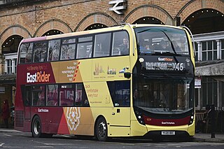
EastRider is the brand name given to a network of long-distance bus services across the East Riding of Yorkshire and North Yorkshire, operated by Go-Ahead Group company East Yorkshire. The EastRider services, all operating from Kingston upon Hull, serve the destinations of Bridlington, Goole, Hornsea, Withernsea and York using a fleet of specially-branded high-specification buses.

References

  1. "East Riding of Yorkshire Turnpikes" . Retrieved 29 December 2015.
  2. "A History of the County of York East Riding: Volume 1, the City of Kingston Upon Hull". pp. 387–397. Retrieved 29 December 2015.
  3. "A165 Lebberston Diversion" . Retrieved 29 December 2015.
  4. Bourn, John, ed. (2007). Estimating and monitoring the costs of building roads in England. London: The National Audit Office. p. 7. ISBN   978-0-10-294460-0.
  5. Ordnance Survey Open Viewer
  6. Hull City Council
  7. Historic England. "New North Bridge, George Street (1292933)". National Heritage List for England . Retrieved 26 April 2013.
  8. "Hull City Council - Classified Roads" . Retrieved 29 December 2015.
  9. "䕵牯剁倠㨺⁒潡搠䱯潫異›㨠卥慲捨⁒敳畬瑳‭⁇䈠䄱㘵
剩獫⁒慴攩". www.eurorap.org. Archived from the original on 26 July 2011. Retrieved 13 January 2022.
Map all coordinates using: OpenStreetMap

54°02′07″N0°14′36″W / 54.0352°N 0.2432°W / 54.0352; -0.2432 (A165 road)