
Lowestoft is a coastal town and civil parish in the East Suffolk district of Suffolk, England. As the most easterly UK settlement, it is 110 miles (177 km) north-east of London, 38 miles (61 km) north-east of Ipswich and 22 miles (35 km) south-east of Norwich, and the main town in its district. The estimated population in the built-up area exceeds 70,000. Its development grew with the fishing industry and as a seaside resort with wide sandy beaches. As fishing declined, oil and gas exploitation in the North Sea in the 1960s took over. While these too have declined, Lowestoft is becoming a regional centre of the renewable energy industry.

The A12 is a major road in Eastern England. It runs north-east/south-west between London and the coastal town of Lowestoft in the north-eastern corner of Suffolk, following a similar route to the Great Eastern Main Line until Ipswich. A section of the road between Lowestoft and Great Yarmouth became part of the A47 in 2017. Between the junctions with the M25 and the A14, the A12 forms part of the unsigned Euroroute E30. Unlike most A roads, this section of the A12, together with the A14 and the A55, has junction numbers as if it were a motorway.
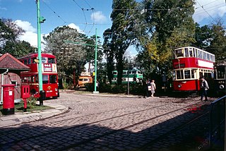
The East Anglia Transport Museum is an open-air transport museum, with numerous historic public transport vehicles. It is located in Carlton Colville a suburb of Lowestoft, Suffolk. It is the only museum in the country where visitors can ride on buses, trams and trolleybuses, as well as a narrow-gauge railway.

The East Suffolk line is an un-electrified 49-mile secondary railway line running between Ipswich and Lowestoft in Suffolk, England. The traffic along the route consists of passenger services operated by Greater Anglia, while nuclear flask trains for the Sizewell nuclear power stations are operated by Direct Rail Services.
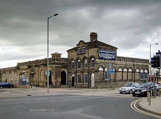
Lowestoft railway station serves the town of Lowestoft, Suffolk. It is the eastern terminus of the East Suffolk Line from Ipswich and is one of two eastern termini of the Wherry Lines from Norwich. Lowestoft is 23 miles 41 chains (37.8 km) down the line from Norwich and 48 miles 75 chains (78.8 km) measured from Ipswich; it is the easternmost station on the National Rail network in the United Kingdom.

Carlton Colville is a civil parish and suburb of Lowestoft in the English county of Suffolk. It is 3 miles (5 km) south-west of the centre of the town, in the East Suffolk district. The area lies along the A146 Lowestoft to Beccles road.

Kirkley & Pakefield Football Club is a football club based in Lowestoft, Suffolk, England. They are currently members of the Eastern Counties League Premier Division and play at Walmer Road.

First Eastern Counties is a bus operator providing services in Norfolk and Suffolk in eastern England. It is a subsidiary of FirstGroup and has five depots in operating areas spread out across East Anglia. These areas are Norwich, Ipswich, Great Yarmouth, Lowestoft and King's Lynn.
Ormiston Denes Academy is a secondary school with academy status located in the northern outskirts of Lowestoft in the English county of Suffolk. It has around 1000 students aged 11 to 16.

Kirkley is an area of the town of Lowestoft in the East Suffolk district of the English county of Suffolk. It is located south of the centre of Lowestoft and the town's harbour and Lake Lothing. Kirkley was originally an independent village but is now part of the urban conurbation of Lowestoft. In 2011 the ward had a population of 7439.

The A146 is an A road that connects Norwich in Norfolk and Lowestoft in Suffolk, two of East Anglia's largest population centres. It is around 27 miles (43 km) in length and has primary classification along its entire route. It is mainly single carriageway throughout its route, with the exception of a section of dual carriageway on the southern edge of Norwich.
The NR postcode area, also known as the Norwich postcode area, is a group of 35 postcode districts in the east of England, within 16 post towns. These cover central and eastern Norfolk and part of north-east Suffolk.

Lowestoft North railway station was in Lowestoft, Suffolk, England. It closed in 1970.

Suffolk Fire and Rescue Service (SFRS) is the statutory fire and rescue service covering the county of Suffolk in East Anglia, England. It was formed in 1948 as the Suffolk & Ipswich Fire Service, before changing after the 1974 Local Government Review to 'Suffolk Fire Service'. Following the 2004 Fire & Rescue Services Act, the service name was changed to Suffolk Fire & Rescue Service to better reflect its role. Suffolk has a population of 760,556 and covers 1,466 square miles (3,800 km2). The county town is Ipswich with other major towns including Lowestoft, Bury St-Edmunds, Felixstowe and Newmarket.
Gunton is a suburb of Lowestoft, in the East Suffolk district, in the English county of Suffolk. Gunton was a small coastal village, but over the years it has been suburbanised. Gunton has an estimated population of 6,640. The main A12 or Yarmouth Road runs through the area. The eastern part of Gunton, from Yarmouth Road to Gunton Cliff, is one of the most affluent parts of Lowestoft, after the North Broads area of Oulton Broad.
Lowestoft Corporation Tramways was the operator of the electric tramway system that served Lowestoft from 22 July 1903 until 8 May 1931.
