A18 road (England)

Last updated

UK road A18.svg
A18
A18 road map.png
Route information
Length58.2 mi [1]  (93.7 km)
Major junctions
FromUK road A630.svg A630 in Doncaster
53°30′53″N1°08′19″W / 53.5147°N 1.1386°W / 53.5147; -1.1386 (A18 road (western end))
Major intersectionsUK road A638.svg A638 in Doncaster

UK-Motorway-M180.svg M180 in Hatfield
UK-Motorway-A1077 (M).svgUK road A1077.svg A1077(M)  / A1077 in Gunness
UK road A159.svg A159 in Scunthorpe
UK-Motorway-M180.svgUK road A15.svg M180  / A15 in Broughton
UK road A1173.svg A1173 in Riby

Contents

UK road A46.svg A46 in Laceby
ToUK road A16.svg A16 near Ludborough
53°26′02″N0°02′28″W / 53.4338°N 0.0412°W / 53.4338; -0.0412 (A18 road (western end))
Location
Country United Kingdom
Constituent country England
Counties South Yorkshire, Lincolnshire
Primary
destinations
Scunthorpe
Road network
UK road A17.svg A17 UK road A19.svg A19

The A18 is a road in England that links Doncaster in South Yorkshire with Ludborough in Lincolnshire, via Scunthorpe and Grimsby. Much of its route has been superseded by the M180 motorway.

Route

Doncaster – M180

The A18 begins as a dual-carriageway and trunk road at the Balby Flyover junction with the A630 in Balby in Doncaster, under which runs the East Coast Main Line. It meets the A638 (former Great North Road) at the Sidings Roundabout then becomes Carr House Road, overlapping the A638. At the Racecourse Roundabout in Belle Vue, the A638 exits to the right (former Great North Road), and the road becomes Leger Way. Near Intake, it becomes a single carriageway and continues to Scunthorpe. At the Sandall Park Roundabout the road meets its old route and becomes Thorne Road. At the Shaw Lane Roundabout it meets the A630 and runs under a railway line. At the next roundabout, on the edge of Doncaster, the A630 leaves to the right, as a trunk road to the M18. The road, now without trunk (primary) status, passes through Edenthorpe.

The road enters Dunsville as High Street and becomes Doncaster Road. In Hatfield, it becomes Manor Road and then High Street, and crosses the M18. It becomes Epworth Road and meets the A1146 near Hatfield Woodhouse, then meets the A614 from the right from Finningley. The road becomes Tudworth Road and overlaps the A614; at the Tudworth Roundabout, the A18 continues to the right of the M180

M180 – Brigg

As High Levels Bank, it crosses a flat landscape known as Hatfield Chase and enters North Lincolnshire. It runs alongside the large North Engine Drain next to the M180. At Crowle, it meets the A161, close to junction 2 of the M180 and crosses Pilfrey Bridge over the Three Rivers. The A18 meets the B1392 (for Keadby) and passes through Gunness, crossing the B1216 (for Burringham) as Station Road. It meets the A1077 Scunthorpe ring road and the M181 at the Frodingham Grange Roundabout.

The road enters the Queensway Roundabout for the trunk road A159 at Old Brumby, becoming the non-trunk dual-carriageway Queensway. It passes through New Brumby, and at the Ashby Ville Roundabout it meets the A1029. The road meets the Briggate Lodge Roundabout on the line of Ermine Street, for junction 4 for the M180 and the trunk-road A15.

Brigg – Ludborough

At Scawby Brook, there is a roundabout with the B1206 (for Scawby), and the road enters Brigg to the left as Scawby Road, becoming Bridge Street and then Ancholme Way. The B1206 (former A15) leaves to the left and the road enters Wrawby as Brigg Road and becomes Melton Road.

The road passes through Melton Ross and passes next to Humberside Airport. At the B1210 (for Brocklesby) junction, the road heads to the right, entering Lincolnshire and the district of West Lindsey, and passes through Great Limber as High Street. It meets the B1211 and heads to the right as Barton Street (a Roman road). Near Riby, the road becomes a trunk road (until its terminus) then a dual-carriageway close to where it enters North East Lincolnshire.

The road meets the A46 Grimsby road, and heads straight on over the roundabout. The A18 used to continue eastwards from here along the present A46 into Grimsby, and now continues southwards over Welbeck Hill along the former B1431. The boundary of Lincolnshire and North East Lincolnshire runs down the middle of the road for about 3 miles (4.8 km). The road re-enters Lincolnshire and the district of East Lindsey. The road follows the former A16 from Ludborough to near Utterby, where is meets the A16 (for Louth).

The last section, between the junction with the A46 at Laceby and the junction with the A16 at Ludborough, was designated by the Road Safety Foundation as the most dangerous in the country for car drivers, drawing on collated data on the number of fatal and serious-injury collisions in 2010. [2] During a 2015 inquest, a coroner called for an independent review of the A18 near Grimsby; the coroner was reacting to the death of a family after a collision with a lorry. [3] In 2016, the government announced that £175 million would be made available for safety improvements on roads like the A18. [4]

A18(M) motorway

UK-Motorway-A18 (M).svg

A18(M)

Location Hatfield, South Yorkshire
Length1.0 mi (1.6 km)
Existed1972–1978

The A18(M) was a short motorway about 1 mile (1.6 km) long that connected the M18, from what is now junction 5 north of Hatfield, South Yorkshire, to the A18. The A18(M) was built in 1972 but was redesignated after the M180 was built in 1978.

The western end of the M180 from M18 junction 5 to the junction 1 eastbound slip road was previously part of the A18(M). The eastbound slip road to the roundabout was the eastbound carriageway A18(M). About 0.5 miles (0.8 km) of the westbound A18(M) carriageway was abandoned when the M180 was built on a new alignment.

Junction list

CountyLocationmi [1] kmDestinationsNotes
South Yorkshire Doncaster 0.00.0UK road A630.svgUK-Motorway-A1 (M).svg A630 to A1(M)  Rotherham, The North Western terminus
0.40.64UK road A638.svgUK road A6182.svgUK-Motorway-A1 (M).svgUK-Motorway-M18.svgUK-Motorway-M1.svgUK-Motorway-M180.svgUK road A1.svgUK road A19.svg A638 north / A6182 south to A1(M)  / M18  / M1  / M180  / A1  / A19  The North, The South, Sheffield, Scunthorpe, Selby To A1 and The North signed eastbound only; western terminus of A638 concurrency; northern terminus of A6182
1.42.3UK road A638.svgAircraft Airport ecomo.svg A638 east / Bennetthorpe (Bawtry Road) Bawtry, Doncaster town centre, Rossington, Cantley, Robin Hood Airport Robin Hood Airport signed westbound only; eastern terminus of A638 concurrency
3.96.3UK road A630.svgUK road A1.svgUK road A638.svg A630 west (Wheatley Hall Road) to Ogden Road / A1  / A638  Wakefield, The North, Doncaster town centreDoncaster town centre signed westbound only; western terminus of A630 concurrency
EdenthorpeArmthorpe boundary4.16.6UK road A630.svgUK-Motorway-M18.svgUK-Motorway-M180.svgUK-Motorway-M62.svg A630  / M18  / M180  / M62  Scunthorpe To M180 and M62 signed eastbound only; eastern terminus of A630 concurrency
Hatfield 8.814.2UK road A1146.svg A1146 north (Thorne Road)Southern terminus of A1146
9.515.3UK road A614.svgAircraft Airport ecomo.svg A614 south (Stone Hill) Bawtry, Robin Hood Airport Western terminus of A614 concurrency
10.316.6UK-Motorway-M180.svgUK-Motorway-M18.svgUK-Motorway-M62.svg M180 west to M18  / M62  Scunthorpe, Leeds, Hull
HatfieldThorne boundary10.617.1UK road A614.svg A614 north (Tudworth Road) Thorne Eastern terminus of A614 concurrency
Lincolnshire Crowle and Ealand 16.827.0UK road A161.svgUK-Motorway-M180.svg A161 to M180  Goole, Gainsborough
KeadbyGunness boundary20.8–
20.9
33.5–
33.6
Keadby Bridge over River Trent
Gunness 22.536.2UK-Motorway-A1077 (M).svgUK road A1077.svgUK-Motorway-M181.svgUK-Motorway-M180.svg A1077(M) south / A1077 north-east to M181  / M180  / B1216 Winterton, Hull, Grimsby, Doncaster, Flixborough To B1216 and destinations signed eastbound only
Scunthorpe 24.739.8UK road A159.svg A159 south / Ashby Road Town centre, Messingham, Gainsborough, Ashby, Bottesford Northern terminus of A159
26.642.8UK road A1029.svgUK road A1077.svg A1029 north / Lakeside Parkway to A1077  / B1430 Town centre, Winterton, Burton upon Stather, Flixborough Southern terminus of A1029
Broughton 29.347.2UK road A15.svgUK-Motorway-M180.svgUK road A180.svg A15  / M180  / A180  Lincoln, Grimsby, Doncaster
Brigg 32.752.6UK road A1084.svg A1084 south-east to Bigby Road / B1434 Caistor, Market Rasen, Bigby, Howsham North-western terminus of A1084
Melton RossBarnetby le Wold boundary36.658.9UK-Motorway-M180.svgUK road A15.svgUK road A180.svg M180  / A15 to Kings Road / A180  Scunthorpe, Lincoln, Hull, Humber Bridge, Barnetby le Wold, Grimsby, Immingham
Riby 46.174.2UK road A1173.svgUK road A46.svg A1173 (Riby Road) to A46  Caistor, Immingham, Lincoln, Riby, Stallingborough, Healing Brief concurrency
Laceby 48.277.6UK road A46.svg A46 (Grimsby Road) Lincoln, Grimsby, Market Rasen, Caistor, Cleethorpes, Laceby
LudboroughUtterby boundary58.293.7UK road A16.svgUK road A1028.svg A16 (Main Road) to A1028  Grimsby, Boston, Skegness, North Thoresby, Holton-le-Clay, Utterby, Louth, Mablethorpe Eastern terminus
1.000 mi = 1.609 km; 1.000 km = 0.621 mi

Related Research Articles

<span class="mw-page-title-main">North East Lincolnshire</span> Borough in England

North East Lincolnshire is a unitary authority area with borough status in Lincolnshire, England. It borders the borough of North Lincolnshire and districts of West Lindsey and East Lindsey. The population of the district in the 2011 Census was 159,616. The administrative centre and largest settlement is Grimsby and the borough includes the towns of Cleethorpes and Immingham as well as the villages of New Waltham, Waltham, Humberston, Healing and Great Coates. The borough is also home to the Port of Grimsby and Port of Immingham as well as Cleethorpes beach.

<span class="mw-page-title-main">Brigg</span> Market town in North Lincolnshire, England

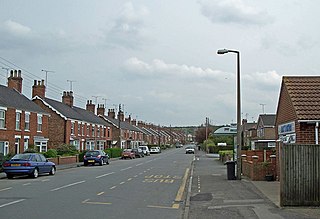
Brigg (/'brɪg/) is a market town in North Lincolnshire, England, with a population of 5,076 in the 2001 UK census, the population increased to 5,626 at the 2011 census. The town lies at the junction of the River Ancholme and east–west transport routes across northern Lincolnshire. As a formerly important local centre, the town's full name of Glanford Brigg is reflected in the surrounding area and local government district of the same name. The town's urban area includes the neighbouring hamlet of Scawby Brook.

<span class="mw-page-title-main">A57 road</span> Road in England

The A57 is a major road in England. It runs east from Liverpool to Lincoln via Warrington, Salford and Manchester, and then through the Pennines over the Snake Pass (between the high moorlands of Bleaklow and Kinder Scout), around the Ladybower Reservoir, through Sheffield and past Worksop. Between Liverpool and Glossop, the road has largely been superseded by the M62, M602 and M67 motorways. Within Manchester a short stretch becomes the Mancunian Way, designated A57(M).

<span class="mw-page-title-main">M18 motorway (Great Britain)</span> Motorway in England

The M18 is a motorway in Yorkshire, England. It runs from the east of Rotherham to Goole and is approximately 26 miles (42 km) long. A section of the road forms part of the unsigned Euroroute E13.
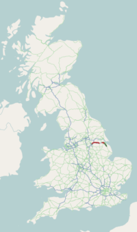
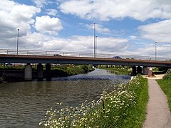
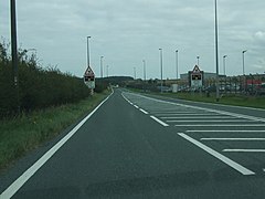
<span class="mw-page-title-main">M180 motorway</span> Motorway in England

The M180 is a 25.5-mile (41 km) motorway in eastern England, starting at junction 5 on the M18 motorway in Hatfield, within the Metropolitan Borough of Doncaster, South Yorkshire, and terminating at Barnetby, Lincolnshire, some 10 miles (16 km) from the port of Immingham and 14 miles (23 km) from the port of Grimsby. The A180 road continues to the east for Grimsby, Cleethorpes and Immingham. Scunthorpe, Lincoln, Hull, Brigg, Bawtry and the Isle of Axholme can be accessed using the motorway. Humberside Airport, the now-closed Doncaster Sheffield Airport, and the Killingholme, Humber and Lindsey oil refineries are close to the motorway. The road forms part of the unsigned Euroroute E22 and is the main route along the south bank of the Humber Estuary.

<span class="mw-page-title-main">A46 road</span> Road in England

The A46 is a major A road in England. It starts east of Bath, Somerset and ends in Cleethorpes, Lincolnshire, but it does not form a continuous route. Large portions of the old road have been lost, bypassed, or replaced by motorway development. Between Leicester and Lincoln the road follows the course of the Roman Fosse Way, but between Bath and Leicester, two cities also linked by the Fosse Way, it follows a more westerly course.

<span class="mw-page-title-main">West Lindsey</span> District in England

West Lindsey is a local government district in Lincolnshire, England. Its council is based in Gainsborough, the district's largest town. The district also includes the towns of Caistor and Market Rasen, along with numerous villages and surrounding rural areas. The east of the district includes part of the Lincolnshire Wolds, a designated Area of Outstanding Natural Beauty.

<span class="mw-page-title-main">A15 road (England)</span> Road in England

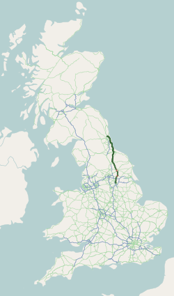
The A15 is a major road in England. It runs north from Peterborough via Market Deeping, Bourne, Sleaford and Lincoln along a variety of ancient, Roman, and Turnpike alignments before it is interrupted at its junction with the M180 near Scawby. The road restarts 10 miles (16 km) east, and then continues north past Barton-upon-Humber, crossing the Humber on the Humber Bridge before terminating at Hessle near Kingston upon Hull.

<span class="mw-page-title-main">A52 road</span> Major road in the East Midlands of England

The A52 is a major road in the East Midlands, England. It runs east from a junction with the A53 at Newcastle-under-Lyme near Stoke-on-Trent via Ashbourne, Derby, Stapleford, Nottingham, West Bridgford, Bingham, Grantham, Boston and Skegness to the east Lincolnshire coast at Mablethorpe. It is approximately 147 miles (237 km) long.

<span class="mw-page-title-main">Hatfield, South Yorkshire</span> Town and civil parish in South Yorkshire, England

Hatfield is a town and civil parish in the City of Doncaster in South Yorkshire, England. It had a population of 17,236 at the 2011 Census. The town is located on the A18 road between Doncaster and Scunthorpe, and to the west of the M18 motorway. It shares a railway station with Stainforth on the line between Goole and Scunthorpe, and Doncaster. Recorded history in the parish extends as far back as 730, when Bede wrote about the Northumbrian King, Edwin, being killed in battle in the area.

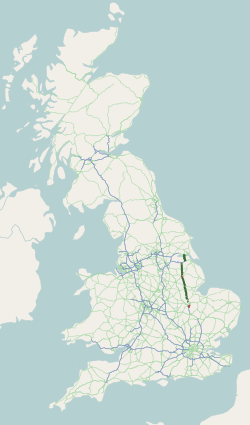
The M181 is a motorway that links the town of Scunthorpe, England, to the M180 motorway. A spur of the M180, the road is virtually straight through its entire 2-mile (3.2 km) length. It was opened in December 1978, at the same time as the section of M180 from junction 3 (A15) to the east side of the River Trent.

<span class="mw-page-title-main">A614 road</span> Road in England

The A614 is a main road in England running through the counties of Nottinghamshire, South Yorkshire and the East Riding of Yorkshire.

Lincolnshire is a large county in England with a sparse population distribution, which leads to problems funding all sorts of transport. The transport history is long and varied, with much of the road network still based on the Roman model, and the once extensive rail network a shadow of its former self.

<span class="mw-page-title-main">Barnetby le Wold</span> Small rural village and civil parish in North Lincolnshire, England

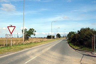
Barnetby le Wold is a village and civil parish in North Lincolnshire, Lincolnshire, England, located between Brigg and Immingham. The village is also near Barton-upon-Humber. The population of the parish in the 2001 census was 1,593. This increased by 148 to 1,741 in the 2011 census.

<span class="mw-page-title-main">A180 road (England)</span> Road in northern England

The A180 is a primary route in northern England, that runs from the M180 motorway to Cleethorpes. The road is a continuation of the M180, but built to lower specifications: it is mainly dual two-lane without hard shoulders. The road is dual carriageway for 16.87 miles (27.15 km) from the M180 to Grimsby, and is a single carriageway road for 2 miles (3.2 km) between Grimsby and Cleethorpes beach.

<span class="mw-page-title-main">A630 road</span> Road in England

The A630 is an A road in the United Kingdom. It runs between Sheffield city centre (53.3762°N 1.3998°W) and junction 4 of the M18 motorway (53.5400°N 1.0229°W), passing through Rotherham and Doncaster on the way. The road is entirely in South Yorkshire.

<span class="mw-page-title-main">A638 road</span> Road in England

The A638 is a major road in England. It runs between the A1 at Markham Moor, Nottinghamshire and Chain Bar Interchange – Junction 26 of the M62 motorway, south of Bradford in West Yorkshire.

<span class="mw-page-title-main">A631 road</span> Road in England

The A631 is a road running from Sheffield, South Yorkshire to Louth, Lincolnshire in England. It passes through the counties of South Yorkshire, Nottinghamshire and Lincolnshire. The road has many towns on its route including Rotherham, Maltby, Gainsborough and Market Rasen. It is mostly single road throughout its length but has some stretches of dual carriageway as well.

<span class="mw-page-title-main">South Humberside Main Line</span>

The South Humberside Main Line runs from Doncaster on the East Coast Main Line to Thorne where it diverges from the Sheffield to Hull Line. It then runs eastwards to Scunthorpe and the Humber ports of Immingham and Grimsby, with the coastal resort of Cleethorpes as terminus.

<span class="mw-page-title-main">Broughton and Appleby</span> Human settlement in England

Broughton and Appleby is an electoral ward in North Lincolnshire. It elects two councillors to North Lincolnshire Council using the first past the post electoral method, electing both councillors every four years. Since its creation in 2003 after boundary changes, it has continually elected Conservative councillors.

References

  1. 1 2 "Doncaster, UK to Hatfield, Doncaster, UK to 47 Glanville Ave, Scunthorpe DN17 1DB, UK to Brigg, UK to Lincoln Gate, Grimsby, UK to A16, Louth LN11 0TP, UK". Google Maps . Alphabet Inc. Retrieved 30 March 2023.
  2. Clark, Eric (1 July 2010). "Hidden dangers of Britain's deadliest roads". The Telegraph. Retrieved 17 July 2015.
  3. "Coroner calls for "killer" A18 road review". BBC News. 8 March 2016. Retrieved 29 August 2017.
  4. "£175m to tackle 50 killer roads, under £1.3bn plans - The Transport Network". www.transport-network.co.uk. Retrieved 29 August 2017.
Map all coordinates using: OpenStreetMap