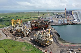
The River Tees, in Northern England, rises on the eastern slope of Cross Fell in the North Pennines and flows eastwards for 85 miles (137 km) to reach the North Sea between Hartlepool and Redcar near Middlesbrough. The modern day history of the river has been tied with the industries on Teesside in its lower reaches, where it has provided the means of import and export of goods to and from the North East England. The need for water further downstream also meant that reservoirs were built in the extreme upper reaches, such as Cow Green.

Hartlepool is a seaside and port town in County Durham, England. It is governed by a unitary authority borough named after the town. The borough is part of the devolved Tees Valley area. With an estimated population of 87,995, it is the second-largest settlement in County Durham.
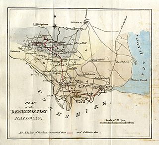
The Stockton and Darlington Railway (S&DR) was a railway company that operated in north-east England from 1825 to 1863. The world's first public railway to use steam locomotives, its first line connected collieries near Shildon with Darlington and Stockton-on-Tees in County Durham, and was officially opened on 27 September 1825. The movement of coal to ships rapidly became a lucrative business, and the line was soon extended to a new port at Middlesbrough. While coal waggons were hauled by steam locomotives from the start, passengers were carried in coaches drawn by horses until carriages hauled by steam locomotives were introduced in 1833.

Middlesbrough is a town in the Middlesbrough unitary authority borough of North Yorkshire, England. The town is in Teesdale, near the North York Moors National Park. With a population of 148,215, it was classed as large town to smaller city at the 2021 UK census. It is the largest town of the wider Teesside area, which had a population of 376,633 in 2011.
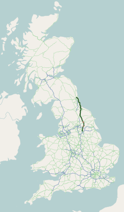
The A19 is a major road in England running approximately parallel to and east of the A1 road. Although the two roads meet at the northern end of the A19, the two roads originally met at the southern end of the A19 in Doncaster, but the old route of the A1 was changed to the A638. From Sunderland northwards, the route was formerly the A108. In the past the route was known as the East of Snaith-York-Thirsk-Stockton-on-Tees-Sunderland Trunk Road. Most traffic joins the A19, heading for Teesside, from the A168 at Dishforth Interchange.

The Tees Valley is a mayoral combined authority area in North East England, around the lower River Tees. The area is not a geographical valley; the local term for the valley is Teesdale. The area covers five council areas: Darlington, Hartlepool, Middlesbrough, Redcar and Cleveland and Stockton-on-Tees.

The Tees Transporter Bridge, also referred to as the Middlesbrough Transporter Bridge or locally as The Transporter, is a bridge over the River Tees in northern England. The northern side is in Port Clarence and the southern side is in the Middlehaven, the latter an area of Middlesbrough. It is grade II* listed and the longest existing transporter in the world. and its winch house and piers are grade II listed.

Port Clarence is a small village in the borough of Stockton-on-Tees, County Durham, England. It is on the north bank of the River Tees, and near the northern end of the Middlesbrough Transporter Bridge.

Seaton Carew is a seaside resort in the Borough of Hartlepool in County Durham, England. It had an estimated population of 6,018. The area is named after a Norman French family called Carou who owned lands in the area and settled there, while 'Seaton' means farmstead or settlement by the sea.

The Durham Coast Line is an approximately 39.5-mile (63.6 km) railway line running between Newcastle and Middlesbrough in North East England. Heavy rail passenger services, predominantly operated Northern Trains, and some freight services operate over the whole length of the line; it provides an important diversionary route at times when the East Coast Main Line is closed. Light rail services of the Tyne and Wear Metro's Green Line also operate over the same tracks between a junction just south of Sunderland station and Pelaw Junction.

The A689 is a road in northern England that runs east from the A595, 3.1 miles (5.0 km) to the west of Carlisle in Cumbria, to Hartlepool in County Durham.

Seaton Carew is a railway station on the Durham Coast Line, which runs between Newcastle and Middlesbrough via Hartlepool. The station, situated 14 miles 77 chains (24.1 km) north-east of Middlesbrough, serves the seaside village of Seaton Carew, Hartlepool in County Durham, England. It is owned by Network Rail and managed by Northern Trains.

The Borough of Hartlepool is a unitary authority area in ceremonial County Durham, England. The borough's largest town is Hartlepool.
Seal Sands is a 294.37 hectare biological Site of Special Scientific Interest in County Durham, England, notified in 1966.

United Automobile Services was a bus company, which operated local and regional bus services in County Durham, Cumbria, Northumberland, North Yorkshire and Tyne & Wear, England. It provided bus services across a wide geographical area, stretching from the border town of Berwick-upon-Tweed in the north, Filey in the south, and Carlisle in the west.

The Seaton Carew lighthouses were a pair of leading light towers built in Seaton Carew to guide ships into the River Tees. The low light was demolished over a century ago and what remained of the high light has been rebuilt in Hartlepool Marina.

The Clarence Railway was an early railway company that operated in north-east England between 1833 and 1853. The railway was built to take coal from mines in County Durham to ports on the River Tees and was a competitor to the Stockton and Darlington Railway (S&DR). It suffered financial difficulty soon after it opened because traffic was low and the S&DR charged a high rate for transporting coal to the Clarence, and the company was managed by the Exchequer Loan Commissioners after July 1834. An extension of the Byers Green branch was opened in 1839 by the independent West Durham Railway to serve collieries in Weardale.
The A1 road around Gateshead and Newcastle upon Tyne after arriving from the south as the A1(M) from its origin in London, currently runs from the A1(M) terminus at Birtley. It then swings to the west of both Gateshead and Newcastle via Coal House, Lobley Hill, Metrocentre, Swalwell, Blaydon Bridge, West Denton, Fawdon and Wideopen to Seaton Burn interchange before continuing north towards Edinburgh.