This article has multiple issues. Please help improve it or discuss these issues on the talk page . (Learn how and when to remove these template messages)
|
A183 | ||||
---|---|---|---|---|
Route information | ||||
Length | 18.2 mi (29.3 km) | |||
Major junctions | ||||
North end | A1018 / A194, near South Shields Town Hall | |||
South end | A1(M) / A167 / A693 near Chester-le-Street | |||
Location | ||||
Country | United Kingdom | |||
Road network | ||||
|
The A183 road runs from South Shields in Tyne and Wear, through Sunderland and ends at Chester-le-Street in County Durham. It is a major route in South Tyneside, Sunderland and Chester-le-Street serving many areas and landmarks along its route.
The road begins in the centre of South Shields, at a junction with the A194 [1] and A1018, [1] near the Town Hall, as Beach Road. [2] It follows the side of the town hall for 0.223 kilometres (0.139 mi), before turning left at a roundabout, becoming Anderson Street
It follows Anderson Street for around 0.389 kilometres (0.242 mi), before turning right at a Morrisons. During that period, it meets Winchester Street after 0.151 kilometres (0.094 mi) at a roundabout, and a ramp to the Woodbine Estate after approximately 0.222 kilometres (0.138 mi)
Here it becomes Ocean Road, famous locally for its Indian restaurants.
The A183 then becomes Sea Road as it passes between North Marine Park and South Marine Park, before meeting the B1344 [3] at a roundabout with the Sea Hotel, which has recently gone into administration after the Coronavirus pandemic. [4] The road then continues along the seafront area of the town as, passing Littlehaven Beach, the fairground, the Amphitheatre, Bents Park and local pubs. The road then turns at Colman's Seafood Temple, famous locally for its Fish & Chips, and passes Gypsies Green Stadium.
At the New Crown Hotel it becomes the Coast Road once past the junction for the Waters Edge public house, the road continues to Marsden without any turn junctions, passing The Leas on the coastal side, the finishing point for the Great North Run. The A183 then meets the A1300 at its junction on Redwell Lane and continues as the Coast Road. Next the road passes the famous Marsden Rock and Marsden Grotto on Marsden Beach. The A183 then continues at the Coast Road until it reaches Souter Lighthouse. There have been plans made by South Tyneside Council to realign a section of the road between the A1300 Redwell Lane and the Souter Lighthouse. [5]
The road now becomes Mill Lane as it passes through Whitburn Colliery.
The road changes its name to East Street as it passes through Whitburn Village itself, where the road meets the B1299, [6] taking traffic towards the village of Cleadon. After passing Cornthwaite Park, the A183 becomes Whitburn Bents Road and enters the borough of Sunderland.
Once through Whitburn, the road continues as Whitburn Bents Road, before changing its name to Whitburn Road, as we reach a roundabout with Lowry Road - the entrance to a Morrisons - here we enter Seaburn, which was the home of the annual Sunderland International Airshow which attracted 1.2 million visitors, before Sunderland Council stopped doing it in 2019, due to the council's efforts to be carbon neutral. [7] Through Seaburn, the road passes lots of restaurants and bars, and also the B1291, [8] before passing another roundabout, which mean we enter Roker.
After about 0.8 miles (1.3 km), it turns right onto Harbour View.
It winds alongside the River Wear, before becoming Dame Dorothy Street, where it passes the National Glass Centre, the St. Peter's campus of the University of Sunderland, and the UNESCO World Heritage Site St. Peter's Church, [9] built in 674AD (one of the oldest in England), before meeting the A1018.
The two roads run concurrent across the Wearmouth Bridge to cross the River Wear into the city centre, before splitting- the A1018 turning left to go around the eastern edge of the city, with the A183 turning right; looping around the north-western edge of the city centre as St. Mary's Way and Livingstone Road.
Afterwards, we follow St. Michael's Way with the A1231 for around 275 yards (251 m), where the A183 turns right onto Chester Road.
As Chester Road it runs past the city campus of the University, and through a commercial section before reaching the Sunderland Royal Hospital.
It runs alongside Bishopwearmouth Cemetery towards the Grindon estate, where it crosses the B1405. [10]
It is here that it becomes a dual carriageway - running past the Pennywell and Hastings Hill estates, past the Sunderland Echo office, to reach the A19. [11]
Past the A19 the road runs past the Herrington Country Park and the Penshaw Monument, through Penshaw, before reaching a large roundabout at Shiney Row with the A182.
Originally, the road carried on through Shiney Row - but due to traffic-calming measures and the opening of a new link road past the new Biddick Woods Estate (which lies to the west of Shiney Row), the B1519 [12] uses the old A183. Instead, A183 becomes Washington Highway, and shares the A182 for approx 0.4 miles (0.64 km), before coming onto its own again at Biddick Woods, changing its name to Basswood Road. It then links onto its original route just short of the county boundary, once again becoming Chester Road.
The road becomes single carriageway once more, and passes out of Sunderland through Bournmoor, before passing the northern end of the A1052 at another roundabout. It runs downhill alongside the River Wear, close to Lumley Castle - this stretch is called New Bridge Bank, and the road crosses over the New Bridge, one of the earliest crossings over the River Wear. The road ends at the A1(M) junction 67, with the A693 and A167. [13]
The A41 is a trunk road between London and Birkenhead, England. Now in parts replaced by motorways, it passes through or near Watford, Kings Langley, Hemel Hempstead, Aylesbury, Bicester, Solihull, Birmingham, West Bromwich, Wolverhampton, Newport, Whitchurch, Chester and Ellesmere Port.
The A6 is one of the main north–south roads in England. It runs from Luton in Bedfordshire to Carlisle in Cumbria, although it formerly started at a junction with the A1 at Barnet. It is the fourth longest numbered road in Britain; only the A1, A38 and A30 are longer.
The A8 is a major road in Scotland, connecting Edinburgh to Greenock via Glasgow. Its importance diminished following the construction of the M8 motorway which also covers the route between Edinburgh and Glasgow.
The A57 is a major road in England. It runs east from Liverpool to Lincoln via Warrington, Cadishead, Irlam, Patricroft, Eccles, Salford and Manchester, then through the Pennines over the Snake Pass (between the high moorlands of Bleaklow and Kinder Scout), around the Ladybower Reservoir, through Sheffield and past Worksop. Between Liverpool and Glossop, the road has largely been superseded by the M62, M602 and M67 motorways. Within Manchester a short stretch becomes the Mancunian Way, designated A57(M).
The A24 is a major road in England that runs for 53.2 miles (85.6 km) from Clapham in south-west London to Worthing on the English Channel in West Sussex via the suburbs of south-west London, as well as through the counties of Surrey and West Sussex.
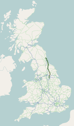
The A19 is a major road in England running approximately parallel to and east of the A1 road. Although the two roads meet at the northern end of the A19, the two roads originally met at the southern end of the A19 in Doncaster, but the old route of the A1 was changed to the A638. From Sunderland northwards, the route was formerly the A108. In the past the route was known as the East of Snaith-York-Thirsk-Stockton-on-Tees-Sunderland Trunk Road. Most traffic joins the A19, heading for Teesside, from the A168 at Dishforth Interchange.
The A49 is an A road in western England, which traverses the Welsh Marches region. It runs north from Ross-on-Wye in Herefordshire via Hereford, Leominster, Ludlow, Shrewsbury and Whitchurch, then continues through central Cheshire to Warrington and Wigan before terminating at its junction with the A6 road just south of Bamber Bridge, near the junction of the M6, M65 and M61 motorways.
The A52 is a major road in the East Midlands, England. It runs east from a junction with the A53 at Newcastle-under-Lyme near Stoke-on-Trent via Ashbourne, Derby, Stapleford, Nottingham, West Bridgford, Bingham, Grantham, Boston and Skegness to the east Lincolnshire coast at Mablethorpe. It is approximately 147 miles (237 km) long.
The A217 is a road in London and Surrey in England. It runs north–south. It runs from Kings Road in Fulham, London, crosses the Thames at Wandsworth Bridge, then passes through Wandsworth, Earlsfield, Summerstown, Tooting, Mitcham, Rosehill and Sutton Common in Sutton, then Cheam. Then, widened as a dual carriageway, comes Belmont, a suburban district built on a slope rising southward. On the North Downs in Surrey the road then skirts past Banstead and through its late 19th century offspring villages particularly Burgh Heath and Kingswood, Surrey. It then crosses the M25 motorway at Junction 8, then, returning to single carriageways, passes through the castle town of Reigate. It then cuts through the green buffer farmland of two rural villages and terminates at the road network at Gatwick Airport's northern perimeter.
The A308 is a road in England in two parts. The first part runs from Central London to Putney Bridge. The second part runs from just beyond Putney Heath to Bisham, Berkshire. It traces four, roughly straight lines, to stay no more than 3 miles (4.8 km) from the Thames. It is a dual carriageway where it is furthest from that river, in Spelthorne, Surrey and forms one of the motorway spurs to the large town of Maidenhead. Other key settlements served are Fulham, Kingston (London), Staines upon Thames, Windsor and a minor approach to Marlow
The A120 is an A-road in England, which runs between Puckeridge in Hertfordshire and Harwich in Essex.
The A1231 road connects Sunderland and Washington in Tyne and Wear, North East England. It is the main road connecting these towns and is one of the main roads giving access to Sunderland city centre.
The A1018 is a road in North East England. It runs between South Shields, at the mouth of the River Tyne, and the A19 near Seaham, County Durham. Most of the route it follows is the old alignment of the A19, before it by-passed Sunderland to meet the Tyne Tunnel.
The A1300 is the main 'cross town' route in South Shields, Tyne and Wear. The road runs from Simonside to Marsden via Harton Nook. It is 3.7 miles (6 km) long.
The A727 road in Scotland runs from East Kilbride in South Lanarkshire, through East Renfrewshire, to Junction 3 of the M77 motorway in Glasgow.
The A6102 is a 4 digit A road in South Yorkshire, England.
The A1 road around Gateshead and Newcastle upon Tyne after arriving from the south as the A1(M) from its origin in London, currently runs from the A1(M) terminus at Birtley. It then swings to the west of both Gateshead and Newcastle via Coal House, Lobley Hill, Metrocentre, Swalwell, Blaydon Bridge, West Denton, Fawdon and Wideopen to Seaton Burn interchange before continuing north towards Edinburgh.