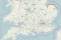
The A149 is commonly known as "The Coast Road" to local residents and tourists, as this road runs along the North Norfolk coast from King's Lynn to Great Yarmouth, via coastal villages.
The road begins in King's Lynn on a roundabout with the A148 London Road and Nar Ouse Way and begins southbound out of King's Lynn. It runs over a railway bridge then past a Tesco Supermarket. It then reaches a major junction with the A47 and the A10 at a roundabout. It becomes a primary route heading north on Queen Elizabeth Way. This serves as an eastern bypass for King's Lynn. The road reaches a roundabout with the A1076 and the B1145 towards Gayton. The road continues as a primary route until Grimston Road Roundabout where the road becomes a secondary route. If you were to travel west along the A148, you would reach the centre of King's Lynn. Travelling east along the A148 would get you to Fakenham and Holt before reaching Cromer. When going from Lynn to Cromer, it is advisable to use the A148 to provide a faster straighter route.
Continuing north along the A149 will take you towards the North Norfolk Coast and is usually signposted for Heacham or Hunstanton. The road passes the historic Castle Rising castle and past Sandringham House and estate, shortly followed by Dersingham. Snettisham is about 3 miles along the road. Snettisham has an RSPB Wildlife Reserve that throughout the year is a habitat for birds, often migrating from the north over the North Sea. The RSPB have compiled a list of "star species", that include the avocet.[1]
The road continues onto Heacham and has a roadside petrol station, owned by BP. There is also a newly built lidl here and they are situated almost next to each other. The road passes a junction with a road to Bircham, and a road into the centre of the town, with links to the beach. This road, as it has done since pre-Georgian era,[2] has been a connection for Heacham, Snettisham, Sandringham. The A149 in Heacham is now a bypass. There have been some record of this road being a Roman Road.
The road at Heacham looking back towards the so-called Lavendar Junction
The road continues to Hunstanton past Norfolk Lavender. Hunstanton is a seaside resort with a beach which is popular for Fossil hunting in and around the cliffs. Also, the town is quite large with many local shops, including Britain's Largest Joke Shop and a Tesco Supermarket.
Hunstanton to Brancaster
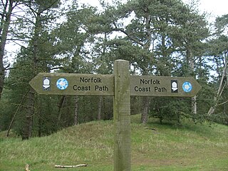
After Hunstanton is Old Hunstanton. The road continues around the coast, following the same sand covered beach as the one in Heacham. From Hunstanton to Brancaster is 13 miles long. The road narrows slightly, it is still a single carriageway road. The road this time does not bypass the villages, but goes through them, providing access to the village. The villages here often contain independent restaurants, shops and grocery stores. Pubs are a common feature here too. The village following Old Hunstanton is Holme-Next-The-Sea, a coastal village situated on marshes and Creakes where boats are often sailed. Beyond the marsh is a large sand dune, known as "Holme Dunes". Part of this is protected by the NWT (Norfolk Wildlife Trust) as a protection for species that nest here. Being situated next to the North Sea, many birds come and migrate for the summer or winter here. At Holme Dunes, there have been sightings of the wryneck and even the extremely rare Ruppell's warbler. Also protected are natterjack toads, edible crabs and waders.[3] Holme is also the end of Peddars Way and is the junction with the Norfolk Coast Path. Following this ancient Roman Road southbound will bring you to Thetford passing through the Brecklands. Peddars Way may have run to Branodunum, a Roman fort along this road. Following Holme's Main Road is the village of Thornham. The name of the road here is High Street, as it is the main road through the village. Separating Holme and Thornham are the marshes. There is a small staithe here, as there is throughout the north-west Norfolk area. Thornham village has access to the staithe via Staithe Road, which connects to the A149. Crabs nest in the muddy banks in the creeks, and when there is High Tide, the marsh often floods and the banks of these rivers overflow. The village and road is protected by farmland either side. The village of Thornham is approximately 1 mile long and hosts an independent delicatessen and cafe along with a pick your own fruit farm cum orchard. About 2 miles on is Titchwell. There is an RSPB reserve here that has been featured in the BBCsSpringwatch. The Norfolk Coastal path runs through this village further towards the beach, and has been transformed into an embankment as coastal defence. This continues through North Norfolk to beyond Cromer. This acts as protection to the rising tides, and flooding. On the beach, prehistoric forests can be seen at low tide, and archaeological digs have found mesolithic flint submerged. In Titchwell Marsh and on the beach, medieval pottery has also been found. Sightings at Titchwell Marsh have been marsh harriers and bitterns[4] Like in Snettisham, a list of "star species" has been compiled.
Not far along the A149 is the village of Brancaster, a Roman town with the name Branodunum, meaning "Fortress of Bran". This was a place of Roman importance, and may have been where footpath, Peddars Way led. Now, the village marshes are owned by the National Trust and are kept as conservation areas. There is a long beach, and access to Titchwell beach is restricted due to a large creek. The sand beach is one that again, spans the length of the coast. Tides are strong and there is a memorial to the death of Jake Parker, 5, who drowned near the village. Brancaster currently hosts a pub, church and hotel.
The Listed AA Box at Brancaster
Brancaster to Wells (The Burnhams and Holkham)
The road continues following the coast. The road widens slightly between Brancaster and Deepdale. The road runs around a mile inland from the Norfolk Coast Path at this point. The marshes continue, as do the little Staithes. The next village after Brancaster, is Brancaster Staithe. This is a larger staithe, and runs to the west of Scolt Head Island. Sailing is often enjoyed here. In Brancaster Staithe, there are small shops and stalls connected to houses. There is also a small church. Access to the beach beyond the staithe can be restricted due to there being no road direct to the beach, though access can be made by walking along Brancaster Beach. Burnham Deepdale follows Brancaster Staithe if travelling eastbound. Deepdale is the next Petrol Station after Heacham for 12 miles. The Murco petrol station has shops next to it. These include the "Deepdale Cafe", Fat Face and a Tourist Information Centre. North of this road are the Salt Marshes and Mow Creek, the creek that connects Brancaster Staithe to this village. Sailing is also available here. At the west end of Deepdale is a minor road leading to the B1155 in Burnham Market, a town made up of 3 of the older Burnhams: Ulph, Sutton and Westgate. The road narrows and heads southbound for about a mile as the road bypasses Burnham Norton. The B1355 southbound brings you to Fakenham via Burnham Market and provides lorry access to Cromer as the road beyond here is inaccessible to lorries. Following the Salt Marshes and Saithes, the road heads north again and bears east as it enters Burnham Overy Staithe, passing the River Burn, of which the Burnhams are named. The road narrows and has a width restriction of 2 meters. The road then comes out passing a green and village; Burnham Overy Staithe. This village is a popular sailing village with a boathouse shop and pub. It is said that Lord Nelson learned to sail here,[5] hence the name of the pub, "The Hero", situated on the A149 itself. There is a walk to the beach along the Norfolk Coast Path, that is about a mile long. Also, a ferry is available to Scolt Head Island.
Continuing on the A149, the road runs south of salt marshes, but no Staithe. The land to the north is owned by Viscount Coke as part of the Holkham Estate, situated on the next village. If HGV access is required to King's Lynn, the B1155 to Burnham Market will take you there. The road passes more Salt Marshes to the north, and pine forests to the south. A wall separates the estate from the road. Holkham estate was purchased by Sir Edward Coke in 1909, and Holkham Hall was completed in 1764.[6] The A149 has a further crossroads, allowing access to the house southbound, and access to the beach northbound. The beach is owned by Holkham Estates Limited. Holkham has museums, shops, cafes and a pub as a result of the manor. The village is small. Following the road around, you arrive in Wells-Next-The-Sea, a town in North Norfolk. The road is built on a small raised bed to prevent flooding as it runs through marshes. This marsh is flat and runs from the dunes in Holkham to the woodland on the estate the other side of Wells. The A149 does not enter Wells, but the B1105 does. It is often signposted as the A149 in the centre of the town. Wells has many shops and is popular for fish and chips. Wells has a harbour and gillying is an activity undertaken commonly. The A149 bypasses Wells on its south side. There is a T junction, eastbound continues on the A149, signposted "Stiffkey" and the right of way is southbound becomes the B1105 and northbound becomes the A149.
Wells next the Sea to Cromer
Just out of Wells, the road passes on the right, the Wells and Walsingham Light Railway. From here the road runs south of Stiffkeysalt marshes. This stretch of the road runs parallel with the "Peddars Way" section of the North Norfolk Coastal Path, which is about 1⁄4 mile (0.40km) north and runs along the fringe of the marshes. In Stiffkey, the road narrows to a single lane causing approaching traffic to give way. Beyond the village the road crosses the River Stiffkey. The next village on the road is Morston (38 miles (61km) from the start), The road skirts around the south of the village.
Cley Windmill from the A149
After Blakeney, the road descends into the Glaven Valley, and into view comes the landmark of Cley next the SeaWindmill. Again the road becomes a bottle neck in the summer months as it pass through the village of Cley next the Sea. The next stretch of the road between Cley and Sheringham is a very scenic part of the A149. After negotiating the narrow streets of Cley the road runs along the coast south of Cley and Salthouse salt marshes, the sea is hidden by a long bank of shingle that runs along the shoreline here. The marshes are a Nature Reserve and all along this stretch of the road there are lay-bys and car parks which are used as viewing points.
The road now rises away from the marshes and twists and turns into the next village of Kelling. The road now passes through the gentle and heaths of Kelling Heath and Weybourne. Just before entering the village of Weybourne, the road passes Weybourne Camp on the left. The road now passes through the village of Weybourne (45.5 miles (73.2km)) and up a hill past the village Windmill.
The road near Sheringham Park and the National Trust
As the road stretches off to Sheringham it passes under a railway bridge carrying the North Norfolk Railway. The road now passes through a stretch of land that is owned by The National Trust. As then runs right alongside the A149, squeezed between the road and the Sheringham Golf Club which is set on the cliffs in an Area of Outstanding Natural Beauty. The mini roundabout at Sheringham it is 48.2 miles (77.6km) from the start of the A149 at King's Lynn.
The A149 east into Sheringham
Sheringham is a seaside resort. The route now passes the terminus for the North Norfolk Railway on the left. The A149 runs south of the heart of the town, passing the prominent hill on the left known locally as "Beeston Bump". The road now also has a railway line running parallel on the seaward side. At 49 miles (79km) the road reaches the village of Beeston Regis followed by West Runton. The last village before Cromer is East Runton were the landscape of the coast is peppered with static caravans or mobile homes. The A149 now reaches the fading Victorian splendour of Cromer (52.3 miles (84.2km)). The road drops down into the town, with a splendid view of the town's pier, where it dog-legs through the town's one way system. This part of the road becomes congested in the summer months and long queues form in the one-way system. Cromer marks the end of the roads route along the coast, as it turns south-east to cut across Norfolk towards its end at Great Yarmouth.
Cromer to Stalham
The road climbs a hill southwards, out of Cromer, past Cromer Academy towards the next village of Northrepps and past the turning on the right of the A140 which is the main road to Norwich. Passing through well ordered arable farmland the road then reaches a cross roads, with the B1436 just before the village of Thorpe Market. The B1436 links the Cromer-Holt road to Mundesley on the coast. Out of the village the road runs along the boundary of Gunton Park, with some 800 acres (3.2km2) of deer park, on the right. Further on is the village of Antingham before reaching North Walsham, (61 miles (98km) from King's Lynn). At North Walsham there is a junction controlled with traffic lights. Here the road turn right and takes a new route around the western side of the Town, past the Bacton Gas terminal's link to the rail network. The old route would have taken you through the busy town centre. This new route runs part of the way along what was the disused track bed of the Midland and Great Northern Joint Railway (M&GN) railway between Stalham and North Walsham. Heading towards the Norfolk Broads (part of the Norfolk and Suffolk Broads Authority[7], the road passes the villages of Worstead and Dilham and then passes through Smallburgh were the road clips The Broads. Just past Smallburgh the road turns left at a T junction. The road to the right is the A1151, from Wroxham and Norwich, which terminates at this junction. The road now takes a large north easterly arch around Barton Broad, crossing the River Ant at Wayford Bridge. The road now curves back towards Stalham passing several boat hire yards. Stalham is 69 miles (111km) from the start of the A149, and from here the road cuts across the flatlands of Norfolk skirting the Broads as it goes.
Stalham, across the broads to Great Yarmouth
Potter Heigham Bridge next to the modern bridge of the A149
Long straights characterise this 5-mile (8.0km) stretch from Stalham to Potter Heigham. The straights pass through the villages of Sutton and Catfield. This part of the A149 has a bad reputation for fatalities and care should be taken at all the junctions that dissect this 5-mile (8.0km) stretch. Most of this section is not the original route of the road. The original road runs parallel on the right, the new route effectively by-passing out the villages, and at Potter Heigham Bridge (74 miles (119km)) the two roads converge. After Potter Heigham the next village is Repps with Bastwick followed by Rollesby (77 miles (124km)). At Rollesby the road crosses Ormesby Broad were there is parking if you wish to visit this Broad. Past the large water works on the left and the road now passes through Ormesby St. Michael and then Ormesby St. Margaret. Before coming to another roundabout junction. This is the terminus of the A1064 which has come across the Broads from Acle a distance of 7.2 miles (11.6km) in all. Looking straight across the roundabout is the site of Caister Castle. The A149 is now a Dual Carriageway and, at another junction, bypasses Caister-on-Sea. After the bypass, the road narrows back to a Single Carriageway as it enters Great Yarmouth. The road now heads south, past Yarmouth Stadiumgreyhound racing track and stadium, and the Heliport at North Denes Airfield, on the right. At the next set of traffic lights is Jellicoe Road, leading to Great Yarmouth Horse Racecourse. The road follows the east bank of the River Bure. At the large roundabout the A149 comes to an end, and joins the A47 road at the northern side of the Breydon Bridge, close to Great Yarmouth railway station. The total distance from Hardwick flyover to this roundabout in Great Yarmouth is 85.237 miles (137.176km) (Goggle Pedometer).
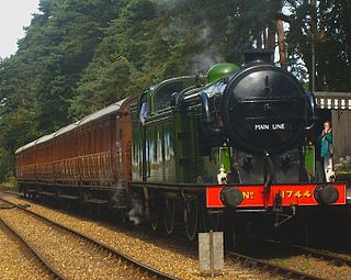
The North Norfolk Railway (NNR) – also known as the "Poppy Line" – is a 5+1⁄4-mile (8.4 km) heritage steam railway in Norfolk, England, running between the towns of Sheringham and Holt. The North Norfolk Railway is owned and operated as a public limited company, originally called Central Norfolk Enterprises Limited. The railway is listed as exempt from the UK Railways (Interoperability) Regulations 2000.
Hunstanton is a seaside town in Norfolk, England, which had a population of 4,229 at the 2011 Census. It faces west across The Wash. Hunstanton lies 102 miles (164 km) north-north-east of London and 40 miles (64 km) north-west of Norwich.
Holkham National Nature Reserve is England's largest national nature reserve (NNR). It is on the Norfolk coast between Burnham Overy Staithe and Blakeney, and is managed by Natural England with the cooperation of the Holkham Estate. Its 3,900 hectares comprise a wide range of habitats, including grazing marsh, woodland, salt marsh, sand dunes and foreshore. The reserve is part of the North Norfolk Coast Site of Special Scientific Interest, and the larger area is additionally protected through Natura 2000, Special Protection Area (SPA) and Ramsar listings, and is part of both an Area of Outstanding Natural Beauty (AONB) and a World Biosphere Reserve. Holkham NNR is important for its wintering wildfowl, especially pink-footed geese, Eurasian wigeon and brant geese, but it also has breeding waders, and attracts many migrating birds in autumn. Many scarce invertebrates and plants can be found in the dunes, and the reserve is one of the only two sites in the UK to have an antlion colony.
The Norfolk Coast Path is a long-distance footpath in Norfolk, running 83 miles (133.5 km) from Hunstanton to Hopton-on-Sea. It was opened in 1986 and covers the North Norfolk Coast AONB.
The Norfolk Burnhams are a group of adjacent villages on the north coast of Norfolk, England. The villages are located near a large natural bay named Brancaster Bay and the Scolt Head Island National Nature Reserve.
Brancaster is a village and civil parish on the north coast of the English county of Norfolk. The civil parish of Brancaster comprises Brancaster itself, together with Brancaster Staithe and Burnham Deepdale. The three villages form a more or less continuous settlement along the A149 at the edge of the Brancaster Manor marshland and the Scolt Head Island National Nature Reserve. The villages are located about 3 miles (4.8 km) west of Burnham Market, 22 miles (35 km) north of the town of King's Lynn and 31 miles (50 km) north-west of the city of Norwich. The civil parish has an area of 8.27 square miles (21.4 km2) and in the 2011 census had a population of 797 in 406 households. For the purposes of local government, the parish falls within the district of King's Lynn and West Norfolk. In 2016, Janet Lake, the clerk to Brancaster Parish Council, reached 50 years of service in the post.
Brancaster Staithe is a village on the north coast of the English county of Norfolk. Brancaster Staithe merges with Burnham Deepdale, forming one village.
Burnham Deepdale is a village and former civil parish, now in the parish of Brancaster, in the King's Lynn and West Norfolk district, on the north coast of the county of Norfolk, England. Burnham Deepdale, Brancaster and Brancaster Staithe form a more or less continuous settlement along the A149, at the edge of the Brancaster Manor marshland and the Scolt Head Island National Nature Reserve. In 1931 the parish had a population of 81.
Kelling is a village and a civil parish in the English county of Norfolk. The village is 10.1 miles (16.3 km) west of Cromer, 26 miles (42 km) north of Norwich, and 130 miles (210 km) northeast of London. The village straddles the A149 Coast road between Kings Lynn and Great Yarmouth.
The A1065 is a main road in the English region of East Anglia. It provides the principal road connection to parts of the west and north of the county of Norfolk from Newmarket and points south of there, including London. It runs from a junction near Mildenhall, to a junction on the western outskirt of Fakenham.
Heacham River is a small river in the King's Lynn and West Norfolk district of the English County of Norfolk. Its source is near the village of Bircham Newton grid reference TF762 339, 25 metres above sea level. The river is 16.4 kilometres (10.2 mi) long from the source to the outfall on Heacham beach, which discharges into The Wash at low tide.
Burnham Market was a railway station which served the village of Burnham Market, Norfolk, England. Opened by the West Norfolk Junction railway in 1866, it closed with the line in 1952.
The West Norfolk Junction Railway was a standard gauge eighteen and a half-mile single-track railway running between Wells-next-the-Sea railway station and Heacham in the English county of Norfolk. It opened in 1866 and closed in 1953. At Wells the line made a junction with the Wells and Fakenham Railway and at Heacham it connected with the line from Hunstanton to Kings Lynn.
The North Norfolk Coast Site of Special Scientific Interest (SSSI) is an internationally important protected area in Norfolk, England. The SSSI is a long, narrow strip of coastal land that starts between Old Hunstanton and Holme-next-the-Sea, and runs east for about 43 km (27 mi) to Kelling. The southern boundary runs roughly west to east except where it detours around towns and villages, and never crosses the A149 coast road. It has an area of 7,700 ha (19,027 acres), and is additionally protected through Natura 2000, Special Protection Area (SPA) and Ramsar listings; it is also part of the Norfolk Coast Area of Outstanding Natural Beauty (AONB). Scolt Head Island and the coast from the Holkham National Nature Reserve to Salthouse are a Biosphere Reserve.
The North Norfolk Coast Site of Special Scientific Interest (SSSI) is an area of European importance for wildlife in Norfolk, England. It comprises 7,700 ha (19,027 acres) of the county's north coast from just west of Holme-next-the-Sea to Kelling, and is additionally protected through Natura 2000, Special Protection Area (SPA) listings; it is also part of the Norfolk Coast Area of Outstanding Natural Beauty (AONB). The North Norfolk Coast is also designated as a wetland of international importance on the Ramsar list and most of it is a Biosphere Reserve.
Cley Marshes is a 176-hectare (430-acre) nature reserve on the North Sea coast of England just outside the village of Cley next the Sea, Norfolk. A reserve since 1926, it is the oldest of the reserves belonging to the Norfolk Wildlife Trust (NWT), which is itself the oldest county Wildlife Trust in the United Kingdom. Cley Marshes protects an area of reed beds, freshwater marsh, pools and wet meadows and is part of the North Norfolk Coast Site of Special Scientific Interest (SSSI), Special Area of Conservation (SAC), Special Protection Area (SPA), and Ramsar Site due to the large numbers of birds it attracts.
The Lynn and Hunstanton Railway was a line in Norfolk, England that opened in 1862. The railway was a major factor in developing Hunstanton as a seaside resort and residential community. The company was allied to the West Norfolk Junction Railway which built a line connecting Heacham, south of Hunstanton, to Wells-next-the-Sea that was not a financial success. The companies amalgamated in 1874 to form the Hunstanton and West Norfolk Railway, and in 1890 the company was sold to the Great Eastern Railway.
↑ http://www.historic-maps.norfolk.gov.uk/ Here is where the Historic Norfolk interactive map is on the North Norfolk County Council Website. Data from Tithe map and Boundary map. Flash is needed to view this application.
↑ "Holme Dunes"(PDF). Archived from the original(PDF) on 10 November 2013. Retrieved 15 August 2012. Please see this brochure for more information about species protected and sightings in the dunes from NWT
↑ "Brancaster Staithe". Archived from the original on 18 October 2011. Retrieved 3 August 2012. Lord Nelson learned to sail in the Staithe, This is a reference to Brancaster Staithe. This is connected with Burnham Overy
This page is based on this Wikipedia article Text is available under the CC BY-SA 4.0 license; additional terms may apply. Images, videos and audio are available under their respective licenses.