The Ridgeway is a ridgeway or ancient trackway described as Britain's oldest road. The section clearly identified as an ancient trackway extends from Wiltshire along the chalk ridge of the Berkshire Downs to the River Thames at the Goring Gap, part of the Icknield Way which ran, not always on the ridge, from Salisbury Plain to East Anglia. The route was adapted and extended as a National Trail, created in 1972. The Ridgeway National Trail follows the ancient Ridgeway from Overton Hill, near Avebury, to Streatley, then follows footpaths and parts of the ancient Icknield Way through the Chiltern Hills to Ivinghoe Beacon in Buckinghamshire. The National Trail is 87 miles (140 km) long.
The Norfolk Coast Path is a long-distance footpath in Norfolk, running 83 miles (133.5 km) from Hunstanton to Hopton-on-Sea. It was opened in 1986 and covers the North Norfolk Coast AONB.
National Trails are long distance footpaths and bridleways in England and Wales. They are administered by Natural England, a statutory agency of the UK government, and Natural Resources Wales, a Welsh Government-sponsored body.
Knettishall Heath is a 91.7 hectare biological Site of Special Scientific Interest west of Knettishall in Suffolk. A larger area of 176 hectares is the Knettishall Heath Nature Reserve, which is managed by the Suffolk Wildlife Trust.

The Icknield Way is an ancient trackway in southern and eastern England that runs from Norfolk to Wiltshire. It follows the chalk escarpment that includes the Berkshire Downs and Chiltern Hills.
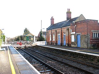
Harling Road railway station is on the Breckland line in the east of England, serving the villages of Larling, Roudham and East Harling, Norfolk. The line runs between Cambridge in the west and Norwich in the east.

Beeston Regis is a village and civil parish in the North Norfolk district of Norfolk, England. It is about a mile (2 km) east of Sheringham, Norfolk and near the coast. The village is 2 miles (3 km) west of Cromer and 16 miles (26 km) north of the city of Norwich. According to the 2011 census it had a population of 1,062. There is a frequent bus service on the coast road A149 and a rail service from the nearby stations of Sheringham to the west and West Runton to the east, where the Bittern Line runs a frequent service between Norwich, Cromer and Sheringham. The nearest airport is Norwich International Airport.

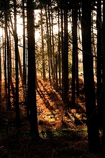
Breckland in Norfolk and Suffolk is a 39,433 hectare Special Protection Area (SPA) under the European Union Directive on the Conservation of Wild Birds. The SPA partly overlaps the 7,544 hectare Breckland Special Area of Conservation. As a landscape region it is an unusual natural habitat of England. It comprises the gorse-covered sandy heath that lies mostly in the south of the county of Norfolk but also in the north of Suffolk. An area of considerable interest for its unusual flora and fauna, it lies to the east of another unusual habitat, the Fens, and to the south west of the Broads. The typical tree of this area is the Scots pine. Breckland is one of the driest areas in England.
The Greater Ridgeway, also known as the Great Chalk Way, is a 362-mile long-distance footpath crossing England from Lyme Regis in Dorset to Hunstanton in Norfolk. It is a combined route which is made by joining four long-distance footpaths: the Wessex Ridgeway, The Ridgeway National Trail, the Icknield Way and the Peddars Way National Trail.
The following are lists of recreational walks in Norfolk, England.

Wingfield is a hamlet located in the Central Bedfordshire district of Bedfordshire, England.
The Hereward Way is a long-distance footpath in England that links the Viking Way at Oakham with the Peddars Way at Knettishall Heath, near Thetford.

The Angles Way is a long-distance footpath in England, close to the River Waveney and River Little Ouse and thus close to the Norfolk/Suffolk border between Great Yarmouth and Thetford.
The Iceni Way is a collective name for several long-distance footpaths running from Knettishall Heath to Hunstanton via the Little Ouse and Great Ouse valleys in the English county of Norfolk. There are links with the Fen Rivers Way, Hereward Way, Icknield Way Path, Little Ouse Path and Nar Valley Way. The name comes from the Iceni tribe that once lived in the area.

The A149 is commonly known as "The Coast Road" to local residents and tourists as this road runs along the North Norfolk coast from King's Lynn to Cromer passing through small coastal villages. The road then leaves the coastline at Cromer and reaches the Norfolk Broads.

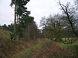
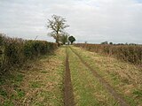
The Icknield Way Path or Icknield Way Trail is a long distance footpath in East Anglia, England. The ancient Icknield Way itself is unique among long-distance trails because it can claim to be ‘the oldest road in Britain’. It consists of prehistoric pathways, ancient when the Romans came; the route is dotted with archaeological remains. It survives today in splendid tracks and green lanes along the ‘chalk spine’ of southern England.
North Pickenham is a village in the Breckland district of mid-Norfolk, East Anglia, England. It lies three miles from the Georgian market town of Swaffham.
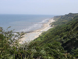
The Norfolk Coast Area of Outstanding Natural Beauty is a protected landscape in Norfolk, England. It covers over 450 km2 of coastal and agricultural land from The Wash in the west through coastal marshes and cliffs to the sand dunes at Winterton in the east. It was designated AONB in 1968, under the National Parks and Access to the Countryside Act 1949.
The National Cycle Route 13 is a cycling route that is part of the National Cycle Network in the United Kingdom. It connects Tower Bridge in London with Fakenham in Norwich.

Icklingham is a village and civil parish in the West Suffolk district of Suffolk in eastern England. It is located about 7 miles (11 km) north-west of Bury St Edmunds, 4 miles (6.4 km) south-east of Mildenhall and 9 miles (14 km) south-west of Thetford in Norfolk. The village is on the A1101 road between Bury St Edmunds and Mildenhall in the north-west of the county. The area around the village, characterised by a sandy gravel-laden soil, is known as Breckland, though an arm of the fen-like peat follows the River Lark past the village.