Knettishall Heath

Last updated

Knettishall Heath
Site of Special Scientific Interest
Knettishall Heath Country Park - geograph.org.uk - 32235.jpg
Location Suffolk
Grid reference TL 951 804 [1]
InterestBiological
Area91.7 hectares [1]
Notification 1984 [1]
Location map Magic Map

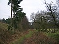
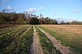
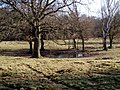
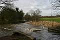
Knettishall Heath is a 91.7-hectare (227-acre) biological Site of Special Scientific Interest west of Knettishall in Suffolk. [1] [2] A larger area of 176 hectares is the Knettishall Heath Nature Reserve, which is managed by the Suffolk Wildlife Trust. [3]

Contents

Despite its name, Knettishall Heath is in fact a diverse mosaic of habitats with woodland and riverside meadows, as well as large areas of heath. [4]

Ecology

The site is heath and grassland, mainly on acidic soils, with areas of secondary woodland and wet hollows. There are heathland plants such as sheep's sorrel, tormentil, harebell, ling and heath bedstraw, while wet areas have fen vegetation including water mint and yellow iris. [5]

Rare species

Of the more than 12,500 species living in the Brecks, 30% are nationally rare. The heath is home to the rare grey carpet moth which is only found in Breckland, and the lunar yellow underwing moth. Seven bat species are found at Knettishall, including the nationally scarce barbastelle bat.

Exmoor ponies

In 2013, a five-year funded project to restore lowland heath at the nature reserve began. As part of this project, 19 wild Exmoor ponies have roamed and grazed the land, helping other species to thrive. The 'Vision for the Future' project was funded by the Heritage Lottery Fund and WREN - a not-for-profit organisation that offers grants for heritage and biodiversity schemes.

Exmoor pony grazing heath Exmoor pony at Slovicky vrch, Dobrany, 2019-02-23, 01.jpg
Exmoor pony grazing heath

The shrinkage of heathland has been caused partially by a decline in rabbits grazing; rabbit populations have been decimated by myxomatosis and more recently rabbit haemorrhagic disease (RHD). The addition of ponies grazing the heathland looks to reverse this shrinkage. [6]

Archaeology

An 18th century rabbit warren and a Bronze Age burial mound at Hut Hill are evidence of thousands of years of human occupation in the area.

At the western end of the heath, ‘patterned ground’ shows evidence of the last ice age. Repeated freezing and thawing of ground created a unique mix of the sandy soil and the underlying chalk. Unusual vegetation stripes reflect the two soil types, and the different plants that grow in each. [7]

Footpaths

It is the site where four long-distance footpaths meet: Angles Way, Icknield Way, Iceni Way and Peddars Way (part of the Norfolk Coast Path, a National Trail). The Icknield Way joins with the Peddars Way at the end of its 110 miles (180 km) journey from Ivinghoe Beacon in Buckinghamshire. The Icknield Way trail, a multi-user route for walkers, horse riders and off-road cyclists also joins with the Peddars Way riders route. [8]

The Hereward Way ends nearby in East Harling, and it linked to Knettishall Heath by path.

Access

There are several access points to the heathland, most found off the road between Knettishall and Rushford villages. The main car park for the area can be found on an unnamed road (informally known as Heath Road) off Spalding's Chair Hill.

The A1066 passes within a mile or two of the heathland, where it runs from Thetford to Garboldisham.

Related Research Articles

<span class="mw-page-title-main">Redgrave and Lopham Fens</span>

Redgrave and Lopham Fens is a 127 hectare biological Site of Special Scientific Interest between Thelnetham in Suffolk and Diss in Norfolk. It is a national nature reserve, a Ramsar internationally important wetland site, a Nature Conservation Review site, Grade I, and part of the Waveney and Little Ouse Valley Fens Special Area of Conservation. It is managed by the Suffolk Wildlife Trust.

<span class="mw-page-title-main">Peddars Way</span> Long-distance footpath in England

The Peddars Way is a long distance footpath that passes through Suffolk and Norfolk, England.

<span class="mw-page-title-main">Chobham Common</span> Location near Chobham, Surrey, of a British tank research centre

Chobham Common is a 655.7-hectare (1,620-acre) biological Site of Special Scientific Interest north of Chobham in Surrey. It is a Nature Conservation Review site, Grade I and a national nature reserve. It is part of the Thames Basin Heaths Special Protection Area and the Thursley, Ash, Pirbright and Chobham Special Area of Conservation. It contains three scheduled monuments. Most of the site is managed by the Surrey Wildlife Trust as the Chobham Common nature reserve, but the SSSI also includes a small private reserve managed by the Trust, Gracious Pond.

<span class="mw-page-title-main">Suffolk Wildlife Trust</span>

Suffolk Wildlife Trust (SWT) describes itself as the county's "nature charity – the only organisation dedicated wholly to safeguarding Suffolk's wildlife and countryside." It is a registered charity, and its headquarters is at Brooke House in Ashbocking, near Ipswich. It was founded in 1961, and is one of 46 wildlife trusts covering the Great Britain and Northern Ireland. As of March 2017, it has 13,200 members, and it manages 3,120 hectares of land in 60 nature reserves, most of which are open to the public. It had an income of £3.9 million in the year to 31 March 2017.

<span class="mw-page-title-main">Breckland</span> Natural region in Norfolk and Suffolk, UK

Breckland in Norfolk and Suffolk is a 39,433 hectare Special Protection Area (SPA) under the European Union Directive on the Conservation of Wild Birds. The SPA partly overlaps the 7,544 hectare Breckland Special Area of Conservation. As a landscape region it is an unusual natural habitat of England. It comprises the gorse-covered sandy heath that lies mostly in the south of the county of Norfolk but also in the north of Suffolk. An area of considerable interest for its unusual flora and fauna, it lies to the east of another unusual habitat, the Fens, and to the south west of the Broads. The typical tree of this area is the Scots pine. Breckland is one of the driest areas in England.

The following are lists of recreational walks in Norfolk, England.

<span class="mw-page-title-main">Angles Way</span> Long-distance footpath in England

The Angles Way is a long-distance footpath in England, close to the River Waveney and River Little Ouse and thus close to the Norfolk/Suffolk border between Great Yarmouth and Thetford.

The Iceni Way is a collective name for several long-distance footpaths running from Knettishall Heath to Hunstanton via the Little Ouse and Great Ouse valleys in the English county of Norfolk. There are links with the Fen Rivers Way, Hereward Way, Icknield Way Path, Little Ouse Path and Nar Valley Way. The name comes from the Iceni tribe that once lived in the area.

<span class="mw-page-title-main">Icknield Way Path</span> Long-distance footpath in East Anglia, England

The Icknield Way Path or Icknield Way Trail is a long distance footpath and riding route in East Anglia, England. The ancient Icknield Way itself is unique among long-distance trails because it can claim to be ‘the oldest road in Britain’. It consists of prehistoric pathways, ancient when the Romans came; the route is dotted with archaeological remains. It survives today in splendid tracks and green lanes along the ‘chalk spine’ of southern England.

<span class="mw-page-title-main">Icklingham</span> Human settlement in England

Icklingham is a village and civil parish in the West Suffolk district of Suffolk in eastern England. It is located about 7 miles (11 km) north-west of Bury St Edmunds, 4 miles (6.4 km) south-east of Mildenhall and 9 miles (14 km) south-west of Thetford in Norfolk. The village is on the A1101 road between Bury St Edmunds and Mildenhall in the north-west of the county. The area around the village, characterised by a sandy gravel-laden soil, is known as Breckland, though an arm of the fen-like peat follows the River Lark past the village.

<span class="mw-page-title-main">Euston, Suffolk</span> Human settlement in England

Euston is a village and civil parish in the West Suffolk district of Suffolk in eastern England. Located on the A1088 around two miles south of Thetford, in 2005 its population was 130.

<span class="mw-page-title-main">Highgate Common</span>

Highgate Common is a Staffordshire Wildlife Trust reserve containing a mix of heathland and woodland. It is about 129 hectares or 320 acres in size. The common is a popular leisure destination and a Site of Special Scientific Interest, located in Southern Staffordshire, England.

<span class="mw-page-title-main">Galley and Warden Hills</span>

Galley and Warden Hills is a 47 hectare biological Site of Special Scientific Interest in Warden Hill, a suburb of Luton in Bedfordshire. The local planning authority is Central Bedfordshire Council, and it was notified in 1986 under Section 28 of the Wildlife and Countryside Act 1981. It is also a Local Nature Reserve.

<span class="mw-page-title-main">Wangford Warren and Carr</span>

Wangford Warren and Carr is a 67.8-hectare (168-acre) biological Site of Special Scientific Interest between Brandon and Lakenheath in Suffolk. It is a Nature Conservation Review site, Grade I, and part of the Breckland Special Area of Conservation, and Special Protection Area An area of 15 hectares is managed as a nature reserve by the Suffolk Wildlife Trust

<span class="mw-page-title-main">Blaxhall Common</span>

Blaxhall Common is a nature reserve in the parish of Blaxhall in the East Suffolk District of Suffolk. The reserve is owned by Blaxhall Parish Council and managed by Suffolk Wildlife Trust. It is designated a 45.9-hectare (113-acre) biological Site of Special Scientific Interest as Blaxhall Heath. It is part of the Sandlings Special Protection Area under the European Union Directive on the Conservation of Wild Birds, and of the Suffolk Coast and Heaths Area of Outstanding Natural Beauty. A Bronze Age bowl barrow is a Scheduled Monument.

<span class="mw-page-title-main">Blo' Norton and Thelnetham Fens</span>

Blo' Norton and Thelnetham Fens are a 21.3-hectare (53-acre) biological Site of Special Scientific Interest (SSSI) on the Norfolk/Suffolk border. Blo' Norton Fen is in the parish of Blo' Norton in Norfolk and Thelnetham Fen is in Thelnetham parish in Suffolk. It is a Nature Conservation Review site, Grade 2, and part of the Waveney and Little Ouse Valley Fens Special Area of Conservation, Thelnetham Fen is managed by the Suffolk Wildlife Trust and Blo' Norton Fen by the Little Ouse Headwaters Project (LOHP).

<span class="mw-page-title-main">Poor's Allotment</span>

Poor's Allotment is a 28.57-hectare (70.6-acre) biological Site of Special Scientific Interest in Gloucestershire, notified in 1954. The site is listed in the 'Forest of Dean Local Plan Review' as a Key Wildlife Site (KWS).

<span class="mw-page-title-main">Suffolk Coast National Nature Reserve</span>

Suffolk Coast National Nature Reserve is a wildlife reserve on the North Sea coast of the English county of Suffolk. It is located around the village of Walberswick to the south of the town of Southwold. The reserve was designated in 2003, combining the existing Walberswick National Nature Reserve with reserves at Dingle Marshes and Hen Reedbeds to create a 1,340 hectares reserve.

<span class="mw-page-title-main">Thetford Heaths</span>

Thetford Heaths is a 270.6-hectare (669-acre) biological and geological Site of Special Scientific Interest in Suffolk. It is a Nature Conservation Review site, Grade I, and parts of it are a national nature reserve, and a Geological Conservation Review, It is part of the Breckland Special Area of Conservation, and Special Protection Area A large part of this dry heathland site is calcareous grassland, and some areas are grazed by sheep or rabbits. There are several nationally rare plants and an uncommon heathland bird, and many lichens and mosses.

<span class="mw-page-title-main">Weston Fen, Suffolk</span>

Weston Fen is a 49.7-hectare (123-acre) biological Site of Special Scientific Interest in Hopton in Suffolk. It is part of the Waveney and Little Ouse Valley Fens Special Areas of Conservation, and an area of 37 hectares is managed as a nature reserve called Market Weston Fen by the Suffolk Wildlife Trust.

References

  1. 1 2 3 4 "Designated Sites View: Knettishall Heath". Sites of Special Scientific Interest. Natural England. Retrieved 25 May 2017.
  2. "Map of Knettishall Heath". Sites of Special Scientific Interest. Natural England. Retrieved 25 May 2017.
  3. "Knettishall Heath". Suffolk Wildlife Trust. Retrieved 25 May 2017.
  4. "Knettishall Heath Nature Reserve". Suffolk Wildlife Trust.
  5. "Knettishall Heath citation" (PDF). Sites of Special Scientific Interest. Natural England. Retrieved 25 May 2017.
  6. "Ponies and people work in unison to establish a wildlife legacy at Knettishall Heath". East Anglian Daily Times.
  7. "Knettishall Heath Nature Reserve". Suffolk Wildlife Trust.
  8. "Icknield Way Trail". www.IcknieldWayTrail.org.uk. Retrieved 5 April 2016.

Coordinates: 52°23′17″N0°52′01″E / 52.388°N 0.867°E / 52.388; 0.867