Mellis Common

Last updated
Mellis Common
Mellis Common - geograph.org.uk - 311627.jpg
Type Nature reserve
Location Mellis, Suffolk
OS grid TM100746
Area 59 hectares
Managed by Suffolk Wildlife Trust

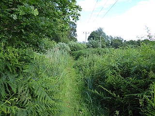
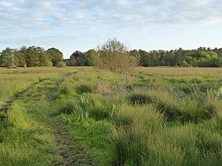
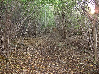
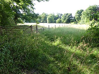
Mellis Common is a 59 hectare nature reserve in Mellis in Suffolk. It is managed by the Suffolk Wildlife Trust. [1]

Mellis village in the United Kingdom

Mellis is a small village in Suffolk, England. It has the largest area of unfenced common land in England. Oliver Cromwell exercised his troops in Mellis. It once had a railway station on the main line between London and Norwich, and a small branch line that ran to nearby Eye.

Suffolk County of England

Suffolk is an East Anglian county of historic origin in England. It has borders with Norfolk to the north, Cambridgeshire to the west and Essex to the south. The North Sea lies to the east. The county town is Ipswich; other important towns include Lowestoft, Bury St Edmunds, Newmarket and Felixstowe, one of the largest container ports in Europe.

Suffolk Wildlife Trust

Suffolk Wildlife Trust (SWT) describes itself as the county's "nature charity – the only organisation dedicated wholly to safeguarding Suffolk's wildlife and countryside." It is a registered charity, and its headquarters is at Brooke House in Ashbocking, near Ipswich. It was founded in 1961, and is one of 47 wildlife trusts covering the Great Britain and Northern Ireland. As of March 2017, it has 13,200 members, and it manages 3,120 hectares of land in 60 nature reserves, most of which are open to the public. It had an income of £3.9 million in the year to 31 March 2017.

The common has changed little over hundreds of years, and is still managed by traditional methods of grazing and hay cutting. Flora include green-winged orchid, sulphur clover and adder’s tongue fern, and owls hunt small mammals. [1]

<i>Ophioglossum vulgatum</i> species of plant

Ophioglossum vulgatum, commonly known as adder's-tongue, southern adders-tongue or adders-tongue fern, is a species of fern in the family Ophioglossaceae.

There is access from Mellis Road.

Related Research Articles

Newbourne Springs Suffolk Wildlife Trust nature reserve

Newbourne Springs is a 15.7 hectare biological Site of Special Scientific Interest in Newbourne in Suffolk. It is owned by Anglian Water and managed by the Suffolk Wildlife Trust.

Thorington village in the United Kingdom

Thorington is a village and a civil parish in the hundred of Blything, in the Suffolk Coastal District of the English county of Suffolk. It is located around 3 miles (4.8 km) south-east of the town of Halesworth, immediately south of the village of Wenhaston. The A12 main road runs through the parish to the east of the village.

Mickfield Meadow Suffolk Wildlife Trust nature reserve

Mickfield Meadow is a 1.9 hectare biological Site of Special Scientific Interest north of Mickfield in Suffolk. It is managed by the Suffolk Wildlife Trust.

Bonny Wood Suffolk Wildlife Trust nature reserve

Bonny Wood is a 20 hectare nature reserve east of Barking Tye in Suffolk. It is managed by the Suffolk Wildlife Trust. The site is part of the Barking Woods biological Site of Special Scientific Interest.

Bromeswell Green Suffolk Wildlife Trust nature reserve

Bromeswell Green is a 7.2 hectare nature reserve in Bromeswell, east of Woodbridge in Suffolk. It is managed by the Suffolk Wildlife Trust.

Captains Wood Suffolk Wildlife Trust nature reserve

Captain's Wood is a 62 hectare nature reserve in Sudbourne in Suffolk. It is owned and managed by the Suffolk Wildlife Trust.

Darsham Marshes Suffolk Wildlife Trust nature reserve

Darsham Marshes is a 20 hectare nature reserve south of Darsham in Suffolk, England. It is owned and managed by the Suffolk Wildlife Trust.

Sizewell Belts Suffolk Wildlife Trust nature reserve

Sizewell Marshes is a 105.4 hectare biological Site of Special Scientific Interest adjacent to Sizewell in Suffolk. It is in the Suffolk Coast and Heaths Area of Outstanding Natural Beauty, and is part of a 144 hectare nature reserve managed by the Suffolk Wildlife Trust as Sizewell Belts.

Snape Marshes Suffolk Wildlife Trust nature reserve

Snape Marshes is a 19.8 hectare nature reserve south-east of Snape in Suffolk. It is owned and managed by the Suffolk Wildlife Trust.

Martins Meadows Suffolk Wildlife Trust nature reserve

Monewden Meadows is a 3.7 hectare biological Site of Special Scientific Interest south-west of Monewden in Suffolk. It is a Nature Conservation Review site, Grade I, and it is managed by the Suffolk Wildlife Trust under the name Martins' Meadows.

Hen Reedbeds Suffolk Wildlife Trust nature reserve

Hen Reedbeds is a 55 hectare nature reserve near the North Sea coast of the English county of Suffolk. The reserve is located in the Blyth valley between Reydon and Blythburgh, approximately 2.5 miles (4.0 km) west of Southwold. The marshes make up part of the Suffolk Coast National Nature Reserve along with reserves at Walberswick and Dingle Marshes.

Reydon Wood Suffolk Wildlife Trust nature reserve

Reydon Wood is a 16 hectare nature reserve west of Wangford in Suffolk. It is managed by the Suffolk Wildlife Trust.

Gunton Meadow Suffolk Wildlife Trust nature reserve

Gunton Meadow is a 2 hectare nature reserve in Lowestoft in Suffolk. It is managed by the Suffolk Wildlife Trust.

Hutchisons Meadow Suffolk Wildlife Trust nature reserve

Hutchison's Meadow is a one hectare nature reserve in Melton in Suffolk. It is owned and managed by the Suffolk Wildlife Trust.

Foxburrow Farm Suffolk Wildlife Trust nature reserve

Foxburrow Farm is a 67 hectare nature reserve north of Melton in Suffolk. It is managed by the Suffolk Wildlife Trust.

Gunton Warren and Corton Woods Suffolk Wildlife Trust nature reserve

Gunton Warren and Corton Woods is a 31.9 hectare Local Nature Reserve in Lowestoft in Suffolk. The site is owned by Waveney District Council, and Gunton Warren is managed by the Suffolk Wildlife Trust while Corton Woods are managed by local volunteers of the Corton Woods Project.

Church Farm Marshes Suffolk Wildlife Trust nature reserve

Church Farm Marshes is a 56 hectare nature reserve in Thorington in Suffolk. It is managed by the Suffolk Wildlife Trust.

Lound Lakes Suffolk Wildlife Trust nature reserve

Lound Lakes is a 113 hectare nature reserve between Browston Green and Hopton in Suffolk. It is owned by Essex and Suffolk Water and managed by the Suffolk Wildlife Trust.

Thorpe Morieux Woods

Thorpe Morieux Woods is a 45.2 hectare biological Site of Special Scientific Interest north of Thorpe Morieux in Suffolk. Part of it is Bull's Wood, a nature reserve managed by the Suffolk Wildlife Trust.

Papermill Reedbed Suffolk Wildlife Trust nature reserve

Papermill Reedbed is a 6 hectare nature reserve in Bramford in Suffolk. It is owned by Blakenham Farms and managed by the Suffolk Wildlife Trust.

References

  1. 1 2 "Mellis Common". Suffolk Wildlife Trust. Retrieved 3 August 2017.

Coordinates: 52°20′N1°05′E / 52.33°N 1.08°E / 52.33; 1.08

Geographic coordinate system Coordinate system

A geographic coordinate system is a coordinate system that enables every location on Earth to be specified by a set of numbers, letters or symbols. The coordinates are often chosen such that one of the numbers represents a vertical position and two or three of the numbers represent a horizontal position; alternatively, a geographic position may be expressed in a combined three-dimensional Cartesian vector. A common choice of coordinates is latitude, longitude and elevation. To specify a location on a plane requires a map projection.