Hen Reedbeds

Last updated
Hen Reedbeds
Hen Reedbeds - geograph.org.uk - 185061.jpg
Type Nature reserve
Location Southwold, Suffolk
OS grid TM471771
Area 55 hectares
Managed by Suffolk Wildlife Trust

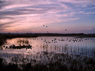
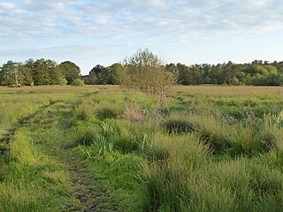
Hen Reedbeds is a 55 hectare nature reserve near the North Sea coast of the English county of Suffolk. The reserve is located in the Blyth valley between Reydon and Blythburgh, approximately 2.5 miles (4.0 km) west of Southwold. The marshes make up part of the Suffolk Coast National Nature Reserve along with reserves at Walberswick and Dingle Marshes. [1] [2]

North Sea marginal sea of the Atlantic Ocean

The North Sea is a marginal sea of the Atlantic Ocean located between the United Kingdom, Denmark, Norway, Sweden, Germany, the Netherlands, Belgium and France. An epeiric sea on the European continental shelf, it connects to the ocean through the English Channel in the south and the Norwegian Sea in the north. It is more than 970 kilometres (600 mi) long and 580 kilometres (360 mi) wide, with an area of 570,000 square kilometres (220,000 sq mi).

England Country in north-west Europe, part of the United Kingdom

England is a country that is part of the United Kingdom. It shares land borders with Wales to the west and Scotland to the north-northwest. The Irish Sea lies west of England and the Celtic Sea lies to the southwest. England is separated from continental Europe by the North Sea to the east and the English Channel to the south. The country covers five-eighths of the island of Great Britain, which lies in the North Atlantic, and includes over 100 smaller islands, such as the Isles of Scilly and the Isle of Wight.

County Geographical and administrative region in some countries

A county is a geographical region of a country used for administrative or other purposes, in certain modern nations. The term is derived from the Old French conté or cunté denoting a jurisdiction under the sovereignty of a count (earl) or a viscount. The modern French is comté, and its equivalents in other languages are contea, contado, comtat, condado, Grafschaft, graafschap, Gau, etc..

Contents

The reserve is owned by the Suffolk Wildlife Trust and is managed in conjunction with Natural England and the RSPB. [2] [3] It is part of the Minsmere-Walberswick Heaths and Marshes Site of Special Scientific Interest, as well as being a Natura 2000 site, a Ramsar Site and within the Suffolk Coast and Heaths Area of Outstanding Natural Beauty. [3] [4]

Suffolk Wildlife Trust

Suffolk Wildlife Trust (SWT) describes itself as the county's "nature charity – the only organisation dedicated wholly to safeguarding Suffolk's wildlife and countryside." It is a registered charity, and its headquarters is at Brooke House in Ashbocking, near Ipswich. It was founded in 1961, and is one of 47 wildlife trusts covering the Great Britain and Northern Ireland. As of March 2017, it has 13,200 members, and it manages 3,120 hectares of land in 60 nature reserves, most of which are open to the public. It had an income of £3.9 million in the year to 31 March 2017.

Natural England is a non-departmental public body in the United Kingdom sponsored by the Department for Environment, Food and Rural Affairs. It is responsible for ensuring that England's natural environment, including its land, flora and fauna, freshwater and marine environments, geology and soils, are protected and improved. It also has a responsibility to help people enjoy, understand and access the natural environment.

Site of Special Scientific Interest Conservation designation denoting a protected area in the United Kingdom

A Site of Special Scientific Interest (SSSI) in Great Britain or an Area of Special Scientific Interest (ASSI) in the Isle of Man and Northern Ireland is a conservation designation denoting a protected area in the United Kingdom and Isle of Man. SSSI/ASSIs are the basic building block of site-based nature conservation legislation and most other legal nature/geological conservation designations in the United Kingdom are based upon them, including national nature reserves, Ramsar sites, Special Protection Areas, and Special Areas of Conservation. The acronym "SSSI" is often pronounced "triple-S I".

The reserve was created in 1999 from an area of degraded grassland adjacent to the A1095 road. [5] [6] It was specifically created to provide a range of freshwater habitats and is an important site for bitterns and marsh harriers within the UK. [1] [3] [6]

A1095 road road in England

The A1095 road is an A road in the English county of Suffolk. It runs from Southwold on the North Sea coast to the A12 London to Great Yarmouth road at Henham between Blythburgh and Wangford. It is around 4 miles (6.4 km) in length and is single carriageway throughout. The entire length of the road lies within the Suffolk Coast and Heaths Area of Outstanding Natural Beauty.

Eurasian bittern species of bird

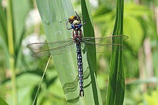
The Eurasian bittern or great bittern is a wading bird in the bittern subfamily (Botaurinae) of the heron family Ardeidae. There are two subspecies, the northern race breeding in parts of Europe and Asia, as well as on the northern coast of Africa, while the southern race is endemic to parts of southern Africa. It is a secretive bird, seldom seen in the open as it prefers to skulk in reed beds and thick vegetation near water bodies. Its presence is apparent in the spring, when the booming call of the male during the breeding season can be heard. It feeds on fish, small mammals, fledgling birds, amphibians, crustaceans and insects.

Marsh harrier

The marsh harriers are birds of prey of the harrier subfamily. They are medium-sized raptors and the largest and broadest-winged harriers. Most of them are associated with marshland and dense reedbeds. They are found almost worldwide, excluding only the Americas.

Habitats

The reserve is a mix of wetland habitats, including reedbeds, fens, dykes and pools. [1] [3] [6] It was designed to provide a breeding site for bitterns. [3] Other key species seen at the site include marsh harriers, herons, bearded tits, four-spotted chaser dragonflies and hairy dragonflies as well as mammals including otters and water voles. [1] Large roosts of starlings have been common at the reserve during autumn since 2003. [7]

Four-spotted chaser species of insect

The four-spotted chaser, known in North America as the four-spotted skimmer, is a dragonfly of the family Libellulidae found widely throughout Europe, Asia, and North America.

Hairy dragonfly species of insect

Brachytron is a monotypic genus of European dragonfly of the family Aeshnidae containing the hairy dragonfly, also known as the hairy hawker or spring hawker.

Otter subfamily of mammals

Otters are carnivorous mammals in the subfamily Lutrinae. The 13 extant otter species are all semiaquatic, aquatic or marine, with diets based on fish and invertebrates. Lutrinae is a branch of the weasel family Mustelidae, which also includes badgers, honey badgers, martens, minks, polecats, and wolverines.

The reserve is seen as an example of the effective management of habitats in the face of coastal erosion and sea level rise along the Suffolk coast. [6]

Coastal erosion The loss or displacement of land along the coastline due to the action of waves, currents, tides. wind-driven water, waterborne ice, or other impacts of storms

There are two common definitions of coastal erosion. It is often defined as the loss or displacement of land along the coastline due to the action of waves, currents, tides, wind-driven water, waterborne ice, or other impacts of storms. In this case, landward retreat of the shoreline, measured to a given spatial datum, is described over a temporal scale of tides, seasons, and other short-term cyclic processes. Alternatively, it is defined as the process of long-term removal of sediment and rocks at the coastline, leading again to loss of land and retreat of the coastline landward. Coastal erosion may be caused by hydraulic action, abrasion, impact and corrosion by wind and water, and other forces, natural or unnatural.

Sea level rise The current long-term trend for sea levels to rise mainly in response to global warming.

Since at least the start of the 20th century, the average global sea level has been rising. Between 1900 and 2016, the sea level rose by 16–21 cm (6.3–8.3 in). More precise data gathered from satellite radar measurements reveal an accelerating rise of 7.5 cm (3.0 in) from 1993 to 2017, which is a trend of roughly 30 cm (12 in) per century. This acceleration is due mostly to human-caused global warming, which is driving thermal expansion of seawater and the melting of land-based ice sheets and glaciers. Between 1993 and 2018, thermal expansion of the oceans contributed 42% to sea level rise; the melting of temperate glaciers, 21%; Greenland, 15%; and Antarctica, 8%. Climate scientists expect the rate to further accelerate during the 21st century.

Facilities

A car park is maintained at the reserve. Way marked trails, some of which are wheelchair accessible, guide visitors around the site with a range of viewing platforms and hides. [3]

Related Research Articles

Benacre National Nature Reserve

Benacre National Nature Reserve is a national nature reserve in the English county of Suffolk. It is located on the North Sea coast in the parishes of Benacre, Covehithe, Reydon and South Cove. It lies between the towns of Lowestoft and Southwold and covers 393 hectares.

Suffolk Coast and Heaths

The Suffolk Coast and Heaths AONB is an Area of Outstanding Natural Beauty in Suffolk, England.

Strumpshaw Fen RSPB reserve RSPB nature reserve in the English county of Norfolk

Strumpshaw Fen is a nature reserve managed by the Royal Society for the Protection of Birds (RSPB). It is situated at Strumpshaw on the River Yare in the English county of Norfolk around 6 miles (9.7 km) east of Norwich. The Buckenham Marshes RSPB reserve borders the reserve to the east.

RSPB Minsmere RSPB nature reserve in the United Kingdom

RSPB Minsmere is a nature reserve owned and managed by the Royal Society for the Protection of Birds (RSPB) at Minsmere, Suffolk. The 1,000-hectare (2,500-acre) site has been managed by the RSPB since 1947 and covers areas of reed bed, lowland heath, acid grassland, wet grassland, woodland and shingle vegetation. It lies within the Suffolk Coast and Heaths Area of Outstanding Natural Beauty and the Suffolk Heritage Coast area. It is conserved as a Site of Special Scientific Interest, Special Area of Conservation, Special Protection Area and Ramsar site.

Wicken Fen nature reserve in Cambridgeshire, United Kingdom

Wicken Fen is a 254.5 hectare biological Site of Special Scientific Interest west of Wicken in Cambridgeshire. It is also a National Nature Reserve, and a Nature Conservation Review site. It is protected by international designations as a Ramsar wetland site of international importance, and part of the Fenland Special Area of Conservation under the Habitats Directive.

Ham Wall Ham Wall, RSPB nature reserve, Somerset, England

Ham Wall is an English wetland National Nature Reserve (NNR) situated 4 kilometres (2.5 mi) west of Glastonbury on the Somerset Levels and managed by the Royal Society for the Protection of Birds (RSPB). Since the last Ice Age, decomposing plants in the marshes of the Brue valley in Somerset have accumulated as deep layers of peat that were commercially exploited on a large scale in the twentieth century. Consumer demand eventually reduced, and in 1994 the landowners, Fisons, gave their old workings to what is now Natural England, who passed the management of the 260 hectares Ham Wall section to the RSPB.

North Warren RSPB reserve RSPB nature reserve in the United Kingdom

North Warren RSPB reserve is a nature reserve run by the Royal Society for the Protection of Birds (RSPB) in Suffolk, England. It lies on the Suffolk coast on the north edge of the town of Aldeburgh and to the south of Thorpeness and includes the Aldringham Walks area of heathland to the north. It is within the Suffolk Coast and Heaths Area of Outstanding Natural Beauty (AONB) and the Suffolk Heritage Coast area. Noted for its populations of Eurasian bittern, European nightjar and other bird species, it covers a range of coastal habitats and is protected with SSSI, SPA conservation status.

Rosenannon Downs

Rosenannon Downs is a nature reserve in mid Cornwall, England, UK, being designated Rosenannon Bog and Downs Site of Special Scientific Interest (SSSI), noted for its biological characteristics. The site supports a wide variety of flora and fauna and includes Bronze Age barrows. Conservation work is carried out on the site by the owners, the Cornwall Wildlife Trust.

Trimley Marshes Suffolk Wildlife Trust nature reserve

Trimley Marshes is a 77 hectare nature reserve west of Trimley St Mary, on the outskirts of Felixstowe in Suffolk. It is managed by the Suffolk Wildlife Trust. It is in the Suffolk Coast and Heaths Area of Outstanding Natural Beauty, the Orwell Estuary Site of Special Scientific Interest, the Stour and Orwell Estuaries Ramsar site internationally important wetland site and Special Protection Area under the European Union Directive on the Conservation of Wild Birds.

Blaxhall Common Suffolk Wildlife Trust nature reserve

Blaxhall Common is a nature reserve in the parish of Blaxhall in the Suffolk Coastal district of Suffolk. The reserve is owned by Blaxhall Parish Council and managed by Suffolk Wildlife Trust. It is designated a 45.9 hectare biological Site of Special Scientific Interest as Blaxhall Heath. It is part of the Sandlings Special Protection Area under the European Union Directive on the Conservation of Wild Birds, and of the Suffolk Coast and Heaths Area of Outstanding Natural Beauty. A Bronze Age bowl barrow is a Scheduled Monument.

Barnby Broad and Marshes human settlement in United Kingdom

Barnby Broad and Marshes is a Site of Special Scientific Interest (SSSI) in the Waveney district of the English county of Suffolk. The site is 189.6 hectares in size. It is in the parishes of North Cove and Barnby, located between Beccles and Lowestoft in the north of the county. The site is bordered on its southern edge by the East Suffolk railway line and to the north by the River Waveney. It is a Special Area of Conservation, a Special Protection Area under the EC Birds Directive, and a Ramsar internationally important wetland site. There are two Suffolk Wildlife Trust nature reserves in the site, Castle Marshes and North Cove.

Darsham Marshes Suffolk Wildlife Trust nature reserve

Darsham Marshes is a 20 hectare nature reserve south of Darsham in Suffolk, England. It is owned and managed by the Suffolk Wildlife Trust.

Dingle Marshes Suffolk Wildlife Trust and RSPB nature reserve

Dingle Marshes is a 93 hectares wildlife reserve on the North Sea coast of the English county of Suffolk. The reserve is located between Dunwich and Walberswick, approximately 4 miles (6.4 km) south-west of Southwold. The marshes make up part of the Suffolk Coast National Nature Reserve along with reserves at Walberswick and Hen Reedbeds. They are owned jointly by the RSPB and Suffolk Wildlife Trust and are managed by these two organisations and Natural England. The site is in the Dunwich Heaths and Marshes Nature Conservation Review site, Grade I, the Minsmere-Walberswick Ramsar internationally important wetland site, the Minsmere to Walberswick Heaths and Marshes Special Area of Conservation, and the Minsmere-Walberswick Special Protection Area under the European Union Directive on the Conservation of Wild Birds.

Snape Marshes Suffolk Wildlife Trust nature reserve

Snape Marshes is a 19.8 hectare nature reserve south-east of Snape in Suffolk. It is owned and managed by the Suffolk Wildlife Trust.

Sutton and Hollesley Heaths Suffolk Wildlife Trust nature reserve

Sutton and Hollesley Heaths is a 483.3 hectare biological Site of Special Scientific Interest south-east of Woodbridge in Suffolk. Most of the site is managed by the Suffolk Wildlife Trust as Sutton and Hollesley Commons. It is part of the Sandlings Special Protection Area under the European Union Directive on the Conservation of Wild Birds, and the Suffolk Coast and Heaths Area of Outstanding Natural Beauty.

Minsmere River river in Suffolk, United Kingdom

Minsmere River is a river in the English county of Suffolk which flows into the North Sea at Minsmere. The river is formed from the River Yox at Yoxford before flowing through Middleton, Eastbridge and Minsmere. It flows to the south of Minsmere RSPB reserve helping to form many of the wetland habitats at the reserve.

Suffolk Coast National Nature Reserve

Suffolk Coast National Nature Reserve is a wildlife reserve on the North Sea coast of the English county of Suffolk. It is located around the village of Walberswick to the south of the town of Southwold. The reserve was designated in 2003, combining the existing Walberswick National Nature Reserve with reserves at Dingle Marshes and Hen Reedbeds to create a 1,340 hectares reserve.

Minsmere–Walberswick Heaths and Marshes

Minsmere–Walberswick Heaths and Marshes are a Special Area of Conservation and Site of Special Scientific Interest in the English county of Suffolk. The site is located on the North Sea coast between Southwold and Sizewell, extending over an area of coastline around 7 miles (11 km) in length. The site is also designated as a Special Protection Area, part of the Minsmere–Walberswick European Marine Site and contains areas designated as Ramsar sites and Natura 2000 sites. It lies within the Suffolk Coast and Heaths Area of Outstanding Natural Beauty and is made up of a "complex mosaic" of marshes, reed beds, shingle banks and lowland heath habitats.

References

  1. 1 2 3 4 Suffolk Coast NNR, Natural England. Retrieved 2012-10-30.
  2. 1 2 Suffolk Coast National Nature Reserve, Direct enquiries. Retrieved 2012-10-30.
  3. 1 2 3 4 5 6 Hen Reedbeds, Suffolk Wildlife Trust. Retrieved 2012-10-31.
  4. About us, Suffolk Coast and Heaths AONB. Retrieved 2014-03-08.
  5. Fitting tribute to warden of Southwold wildlife site, Lowestoft Journal, 2011-05-12. Retrieved 2014-03-08.
  6. 1 2 3 4 Suffolk's changing coast, Royal Society for the Protection of Birds. Retrieved 2012-10-31.
  7. Starlings take over at Southwold, BBC news website, 2009-11-25. Retrieved 2012-10-31.

Coordinates: 52°20′06″N1°37′30″E / 52.335°N 1.625°E / 52.335; 1.625