River Blyth, Suffolk

Last updated

Blyth
River Blyth - geograph.org.uk - 101018.jpg
The River Blyth near Wenhaston.
Suffolk UK relief location map.jpg
Red pog.svg
Location of the river mouth within Suffolk
Location
Country England
Region Suffolk
Physical characteristics
Source Laxfield
  coordinates 52°17′58″N1°20′23″E / 52.2995°N 1.3398°E / 52.2995; 1.3398
  elevation58 m (190 ft)
Mouth North Sea near Walberswick
  coordinates
52°18′48″N1°40′30″E / 52.3133°N 1.675°E / 52.3133; 1.675
  elevation
0 m (0 ft)
Length30.5 km (19.0 mi)

The River Blyth is a river in east Suffolk, England. Its source is near Laxfield [1] and it reaches a tidal estuary between Southwold and Walberswick on the North Sea coast. [2]

Contents

Course

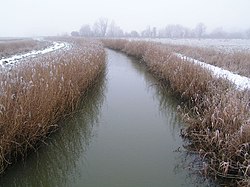
The course of the river passes through agricultural land between Laxfield and Halesworth, flowing through the estate of Heveningham Hall and the village of Walpole before being crossed by the A144 road and the East Suffolk Line to the south of Halesworth. East of Halesworth the river is canalised in places and has a clear flood plain with land being used as grazing marsh. At Blythburgh it is crossed by the A12 trunk road before entering the estuarine section of the river.

The estuary mouth forms the main harbour area of Southwold and is still an active fishing harbour. The estuary is central to the plot of Peter Greenaway's film Drowning by Numbers , being the scene of the final drowning. The river can be crossed by pedestrians by a public footbridge called the Bailey Bridge about a mile upstream from the sea or by the Walberswick rowing boat ferry.

The Blyth Navigation canal was opened in 1761 running 7 miles (11 km) from Halesworth to the Blyth estuary, leading to the canalisation of the river east of Halesworth. It was insolvent by 1884, partly due to attempts to reclaim saltings at Blythburgh, which resulted in the estuary silting up and partly due to the opening of the Southwold Railway in 1879. The navigation was used sporadically until 1911, and was not formally abandoned until 1934.

History

The river gives its name to the settlements of Blyford, indicating a formerly important ford over the river, and Blythburgh. The river's name itself comes from an Old English word blithe meaning "gentle or pleasant". [3]

Related Research Articles

<span class="mw-page-title-main">Southwold</span> Coastal resort in Suffolk, England

Southwold is a seaside town and civil parish on the North Sea, in the East Suffolk district, in the county of Suffolk, England. It lies at the mouth of the River Blyth in the Suffolk Coast and Heaths Area of Outstanding Natural Beauty, 11 miles (18 km) south of Lowestoft, 29 miles (47 km) north-east of Ipswich and 97 miles (156 km) north-east of London, within the parliamentary constituency of Suffolk Coastal. At the 2021 Census, the population was 950.

<span class="mw-page-title-main">Walberswick</span> Human settlement in England

Walberswick is a village and civil parish on the Suffolk coast in England. It is at the mouth of the River Blyth on the south side of the river. The town of Southwold lies to the north of the river and is the nearest town to Walberswick, around 1 mile (1.6 km) away. Walberswick is around 11 miles (18 km) south of Lowestoft on the North Sea coast. It is 7 miles (11 km) east of Halesworth and 28 miles (45 km) northeast of the county town of Ipswich.

<span class="mw-page-title-main">Reydon</span> Human settlement in England

Reydon is a village and civil parish, 1.0 mile (1.6 km) north-west of Southwold and 2.5 miles (4.0 km) south-east of Wangford, in the East Suffolk district and the ceremonial county of Suffolk, England. Its population of 2,567 in 2001 including Easton Bavents eased up to 2,582 at the 2011 Census, and was estimated at 2,772 in 2018. The name probably means Rye Hill, Rey meaning rye and -don being an old word for hill or rise). The village is close to the cliffs at Easton Bavents, a village now much eroded. Both were established before neighbouring Southwold. The parish church is St Margaret of Antioch. The parish of Easton Bavents was merged with Reydon in 1987, when part of Southwold was also transferred.

<span class="mw-page-title-main">Blyth Navigation</span>

The Blyth Navigation was a canal in Suffolk, England, running 7 miles (11 km) from Halesworth to the North Sea at Southwold. It opened in 1761, and was insolvent by 1884. Its demise was accelerated by an attempt to reclaim saltings at Blythburgh, which resulted in the estuary silting up. It was used sporadically until 1911, and was not formally abandoned until 1934.

<span class="mw-page-title-main">River Blackwater, Essex</span> River in Essex, England

The River Blackwater is a river in Essex, England. It rises as the River Pant in the northwest of the county, just east of Saffron Walden, and flows in a generally southeast direction to Bocking, near Braintree, via Great Sampford and Great Bardfield. At Bocking, it becomes the River Blackwater, and veers east to flow past Bradwell Juxta Coggeshall and Coggeshall. It then veers south, flowing past Kelvedon and Witham, before reaching Maldon. There, it veers east again and empties into the Blackwater Estuary, which in turn meets the North Sea at Mersea Island.

<span class="mw-page-title-main">Halesworth</span> Town and civil parish in Suffolk, England

Halesworth is a market town, civil parish and electoral ward in north-eastern Suffolk, England. The population stood at 4,726 in the 2011 Census. It lies 15 miles (24 km) south-west of Lowestoft, on a tributary of the River Blyth, nine miles upstream from Southwold. The town is served by Halesworth railway station on the Ipswich–Lowestoft East Suffolk Line. It is twinned with Bouchain in France and Eitorf in Germany. Nearby villages include Cratfield, Wissett, Chediston, Walpole, Blyford, Linstead Parva, Wenhaston, Thorington, Spexhall, Bramfield, Huntingfield, Cookley and Holton.

<span class="mw-page-title-main">Mid-Suffolk Light Railway</span> Standard gauge railway

The Mid-Suffolk Light Railway (MSLR) was a standard gauge railway intended to open up an agricultural area of central Suffolk; it took advantage of the reduced construction cost enabled by the Light Railways Act 1896. It was launched with considerable enthusiasm by local interests, and was to build a 50-mile (80 km) network, but actual share subscription was weak, and the company over-reached its available financial resources. It opened 19 miles (31 km) of route from Haughley to Laxfield in 1904 to goods traffic only, and income was poor, further worsening the company's financial situation.

<span class="mw-page-title-main">Southwold Railway</span> Disused narrow gauge railway in Suffolk

The Southwold Railway was a narrow gauge railway line between Halesworth and Southwold in the English county of Suffolk. 8 miles 63+12 chains (14.15 km) long, it was 3 ft narrow gauge. It opened in 1879 and closed in 1929.

<span class="mw-page-title-main">Blythburgh</span> Human settlement in England

Blythburgh is a village and civil parish in the East Suffolk district of the English county of Suffolk. It is 4 miles (6.4 km) west of Southwold and 5 miles (8.0 km) south-east of Halesworth and lies on the River Blyth. The A12 road runs through the village which is split either side of the road. At the 2011 census the population of the parish was 297. The parish includes the hamlets of Bulcamp and Hinton.

<span class="mw-page-title-main">River Alde</span> River system in Suffolk, England

The River Alde and River Ore form a river system in Suffolk, England passing by Snape and Aldeburgh. The River Alde and River Ore meet northwest of Blaxhall. From there downriver the combined river is known as the River Alde past Snape and Aldeburgh, and then again as the River Ore as it approaches Orford and flows by a shingle spit before emptying into the North Sea.

<span class="mw-page-title-main">Wenhaston</span> Village in Suffolk, England

Wenhaston is a village in the civil parish of Wenhaston with Mells Hamlet, in the East Suffolk district, in northeastern Suffolk, England. It is situated to the south of the River Blyth. In 2018 it had an estimated population of 563.

<span class="mw-page-title-main">A145 road</span> Road in Suffolk, England

The A145 is an A road in the English county of Suffolk. It runs from east of the town of Beccles, close to the border with Norfolk, to the village of Blythburgh where it joins the A12 road. It is around 11 miles (18 km) in length and single carriageway throughout.

The ferries in Suffolk are a series of local ferry services in the county of Suffolk in Eastern England. Most cross rivers within the county, and one connects Suffolk with Essex to the south.

<span class="mw-page-title-main">Dunwich</span> Farm village in Suffolk, England

Dunwich is a village and civil parish in Suffolk, England. It is in the Suffolk Coast and Heaths AONB around 92 miles (148 km) north-east of London, 9 miles (14 km) south of Southwold and 7 miles (11 km) north of Leiston, on the North Sea coast.

<span class="mw-page-title-main">A144 road</span> Road in Suffolk, England

The A144 is an A road in the English county of Suffolk. It runs from the town of Bungay, close to the border with Norfolk, to the A12 trunk road near the village of Darsham, passing through the market town of Halesworth. It is around 14 miles (23 km) in length and is single carriageway throughout.

<span class="mw-page-title-main">A1095 road</span> Road in Suffolk, England

The A1095 road is an A road in the English county of Suffolk. It runs from Southwold on the North Sea coast to the A12 London to Lowestoft road at Henham between Blythburgh and Wangford. It is around 4 miles (6.4 km) in length and is single carriageway throughout. The entire length of the road lies within the Suffolk Coast and Heaths Area of Outstanding Natural Beauty.

<span class="mw-page-title-main">Hen Reedbeds</span>

Hen Reedbeds is a 55 hectare nature reserve near the North Sea coast of the English county of Suffolk. The reserve is located in the Blyth valley between Reydon and Blythburgh, approximately 2.5 miles (4.0 km) west of Southwold. The marshes make up part of the Suffolk Coast National Nature Reserve along with reserves at Walberswick and Dingle Marshes.

<span class="mw-page-title-main">Blything Rural District</span>

Blything Rural District was a rural district within the administrative county of East Suffolk between 1894 and 1934.

<span class="mw-page-title-main">Wangford with Henham</span> Human settlement in England

Wangford with Henham is a civil parish in the East Suffolk district of the English county of Suffolk. It is around 5.5 miles (8.9 km) east of Halesworth, 3 miles (4.8 km) north-west of Southwold and 8.5 miles (13.7 km) south of Beccles. The parish includes the village of Wangford, the hamlet of Barnaby Green and Henham Park, the site of the Latitude Festival and a variety of other events. The Henham estate, owned by the Rous family, later the Earls of Stradbroke, owned much of the land in the parish and were responsible for many of the buildings in the area.

References

  1. "blythweb.co.uk - Source". Archived from the original on 16 April 2012. Retrieved 6 September 2012.
  2. "blythburgh.net - Tidal" . Retrieved 6 September 2012.
  3. A. D. Mills. A Dictionary of British Place Names. Oxford University Press.