River Deben

Last updated
Deben
Woodbridge Tide Mill (1).jpg
Woodbridge Tide Mill from the River Deben
Suffolk UK relief location map.jpg
Red pog.svg
Location of the river mouth within Suffolk
Location
Country England
Region Suffolk
Physical characteristics
Source Bedingfield
  coordinates 52°15′34″N1°11′14″E / 52.2594°N 1.1873°E / 52.2594; 1.1873
  elevation60 m (200 ft)
2nd source Debenham
  coordinates 52°13′35″N1°08′01″E / 52.2263°N 1.1336°E / 52.2263; 1.1336
  elevation54 m (177 ft)
Mouth North Sea near Felixstowe
  coordinates
51°58′51″N1°23′34″E / 51.9808°N 1.3927°E / 51.9808; 1.3927
  elevation
0 m (0 ft)
Length54 km (34 mi)
Basin features
Tributaries 
  right River Fynn

The River Deben is a river in Suffolk rising to the west of Debenham, though a second, higher source runs south from the parish of Bedingfield. The river passes through Woodbridge, turning into a tidal estuary before entering the North Sea at Felixstowe Ferry. The mouth of the estuary is crossed by a ferry connecting Felixstowe and Bawdsey. [1]

Contents

History

Both the river-name and the name of the village of Debenham are of uncertain origin and relationship, [2] but one theory (of several on offer) is that the river's name was originally Dēope meaning 'the deep one'. [3] The river-name, however, is not recorded in the form Deben before 1735, when it appears thus in Kirby's Suffolk Traveller. The river, though still little more than a stream, is forded twice in the village, with that which runs along Stoney Lane being claimed to be among the longest in England. [4]

Course of the River Deben

River Deben Estuary

Tide mills at Woodbridge have operated off the tide from the river Deben since at least 1170. The present mill, built in 1793, is producing stone ground wholemeal flour in the traditional way. [5] It marks the point from which the River Deben flows into the Deben Estuary. The Deben Estuary Plan was drawn up by the Deben Estuary Partnership. Following feedback to the Deben Estuarine Strategy, in 2009 the Deben Estuary Partnership has been developed to enable the local communities to have an input into complex and increasingly important issues that will be crucial for the River Deben and the surrounding estuary area. [6]


The Deben Estuary is a Special Protection Area and Ramsar Site and within the Suffolk Coast and Heaths Area of Outstanding Natural Beauty. Its significance arises from its over-wintering population of avocets (Recurvirostra avosetta). The estuary features shifting sandbanks. Plant life is dominated by the common reed (Phragmites australis). The salt marsh and intertidal mud-flats that occupy most of the area have the widest range of salt marsh flora in Suffolk.

Water resource management

Water resource management has evolved in relation to the River Deben. Since 2023 the East Suffolk Water Management Board has been responsible for this. It traces its origin to the Internal drainage boards established in 1933. The "River Deben (upper) Internal Drainage Board" and the "River Deben (lower) Internal Drainage Board' were established at this time, and were responsible water management until amalgamation in 2005. [7]

Leisure

A Martello tower and the mouth of River Deben at Felixstowe Ferry in June 2019 Cmglee Felixstowe Ferry promontory.jpg
A Martello tower and the mouth of River Deben at Felixstowe Ferry in June 2019

There are several yacht and dinghy clubs on the river Deben. These include the Deben Rowing Club, Deben Yacht Club, the Waldringfield Sailing Club, Felixstowe Ferry Sailing Club and the Woodbridge Cruising Club. There are two yacht harbours, the Tidemill Yacht Harbour, close to the Tide Mill; and the Granary Yacht Harbour, further upstream at Melton. The river Deben is a popular location for many other water sports including canoeing, wakeboarding, paddle boarding and windsurfing. The area where the river Deben enters the North Sea at Felixstowe Ferry is also a popular location for the sport of kitesurfing. Kitesurfers can usually be seen around low tide when the wind conditions are favourable, ranging from NE round to SW and depending on the direction of the tide.

Peninsula

The Deben Peninsula is a region of Suffolk, [8] made up of the area of the Coast and Heaths AONB between the River Deben to the south and the Alde and Ore Estuary in the north. [9] The area is relatively remote, [10] and noted for its stunning coastline. [11]

See also

Related Research Articles

<span class="mw-page-title-main">Woodbridge, Suffolk</span> Port town in Suffolk, England

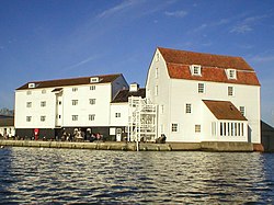
Woodbridge is a port town and civil parish in the East Suffolk district of Suffolk, England. It is 8 miles (13 km) up the River Deben from the sea. It lies 7 miles (11 km) north-east of Ipswich and around 74 miles north-east of London.

<span class="mw-page-title-main">Suffolk & Essex Coast & Heaths National Landscape</span> Area of Outstanding Natural Beauty in England

The Suffolk & Essex Coast & Heaths National Landscape is an Area of Outstanding Natural Beauty in Suffolk and Essex, England.

<span class="mw-page-title-main">River Orwell</span> River in Suffolk, England

The River Orwell flows through the county of Suffolk in England from Ipswich to Felixstowe. Above Ipswich, the river is known as the River Gipping, but its name changes to the Orwell at Stoke Bridge, where the river becomes tidal. It broadens into an estuary at Ipswich, where the Ipswich dock has operated since the 7th century, and then flows into the North Sea at Felixstowe, the UK's largest container port, after joining the River Stour at Shotley forming Harwich harbour.

<span class="mw-page-title-main">Felixstowe</span> Human settlement in England

Felixstowe is a port town in Suffolk, England. The estimated population in 2017 was 24,521. The Port of Felixstowe is the largest container port in the United Kingdom. Felixstowe is approximately 72 miles (116 km) northeast of London. Enjoy the Victorian Gardens along the sea front in a 360° virtual tour here

<span class="mw-page-title-main">Orford Ness</span> Coastal shingle spit in Suffolk, England

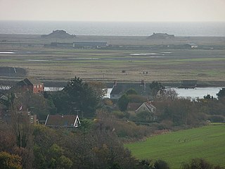
Orford Ness is a cuspate foreland shingle spit on the Suffolk coast in Great Britain, linked to the mainland at Aldeburgh and stretching along the coast to Orford and down to North Weir Point, opposite Shingle Street. It is divided from the mainland by the River Alde, and was formed by longshore drift along the coast. The material of the spit comes from places further north, such as Dunwich. Near the middle point of its length, at the foreland point or 'Ness', once stood Orfordness Lighthouse, demolished in summer 2020 owing to the encroaching sea. In the name of the lighthouse, 'Orfordness' is written as one word.

<span class="mw-page-title-main">River Alde</span> River system in Suffolk, England

The River Alde and River Ore form a river system in Suffolk, England passing by Snape and Aldeburgh. The River Alde and River Ore meet northwest of Blaxhall. From there downriver the combined river is known as the River Alde past Snape and Aldeburgh, and then again as the River Ore as it approaches Orford and flows by a shingle spit before emptying into the North Sea.

<span class="mw-page-title-main">Alderton, Suffolk</span> Human settlement in England

Alderton is a village and civil parish in the East Suffolk district of Suffolk, England, about six miles north of Felixstowe, 10 miles south-east of Woodbridge and 2 miles south of Hollesley, on the North Sea coast and in the heart of the Suffolk Coast and Heaths Area of Outstanding Natural Beauty. In 2007 its population was 430, reducing to 423 at the 2011 Census.

<span class="mw-page-title-main">Deben Estuary SSSI</span>

Deben Estuary SSSI is a 981.1-hectare (2,424-acre) biological Site of Special Scientific Interest (SSSI) covering the River Deben and its banks 12 kilometres from its mouth north of Felixstowe to Woodbridge in Suffolk. It is a Ramsar internationally important wetland site and a Special Protection Area under the European Union Directive on the Conservation of Wild Birds. It is also in the Suffolk Coast and Heaths Area of Outstanding Natural Beauty. It partly overlaps two geological SSSIs, Ferry Cliff, Sutton and Ramsholt Cliff.

<span class="mw-page-title-main">Dommoc</span>

Dommoc, a place not certainly identified but probably within the modern county of Suffolk, was the original seat of the Anglo-Saxon bishops of the Kingdom of East Anglia. It was established by Sigeberht of East Anglia for Saint Felix in c. 629–631. It remained the bishopric of all East Anglia until c. 673, when Theodore of Tarsus, Archbishop of Canterbury, divided the see and created a second bishopric at either North Elmham, Norfolk, or South Elmham, Suffolk. The see of Dommoc continued to exist until the time of the Viking Wars of the 860s, after which it lapsed.

<span class="mw-page-title-main">Felixstowe Ferry</span> Human settlement in England

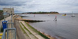
Felixstowe Ferry is a hamlet in Suffolk, England, approximately two miles northeast of Felixstowe at the mouth of the River Deben with a ferry to the Bawdsey peninsula.

Regional Cycle Route 41 in Suffolk runs from Snape to Bramfield through the Suffolk Coast and Heaths, an Area of Outstanding Natural Beauty.

The ferries in Suffolk are a series of local ferry services in the county of Suffolk in Eastern England. Most cross rivers within the county, and one connects Suffolk with Essex to the south.

<span class="mw-page-title-main">Bawdsey Manor</span>

Bawdsey Manor stands at a prominent position at the mouth of the River Deben close to the village of Bawdsey in Suffolk, England, about 75 miles (120 km) north-east of London. Built in 1886, it was enlarged in 1895 as the principal residence of Sir William Cuthbert Quilter. Requisitioned by the Devonshire Regiment during World War I and having been returned to the Quilter family after the war, it was purchased by the Air Ministry for £24,000 in 1936 to establish a new research station for developing the Chain Home RDF (radar) system. RAF Bawdsey was a base through the Cold War until the 1990s. The manor is now used by PGL for courses and children's holidays. There is a small museum in the radar transmitter block.

Colneis is a hundred of Suffolk, consisting of 16,712 acres (67.63 km2).

Wilford is a hundred of Suffolk, consisting of 31,500 acres (127 km2).

<span class="mw-page-title-main">Alde–Ore Estuary</span>

Alde–Ore Estuary is a 2,534 hectare biological and geological Site of Special Scientific Interest which stretches along the Suffolk coast between Aldeburgh and Bawdsey, and also includes parts of the Alde, Ore and Butley Rivers. It is in the Suffolk Coast and Heaths Area of Outstanding Natural Beauty, and is a Grade I Nature Conservation Review site, a Special Area of Conservation, a Ramsar internationally important wetland site, and a Special Protection Area under the European Union Directive on the Conservation of Wild Birds. It includes two Geological Conservation Review sites, "Orfordness and Shingle Street" and "The Cliff, Gedgrave", and two nature reserves managed by the Suffolk Wildlife Trust, Alde Mudflats and Simpson's Saltings. The coastal part of the site is Orfordness-Havergate, a National Nature Reserve, and Orford Ness is managed by the National Trust, while Havergate Island is managed by the Royal Society for the Protection of Birds.

The Shotley Peninsula is a rural area east of the A137 Ipswich-Colchester road located between the rivers Stour and Orwell in Suffolk, England. The peninsula is named after the settlements of Shotley and Shotley Gate which are situated near its south-eastern tip. Other villages on the peninsula include Chelmondiston, Erwarton (Arwarton), Freston, Harkstead, Holbrook, Stutton, Tattingstone, Wherstead and Woolverstone.

East Suffolk Water Management Board (ESWMB) is a water management board in East Suffolk District, Suffolk, England. It was reconstituted from the East Suffolk Internal Drainage Board on 24 March 2023.

References

  1. Ordnance Survey of Great Britain
  2. Keith Briggs and Kelly Kilpatrick. A dictionary of Suffolk place-names. English Place-Name Society.
  3. A. D. Mills. A Dictionary of British Place-Names. Oxford University Press.
  4. "Fords in Suffolk". Wet Roads. Retrieved 9 December 2013.
  5. "History". Woodbridge Tide Mill.
  6. Allam, Simon; Astley-Read, Trazar; Block, Christine; Henderson, Graham; Judge, Adrian Whittle, Peter; Read, Simon; Thomas, Karen; Thomas, Michael; Whittle, Robin; Youngs, Peter (2015). The Deben Estuary Plan April 2015 (PDF). Woodbridge: Deben Estuary Partnership.{{cite book}}: CS1 maint: multiple names: authors list (link)
  7. "Post Consultation Draft, April 2019" (PDF). Water Management Alliance. Retrieved 1 April 2024.
  8. "Shingle and Saxons: a car-free trip to the Suffolk coast". the Guardian. 2019-09-21. Retrieved 2023-01-19.
  9. "Guide to the Deben Peninsula on The Suffolk Coast". The Suffolk Coast. Retrieved 2023-01-19.
  10. Farrell, Aimee (2018-09-18). "How Margaret Howell, Master of British Fashion, Became a Beachcomber". The New York Times. ISSN   0362-4331 . Retrieved 2023-01-19.
  11. Pickup, Mike (2022-03-26). "Britain's 10 quirkiest places to stay this spring – from houseboats to horse boxes". The Telegraph. ISSN   0307-1235 . Retrieved 2023-01-19.