
The Suffolk & Essex Coast & Heaths National Landscape is an Area of Outstanding Natural Beauty in Suffolk and Essex, England.

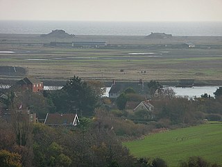
Walton-on-the-Naze is a seaside town on the North Sea coast. It is part of the parish of Frinton and Walton, in the Tendring district in Essex, England. The town is located north of Clacton and south of the port of Harwich; Frinton-on-Sea lies to the south of the town. The town has a population of 12,054, according to the 2011 census; in 1931, the parish had a population of 3,071. The town attracts many visitors; The Naze and the pier are the main attractions.

Porthleven is a town, civil parish and fishing port near Helston, Cornwall, England, United Kingdom. The most southerly port in Great Britain, it was a harbour of refuge when this part of the Cornish coastline was infamous for wrecks in the days of sail. The South West Coast Path from Somerset to Dorset passes through the town. The population at the 2011 census was 3,059.

Worth Matravers is a village and civil parish in the English county of Dorset. The village is situated on the cliffs west of Swanage. It comprises limestone cottages and farm houses and is built around a pond, which is a regular feature on postcards of the Isle of Purbeck.
Orford Ness is a cuspate foreland shingle spit on the Suffolk coast in Great Britain, linked to the mainland at Aldeburgh and stretching along the coast to Orford and down to North Weir Point, opposite Shingle Street. It is divided from the mainland by the River Alde, and was formed by longshore drift along the coast. The material of the spit comes from places further north, such as Dunwich. Near the middle point of its length, at the foreland point or 'Ness', once stood Orfordness Lighthouse, demolished in summer 2020 owing to the encroaching sea. In the name of the lighthouse, 'Orfordness' is written as one word.

Cayton is a village and civil parish in the Scarborough borough of North Yorkshire, England, 4 miles (6 km) south of Scarborough.

Deben Estuary SSSI is a 981.1-hectare (2,424-acre) biological Site of Special Scientific Interest (SSSI) covering the River Deben and its banks 12 kilometres from its mouth north of Felixstowe to Woodbridge in Suffolk. It is a Ramsar internationally important wetland site and a Special Protection Area under the European Union Directive on the Conservation of Wild Birds. It is also in the Suffolk Coast and Heaths Area of Outstanding Natural Beauty. It partly overlaps two geological SSSIs, Ferry Cliff, Sutton and Ramsholt Cliff.
The Durham Coast is a Site of Special Scientific Interest in County Durham, England. Starting just North of the River Tees estuary it extends, with a few interruptions, northward to the mouth of the River Tyne at South Shields. Notable locations on the Durham Coast include Hartlepool Headland, Seaham, Sunderland Docks and Whitburn Beach.

Harpsden is a rural and semi-rural village and civil parish immediately south of Henley-on-Thames in South Oxfordshire, Oxfordshire, England. Its scattered centre is set 0.5 miles (0.80 km) from the east border which is the River Thames, marking a short boundary with Berkshire. The parish extends 5 miles (8.0 km) inland and borders Rotherfield Peppard to the west, that is, next to its main sections of woodland in the southern extreme of the Chiltern Hills including an SSSI area of ancient woodland. The village has neither a railway station nor shops, but has the main road from Reading to Henley, both of which have grown substantially since World War II into centres of trade, education and general meeting places, such as by their increased number of cafés and restaurants.

West Thorney is a village and civil parish in the Chichester district in West Sussex, England located nine kilometres west of Chichester south of the A27 road.
Royal Air Force Bawdsey or more simply RAF Bawdsey is a former Royal Air Force station situated on the eastern coast in Suffolk, England. Also known as Bawdsey Research Station (BRS), the first Chain Home radar station was built there, characterized by eight tall masts, four for transmitting and four for receiving. When the research group moved to Dundee in September 1939, the radar station was left active under the name RAF Bawdsey. The site later hosted a Bristol Bloodhound surface-to-air missile station until 1990, with the station closing in 1991.

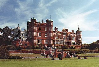
Bawdsey Manor stands at a prominent position at the mouth of the River Deben close to the village of Bawdsey in Suffolk, England, about 75 miles (120 km) north-east of London. Built in 1886, it was enlarged in 1895 as the principal residence of Sir William Cuthbert Quilter. Requisitioned by the Devonshire Regiment during World War I and having been returned to the Quilter family after the war, it was purchased by the Air Ministry for £24,000 in 1936 to establish a new research station for developing the Chain Home RDF (radar) system. RAF Bawdsey was a base through the Cold War until the 1990s. The manor is now used by PGL for courses and children's holidays. There is a small museum in the radar transmitter block.

Lilstock is a hamlet in the civil parish of Stringston in Somerset, England. It is 12 miles (19 km) north-west of Bridgwater, and 8 miles (13 km) north-east of Williton. It is on the coast of Bridgwater Bay on the Bristol Channel, near the Hinkley Point nuclear power stations.

William Alan Stewart Butement was a New Zealand-born British-Australian defence scientist and public servant. A native of New Zealand, he made extensive contributions to radar development in Great Britain during World War II, served as the first chief scientist for the Australian Defence Scientific Service, then ended his professional career with a research position in private business.

The Red Crag Formation is a geological formation in England. It outcrops in south-eastern Suffolk and north-eastern Essex. The name derives from its iron-stained reddish colour and crag which is an East Anglian word for shells. It is part of the Crag Group, a series of notably marine strata which belong to a period when Britain was connected to continental Europe by the Weald–Artois Anticline, and the area in which the Crag Group was deposited was a tidally dominated marine bay. This bay would have been subjected to enlargement and contraction brought about by transgressions and regressions driven by the 40,000-year Milankovitch cycles.

The Crouch and Roach Estuaries are a 1729 hectare biological Site of Special Scientific Interest (SSSI) at the mouth of the Crouch and Roach rivers in Essex. The Crouch part of the SSSI stretches from near Battlesbridge to Foulness Island, and the Roach from Rochford to the junction with the Crouch. Part of the site is in the Mid-Essex Coast Special Protection Area under the EC Directive on the Conservation of Wild Birds, and a Ramsar wetland site of international importance. It is also part of the Essex Estuaries Special Area of Conservation. An area of 65 hectares is managed by the Essex Wildlife Trust as the Lion Creek and Lower Raypits nature reserve and 8 hectares at Woodham Fen, both of which are managed by the Essex Wildlife Trust. A small area is also a geological SSSI, The Cliff, Burnham-on-Crouch.

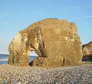
The Naze SSSI is a 22 hectare geological Site of Special Scientific Interest on The Naze peninsula north of Walton-on-the-Naze in Essex. It is a Geological Conservation Review site both for its Pleistocene fossils and for its birds. It is part of The Naze Nature Reserve, which is managed by the Essex Wildlife Trust.

Bawdsey Cliff is a 17.4-hectare (43-acre) geological Site of Special Scientific Interest north-east of Felixstowe in Suffolk. It is a Geological Conservation Review site, and is in the Suffolk Coast and Heaths Area of Outstanding Natural Beauty.


