East Suffolk District

Last updated

East Suffolk
East Suffolk District
Lowestoft beach and outer harbour.jpg
Beach and harbour at Lowestoft, the district's largest town.
East Suffolk UK locator map.svg
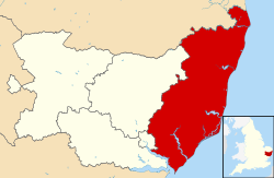
East Suffolk district within the county of Suffolk
Coordinates: 52°12′N1°30′E / 52.2°N 1.5°E / 52.2; 1.5
Sovereign state United Kingdom
Constituent country England
Region East of England
Non-metropolitan county Suffolk
Status Non-metropolitan district
Admin HQ Melton
Incorporated1 April 2019
Government
  TypeNon-metropolitan district council
  BodyEast Suffolk Council
Area
  Total200 sq mi (510 km2)
Population
 (2021)
  Total246,058
  Density1,210/sq mi (469/km2)
Ethnicity (2021)
[1]
   Ethnic groups
List
Religion (2021)
[1]
   Religion
List
Time zone UTC0 (GMT)
  Summer (DST) UTC+1 (BST)

East Suffolk is a local government district in Suffolk, England. The largest town is Lowestoft, which contains Ness Point, the easternmost point of the United Kingdom. The second largest town is Felixstowe, which has the country's largest container port. On the district's south-western edge it includes parts of the Ipswich built-up area. The rest of the district is largely rural, containing many towns and villages, including several seaside resorts. Its council is based in the village of Melton. The district was formed in 2019 as a merger of the two previous districts of Suffolk Coastal and Waveney. In 2021 it had a population of 246,058. It is the most populous district in the country not to be a unitary authority.

Contents

The district is on the coast, facing the North Sea. Much of the coast and adjoining areas lies within the Suffolk Coast and Heaths, a designated Area of Outstanding Natural Beauty. Some northern parts of the district lie within The Broads.

The neighbouring districts are Babergh, Ipswich, Mid Suffolk, South Norfolk and Great Yarmouth.

History

The district was formed on 1 April 2019 as a merger of the two previous districts of Suffolk Coastal and Waveney. [2] The two councils had previously been working in partnership since 2008. [3]

Although it has the same name, the modern district covers a smaller area than the former administrative county of East Suffolk, which was abolished in 1974 under the Local Government Act 1972.

Governance

East Suffolk Council
East Suffolk Council.svg
Type
Type
Leadership
Anthony Speca,
Green
since 24 May 2023 [4]
Caroline Topping,
Green
since 24 May 2023
Chris Bally
since 2022 [5]
Structure
Seats55 councillors
East Suffolk District Council 2023.svg
Political groups
Administration (28)
  Green (16)
  Liberal Democrats (11)
  Independent (1)
Other parties (27)
  Conservative (15)
  Labour (12)
Elections
Last election
4 May 2023
Next election
6 May 2027
Meeting place
East Suffolk House, Station Road, Melton, Woodbridge, IP12 1RT
Website
www.eastsuffolk.gov.uk

East Suffolk Council provides district-level services. County-level services are provided by Suffolk County Council. The whole district is also covered by civil parishes, which form a third tier of local government. [6] [7]

In the parts of the district within The Broads, town planning is the responsibility of the Broads Authority. The district council appoints one of its councillors to sit on that authority. [8]

Political control

The council has been under no overall control since the 2023 election, being run by a coalition of the Greens, Liberal Democrats and an independent councillor, led by Green councillor Caroline Topping. [9]

Political control of the council since 2019 has been as follows:

Party in controlYears
Conservative 2019–2023
No overall control 2023–present

Leadership

The councillors of the two previous districts formed a shadow authority in the year leading up to the council's creation in 2019. The shadow authority was led by Conservative councillor Mark Bee, leader of the outgoing Waveney District Council. He was unsuccessful in securing a seat on the new council at its first elections in May 2019. From East Suffolk Council's first meeting after coming into effect, the leaders of the council have been: [10]

CouncillorPartyFromTo
Steve Gallant Conservative 22 May 20197 May 2023
Caroline Topping Green 24 May 2023

Composition

Following the 2023 election, the composition of the council was: [11]

PartyCouncillors
Green 16
Conservative 15
Labour 12
Liberal Democrats 11
Independent 1
Total55

The next election is due in 2027.

Elections

East Suffolk comprises 55 councillors representing 26 wards, with each ward electing one, two or three councillors. Elections are held every four years. [12]

Premises

The council is based at East Suffolk House, opposite Melton railway station. [13] The building was purpose-built for the former Suffolk Coastal District Council and opened in 2016, becoming headquarters of the new East Suffolk Council following the formal merger in 2019. [14]

Towns and parishes

Beccles, one of the district's towns. St. Michael's Church, Beccles, Suffolk, South and east faces of the tower - geograph.org.uk - 219880.jpg
Beccles, one of the district's towns.
Southwold, one of the district's seaside resort towns. Southwold - geograph.org.uk - 3594916.jpg
Southwold, one of the district's seaside resort towns.
Framlingham Castle Framlingham Castle from the Air.jpg
Framlingham Castle

The whole district is divided into civil parishes. Thirteen of the parish councils have declared their parishes to be towns, allowing them to take the style "town council", being: [15]

See also

Related Research Articles

<span class="mw-page-title-main">Lowestoft</span> Town and civil parish in Suffolk, England

Lowestoft is a coastal town and civil parish in the East Suffolk district of Suffolk, England. As the most easterly UK settlement, it is 110 miles (177 km) north-east of London, 38 miles (61 km) north-east of Ipswich and 22 miles (35 km) south-east of Norwich, and the main town in its district. The estimated population in the built-up area exceeds 70,000. Its development grew with the fishing industry and as a seaside resort with wide sandy beaches. As fishing declined, oil and gas exploitation in the North Sea in the 1960s took over. While these too have declined, Lowestoft is becoming a regional centre of the renewable energy industry.

<span class="mw-page-title-main">Waveney District</span> Former non-metropolitan district in England

Waveney was a local government district in Suffolk, England, named after the River Waveney that formed its north-east border. The district council was based in Lowestoft, the major settlement in Waveney. The other towns in the district were Beccles, Bungay, Halesworth and Southwold.

<span class="mw-page-title-main">Tendring District</span> Non-metropolitan district in England

Tendring District is a local government district in north-east Essex, England. Its council is based in Clacton-on-Sea, the largest town. Other towns are Brightlingsea, Harwich, Frinton-on-Sea and Walton-on-the-Naze.

<span class="mw-page-title-main">South Norfolk</span> Non-metropolitan district in England

South Norfolk is a local government district in Norfolk, England. The largest town is Wymondham, and the district also includes the towns of Costessey, Diss, Harleston, Hingham, Loddon and Long Stratton. The council was based in Long Stratton until 2023 when it moved to the Broadland Business Park near Norwich, in the neighbouring Broadland district, as part of a shared facility with Broadland District Council. Some of the district's urban areas form part of the Norwich built-up area. The district also includes numerous villages and surrounding rural areas. Some eastern parts of the district lie within The Broads.

<span class="mw-page-title-main">Suffolk Coastal</span> Former non-metropolitan district in England

Suffolk Coastal was a local government district in Suffolk, England. Its council was based in Melton, having moved from neighbouring Woodbridge in 2017. Other towns include Felixstowe, Framlingham, Leiston, Aldeburgh, and Saxmundham.

<span class="mw-page-title-main">Mid Suffolk</span> Non-metropolitan district in England

Mid Suffolk is a local government district in Suffolk, England. The district is primarily a rural area, containing just three towns, being Stowmarket, Needham Market and Eye. Its council was based in Needham Market until 2017 when it moved to shared offices with neighbouring Babergh District Council in Ipswich, outside either district. In 2021 it had a population of 103,417.

<span class="mw-page-title-main">Babergh District</span> Non-metropolitan district in England

Babergh District is a local government district in Suffolk, England. In 2021 it had a population of 92,300. The district is primarily a rural area, containing just two towns, Sudbury and Hadleigh, which was the administrative centre until 2017 when the council moved to shared offices with neighbouring Mid Suffolk District Council in Ipswich, outside either district. The district is named after the medieval Babergh Hundred, which covered part of the area.

<span class="mw-page-title-main">East Suffolk (county)</span> Former county in eastern England

East Suffolk, along with West Suffolk, was created in 1888 as an administrative county of England. The administrative county was based on the eastern quarter sessions division of Suffolk. East Suffolk County Council's headquarters were at East Suffolk County Hall in Ipswich.

<span class="mw-page-title-main">Braintree District</span> Non-metropolitan district in England

Braintree District is a local government district in Essex, England. The district is named after the town of Braintree, where the council is based. The district also includes the towns of Halstead and Witham and surrounding rural areas.

<span class="mw-page-title-main">Borough of Great Yarmouth</span> Non-metropolitan district and borough in England

The Borough of Great Yarmouth is a local government district with borough status in Norfolk, England. It is named after its main town, Great Yarmouth, and also contains the town of Gorleston-on-Sea and a number of villages and rural areas, including part of The Broads. Other notable settlements include Caister-on-Sea, Hemsby, Hopton-on-Sea and Winterton-on-Sea.

<span class="mw-page-title-main">Suffolk Coastal (UK Parliament constituency)</span> Parliamentary constituency in the United Kingdom, 1983 onwards

Suffolk Coastal is a parliamentary constituency in the county of Suffolk, England which has been represented in the House of Commons of the UK Parliament since 2010 by Thérèse Coffey, a Conservative Member of Parliament. She served as Secretary of State for Environment, Food and Rural Affairs from October 2022 to November 2023

<span class="mw-page-title-main">Waveney (UK Parliament constituency)</span> Parliamentary constituency in the United Kingdom, 1983 onwards

Waveney is a constituency represented in the House of Commons of the UK Parliament since 2010 by Peter Aldous, a Conservative. It returns one Member of Parliament (MP) to the House of Commons of the Parliament of the United Kingdom.

<span class="mw-page-title-main">Suffolk County Council</span> Governmental body in England

Suffolk County Council is the administrative authority for the county of Suffolk, England. It is run by 75 elected county councillors representing 63 divisions. It is a member of the East of England Local Government Association.

Lowestoft was a parliamentary constituency centred on the town of Lowestoft in Suffolk. It returned one Member of Parliament (MP) to the House of Commons of the Parliament of the United Kingdom, elected by the first past the post voting system.

<span class="mw-page-title-main">Ipswich Borough Council</span> English local authority

Ipswich Borough Council is the local authority for Ipswich, a non-metropolitan district with borough status in Suffolk, England. It is the second tier of a two-tier system, fulfilling functions such as refuse collection, housing and planning, with Suffolk County Council providing county council services such as transport, education and social services.

Local elections were held in Waveney district every four years to elect councillors to Waveney District Council. In the past, one-third of councillors were elected each year, but in 2010 the council opted to change to a whole council election system. Since the last boundary changes in 2002, 48 councillors have been elected from 23 wards. The district was merged with Suffolk Coastal in April 2019 to form East Suffolk, meaning that the 2015 elections were the final Waveney elections to be held.

<span class="mw-page-title-main">Somerleyton, Ashby and Herringfleet</span> Human settlement in England

Somerleyton, Ashby and Herringfleet is a civil parish in the north of the English county of Suffolk. It is 5 miles (8.0 km) north-west of Lowestoft and the same distance south-west of Great Yarmouth and is in the East Suffolk district. The parish is made up of the villages of Somerleyton, Ashby and Herringfleet and at the 2011 United Kingdom census had a population of 427.

<span class="mw-page-title-main">West Suffolk District</span> Non-metropolitan district in England

West Suffolk District is a local government district in Suffolk, England. It was established in 2019 as a merger of the previous Forest Heath District with the Borough of St Edmundsbury. The council is based in Bury St Edmunds, the district's largest town. The district also contains the towns of Brandon, Clare, Haverhill, Mildenhall and Newmarket, along with numerous villages and surrounding rural areas. In 2021 it had a population of 180,820.

Elections of members of East Suffolk District Council in Suffolk, England are held every four years, following the merger of Waveney and Suffolk Coastal districts to form the new East Suffolk district in April 2019. 55 councillors are elected to the chamber, with 29 wards each electing either one, two or three representatives. The first elections to East Suffolk District Council were held on 2 May 2019.

References

  1. 1 2 UK Census (2021). "2021 Census Area Profile – East Suffolk Local Authority (E07000244)". Nomis. Office for National Statistics . Retrieved 5 January 2024.
  2. Ministry of Housing, Communities and Local Government (24 May 2018). "The East Suffolk (Local Government Changes) Order 2018". legislation.gov.uk. Retrieved 12 August 2018.
  3. "Suffolk now has 'largest district council in country'". BBC News. 1 April 2019. Retrieved 5 January 2024.
  4. "Council minutes, 24 May 2023". East Suffolk Council. Retrieved 5 January 2024.
  5. Hanson, Reece (8 November 2022). "East Suffolk Council's new chief executive confirmed". East Anglian Daily Times. Retrieved 5 January 2024.
  6. "Local Government Act 1972", legislation.gov.uk , The National Archives, 1972 c. 70, retrieved 31 May 2023
  7. "Election Maps". Ordnance Survey. Retrieved 21 September 2023.
  8. "Who we are". Broads Authority. Retrieved 6 December 2023.
  9. "East Suffolk to be run by Green/Lib Dem coalition". East Anglian Daily Times. 18 May 2023. Retrieved 4 January 2024.
  10. "Council minutes". East Suffolk Council. Retrieved 23 June 2022.
  11. "Local elections 2023: live council results for England". The Guardian.
  12. "The East Suffolk (Electoral Changes) Order 2018", legislation.gov.uk , The National Archives, SI 2018/1374, retrieved 5 January 2024
  13. "Headquarters". East Suffolk Council. Retrieved 5 January 2024.
  14. Bareham, Dominic (30 September 2022). "Suffolk council sells former offices for more than £5 million". East Anglian Daily Times. Retrieved 5 January 2024.
  15. "Town and parish councils". East Suffolk Council. Retrieved 5 January 2024.