| Kettleburgh | |
|---|---|
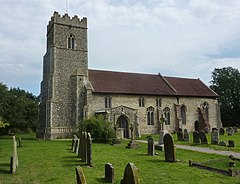 Church of St Andrew, Kettleburgh | |
 Kettleburgh Location within Suffolk | |
| Area | 5.87 km2 (2.27 sq mi) |
| Population | 231 (2011) [1] |
| • Density | 39/km2 (100/sq mi) |
| OS grid reference | TM265603 |
| District | |
| Shire county | |
| Region | |
| Country | England |
| Sovereign state | United Kingdom |
| Post town | WOODBRIDGE |
| Postcode district | IP13 |
| Dialling code | 01728 |
| Police | Suffolk |
| Fire | Suffolk |
| Ambulance | East of England |
| UK Parliament | |
Kettleburgh is a small village and civil parish in the East Suffolk district, in the county of Suffolk. The population of this Civil Parish at the 2011 Census was 231. [2]
It is near the small towns of Wickham Market and Framlingham in the valley of the River Deben. [3]
The grade I listed church of St Andrew dates from the 14th century and was restored in 1890. [4] The village also has a pub.