Beccles is a market town and civil parish in the English county of Suffolk. The town is shown on the milestone as 109 miles (175 km) from London via the A145 and A12 roads, 98 miles (158 km) north-east of London as the crow flies, 16 miles (26 km) south-east of Norwich and 33 miles (53 km) north-northeast of the county town of Ipswich. Nearby towns include Lowestoft to the east and Great Yarmouth to the north-east. The town lies on the River Waveney on the edge of The Broads National Park.

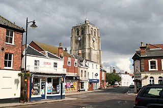
Bungay is a market town, civil parish and electoral ward in the English county of Suffolk. It lies in the Waveney valley, 5.5 miles (9 km) west of Beccles on the edge of The Broads, and at the neck of a meander of the River Waveney.

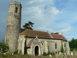
Herringfleet is a place and former civil parish in the north of the English county of Suffolk. It is located 5.5 miles (8.9 km) north-west of Lowestoft in the East Suffolk district. The parish was combined with Somerleyton and Ashby to create the parish of Somerleyton, Ashby and Herringfleet in 1987.

Homersfield, also known as St Mary, South Elmham, is a village and civil parish in the north of the English county of Suffolk. It is in the East Suffolk district, 4 miles (6.4 km) south-west of the market town of Bungay and 3 miles (4.8 km) north-east of Harleston. The official name of the civil parish is St Mary, South Elmham otherwise Homersfield. It is one of the parishes around Bungay known as The Saints.

All Saints and St Nicholas, South Elmham is a civil parish in the north of the English county of Suffolk. It is 5 miles (8.0 km) south of the market town of Bungay and the same distance north-west of Halesworth and east of Harleston. The parish is in the East Suffolk district and is one of the parishes that make up the area around Bungay known as The Saints. It includes the settlements of All Saints, South Elmham and St Nicholas, South Elmham.
Barnby is a village and civil parish in the East Suffolk district of the English county of Suffolk. The village is 5 miles (8.0 km) west of Lowestoft and 3 miles (4.8 km) east of Beccles in the north of the county. It is effectively merged with the village of North Cove which constitutes a separate parish.

Barsham is a village and civil parish in the East Suffolk district of the English county of Suffolk. It is about 2 miles (3.2 km) west of Beccles, south of the River Waveney on the edge of The Broads National Park. It is spread either side of the B1062 Beccles to Bungay road.

Blundeston is a village and civil parish in the north of the English county of Suffolk. It is 3.5 miles (5.6 km) north-west of Lowestoft, 6 miles (9.7 km) south of Great Yarmouth and around 1.75 miles (2.82 km) inland from the North Sea coast. It is part of the area known as Lothingland in the East Suffolk district. Blundeston Prison was located on the southern edge of the village but closed in early 2014.
Mutford is a village and civil parish in the East Suffolk District of the English county of Suffolk. The village is 5 miles (8.0 km) south-west of Lowestoft and 4 miles (6.4 km) south-east of Beccles in a rural area. The parish borders Barnby, Carlton Colville, Gisleham, Rushmere, Henstead with Hulver Street, Ellough and North Cove. The village gave its name to the Half Hundred of Mutford which is named in the Domesday Book.

Wissett is a village and civil parish in the English county of Suffolk. It is 2 miles (3.2 km) north-east of the market town of Halesworth in the East Suffolk district. Historically, it was in the Blything Hundred.
Ilketshall St Margaret is a village and civil parish in the north of the English county of Suffolk. It is 3 miles (4.8 km) south of the market town of Bungay in the East Suffolk district. The parish is part of the area known as the Saints and had a population of 160 at the 2011 United Kingdom census.

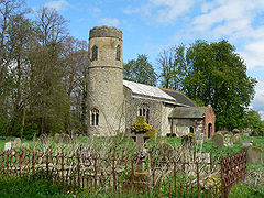
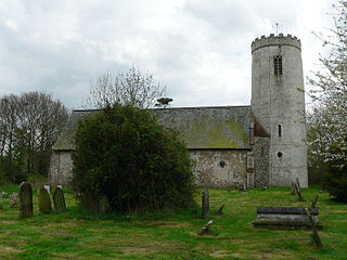
Ilketshall St Andrew is a village and civil parish in the north of the English county of Suffolk. It is 3 miles (4.8 km) south-east of Bungay and the same distance south-west of Beccles in the East Suffolk district. St Andrew's church is one of around 40 round-tower churches in Suffolk.

All Saints' South Elmham is a village and former civil parish in the north of the English county of Suffolk. The parish was combined with St Nicholas South Elmham in 1737 to form the parish of All Saints and St. Nicholas, South Elmham. It is 5 miles (8.0 km) south of the market town of Bungay in the East Suffolk district. It is one of the villages that make up the area around Bungay known as The Saints.

The A145 is an A road in the English county of Suffolk. It runs from east of the town of Beccles, close to the border with Norfolk, to the village of Blythburgh where it joins the A12 road. It is around 11 miles (18 km) in length and single carriageway throughout.

Lound is a village and civil parish in the north of the English county of Suffolk. It is 4.5 miles (7.2 km) north of Lowestoft, 5 miles (8.0 km) south of Great Yarmouth in the East Suffolk district. It is 2 miles (3.2 km) from the North Sea coast at Hopton-on-Sea and is on the border with the county of Norfolk.

Shadingfield is a village and civil parish in the East Suffolk district of the English county of Suffolk. It is located around 4 miles (6.4 km) south of Beccles in the north of the county.

Ellough is a civil parish in the East Suffolk district of the English county of Suffolk, located approximately 3 miles (5 km) south-east of Beccles. The area is sparsely populated with a mid-2005 population estimate of 40. The parish, which has an area of 4.5 square kilometres (1.7 sq mi), borders Worlingham, North Cove, Mutford, Weston, Sotterley, Willingham St Mary and Henstead with Hulver Street. The parish council operates to administer jointly the parishes of Shadingfield, Willingham St Mary, Sotterley and Ellough.

Shipmeadow is a village and civil parish located in the north of the English county of Suffolk. It is in the East Suffolk district, 2.5 miles (4.0 km) east of Bungay and the same distance west of Beccles on the B1062 road. Norwich is 15 miles (24 km) to the north-west.

The A144 is an A road in the English county of Suffolk. It runs from the town of Bungay, close to the border with Norfolk, to the A12 trunk road near the village of Darsham, passing through the market town of Halesworth. It is around 14 miles (23 km) in length and is single carriageway throughout.

North Cove is a village and civil parish in the north of the English county of Suffolk. It is part of the East Suffolk district, located around 3 miles (4.8 km) east of Beccles and 5 miles (8.0 km) west of Lowestoft. It merges with the village of Barnby and the villages share some resources, although the two parishes retain separate parish councils.