Sibton

Last updated

Sibton
Sibton Village Sign - geograph.org.uk - 1588439.jpg
Sibton village sign portrays Sibton Abbey
Suffolk UK location map.svg
Red pog.svg
Sibton
Location within Suffolk
Population182 (2011 Census)
OS grid reference TM360695
District
Shire county
Region
Country England
Sovereign state United Kingdom
Post town SAXMUNDHAM
Postcode district IP17
Dialling code 01728
Police Suffolk
Fire Suffolk
Ambulance East of England
UK Parliament
List of places
UK
England
Suffolk
52°16′23″N1°28′01″E / 52.273°N 1.467°E / 52.273; 1.467

Sibton is a village and civil parish on the A1120 road, in the East Suffolk district, in the English county of Suffolk. It is near the towns of Saxmundham and Halesworth, the village of Peasenhall and the hamlet of Sibton Green. The church is dedicated to St Peter; there is also the remains of a medieval abbey, Sibton Abbey. There is a large stately house set in the grounds of Sibton Park which dates back 1827 in the Georgian period, [1] which is now used as a hotel. The estate consists of 4500 acres, [2] being part of the Wilderness Reserve where there are holiday cottages and a lake. The Parish is also in close proximity to the River Yox which runs past the White Horse Inn and down through Pouy Street, it then goes on past both the A1120 road and a small, wooded area called Abbey Woods to pass through the grounds of Sibton Park and then on to Yoxford.

Contents

History

The name Sibton derives from Old English, where the word "Sibba" is a personal name and the word "tun" means an enclosure, a farm, village or an estate, essentially meaning "Sibba's farm or settlement". [3] Sibton was recorded in the Domesday Book of 1086 with a population of just 51 people. [4]

In the 1870s, Sibton was described as

a parish in Blything district, Suffolk; 2½ miles WNW of Yoxford r. station, and 4½ N by W of Saxmundham. Post town, Yoxford, under Saxmundham. Acres, 2,861. Real property, £4,824. Pop., 489. Houses, 101. S. Park is the seat of J. W. Brooke, Esq. [5]

Occupations

Occupations of the residents of the civil parish of Sibton, Suffolk, in 1881. The data has been taken from the 1881 census of England and Wales Occupations of the Residents of Sibton, 1881..jpg
Occupations of the residents of the civil parish of Sibton, Suffolk, in 1881. The data has been taken from the 1881 census of England and Wales

The graph shows the occupations of the citizens of Sibton in 1881 and the main occupation was in agricultural work, with 96 men and three women working in this sector. The second highest sector was in domestic service or offices. Census information from 1831 states that nearly three quarters (91 people) of Sibton's population was a labourer or a servant and 21 people were employers or professionals. [6] This is similar to the 1881 occupation statistics which showed that 99 people worked in agriculture, which is a similar figure for how many labourers there were in 1831 suggesting there was little change in these years. However, in 2011 the occupation statistics of the parish were very different, with just seven people working in agriculture. The highest sector of employment for Sibton in 2011 was people working in accommodation or food industry, with fifteen people working in this industry. [7]

Population

Total population of the parish of Sibton, Suffolk, taken from the Census of Population from 1801 to 2011. Sibton population time series 1801-2011.jpg
Total population of the parish of Sibton, Suffolk, taken from the Census of Population from 1801 to 2011.

According to the 2011 census Sibton had a population of 182- 96 of these people being male and 86 being female. [8] This is the lowest the population has been since census records began in 1801.The population hit a peak in 1821, when there were 569 people living in the parish. Since then, the population fluctuated slightly between the years of 1821 and 1841 but has continued to decrease since then. One reason for this drastic change was due to a boundary change of the parish, which was in 1885 when part of Sibton became part of Peasenhall. [9] This change was recorded in the 1891 census and meant the parish size was reduced. A continued decrease in population has also occurred as people became less dependent on farming as their main source of income and many people also moved towards the bigger towns, such as Ipswich, for work.

In 2011, 159 people living in Sibton were over the age of 16 and 23 people were under the age of 16, with the mean age being 48.6. [10] 56 people in the parish had qualifications of level 4 [11] and above.

St Peter's Church

St Peter's Church Sibton - Church of St Peter.jpg
St Peter's Church
Map of Sibton (1945) Historical map of Sibton..PNG
Map of Sibton (1945)

St Peter's Church at Sibton lies above the busy A1120 road and was founded in the reign of William II (c.1100) by Robert de Camodo. [12] The oldest part of the building is the south door, which was made in the Norman era and was originally part of Sibton Abbey. The church once had a spire which was added, along with a tower, in the 15th century. However, this spire came down about 200 years ago, although the tower still remains. After being out of use for many years the church has recently been restored, and £50,000 was raised to repair part of the roof; a further £45,000 was given by English Heritage which has helped the church regain its parish status, and regular services now take place. [13]

War Memorial

The parish's war memorial is located at the entrance to the churchyard in the form of a lychgate. Eleven men from Sibton lost their lives in the First World War; their names are carved into the memorial. Two of the men are buried in the graveyard. During the Second World War, a further two men lost their lives, and their names were added to the memorial. [14]

Notable residents

Related Research Articles

<span class="mw-page-title-main">Yoxford</span> Village in East Suffolk, England

Yoxford is a village in East Suffolk, England, close to the Heritage Coast, Minsmere Reserve (RSPB), Aldeburgh and Southwold. It is known for its antique shops and for providing the setting for a Britten opera.

<span class="mw-page-title-main">Rickinghall Inferior</span> Human settlement in England

Rickinghall Inferior is a civil parish in the Mid Suffolk district of Suffolk, England. According to the 2011 census there were 233 males and 216 females in this civil parish, for a total population of 449. It includes the western part of the village of Rickinghall and is adjacent to the village and parish of Wattisfield. The old road from the market town of Bury. St Edmunds to the City of Norwich and the town of Great Yarmouth passes through the centre of the village but the new road, the A143, uses a by-pass to the East.

<span class="mw-page-title-main">Badingham</span> Human settlement in England

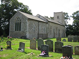
Badingham is a civil parish in the East Suffolk district of eastern England, in the county of Suffolk. It is situated 21.8 miles north east of Ipswich, 35 miles (56 km) away from Norwich and 13 miles (21 km) away from the coast. With the road "A1120" slicing through the middle of the parish. Badingham's name is Anglo-Saxon and means "the farmstead of Bada’s people". Badingham contains a significant number of farms, sparse amount of housing, numerous B&Bs as well as St. John's Church.

<span class="mw-page-title-main">Middleton, Suffolk</span> Human settlement in England

Middleton is a village in the east of the English county of Suffolk. It is located approximately 3 miles (5 km) north-west of Leiston, 5 miles (8 km) north east of Saxmundham and 3 miles (5 km) from the Suffolk coast. The village is on the B1122 around 2 miles (3 km) east of Yoxford and had a population of 359 at the 2001 census, falling to 343 at the 2011 Census.

<span class="mw-page-title-main">Knodishall</span> Village in Suffolk, England

Knodishall, a village in Suffolk, England, lies 3.5 miles (6 km) south-east of Saxmundham, 1 mile (2 km) south-west of Leiston, and 3 miles from the coast, in the Blything Hundred. Most dwellings are now at Coldfair Green; just a few remain in the original village by the parish Church of St Lawrence, which falls gently on the north side of the Hundred River valley. It is now an outlier of Knodishall Common, a settlement a mile to the south-east. The estimated parish population was 790 in 2019.
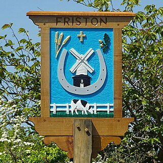
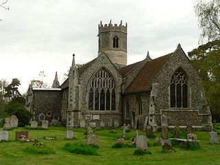
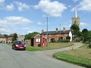
<span class="mw-page-title-main">Farnham, Suffolk</span> Human settlement in England

Farnham is a village and civil parish about 3 miles (4.8 km) south-west of Saxmundham in the English county of Suffolk on the A12 road. Farnham is located west of Friday Street, south of Benhall Low Street and north-east of Stratford St Andrew.

<span class="mw-page-title-main">A1120 road</span> Road in Suffolk, England

The A1120 is an 'A' road in the English county of Suffolk. It links Stowmarket to Yoxford passing through the centre of the county. It is 26 miles (42 km) long.

<span class="mw-page-title-main">Brent Eleigh</span> Human settlement in England

Brent Eleigh is a village and civil parish in the Babergh district of Suffolk, England. Located between Hadleigh and Lavenham, in 2005 it had a population of 180 reducing to 174 at the 2011 census.

<span class="mw-page-title-main">Brandeston</span> Village in Suffolk, England

Brandeston is a village in Suffolk, England on the River Deben 11 miles (18 km) northeast of Ipswich. Brandeston is west of Kettleburgh and northwest of Hoo Green. It is a Parish in Plomesgate district and 3½ miles SW of Framlingham r. station."

<span class="mw-page-title-main">Clopton, Suffolk</span> Human settlement in England

Clopton is a village and civil parish in Suffolk. It is located between Ipswich and Debenham two kilometres north of Grundisburgh on the River Lark. The village is no larger than a series of houses either side of the B1078, surrounded by farm land. The village itself has no clear centre; houses and other buildings are concentrated around the four manors of Kingshall, Brendhall, Rousehall and Wascolies, all of which are mentioned in the Domesday Book of 1086.

<span class="mw-page-title-main">Worlingworth</span> Village in Suffolk, England

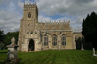
Worlingworth is a village and civil parish in the Mid Suffolk district of Suffolk in eastern England, located around ten miles south-east of Diss. In 2011 it had a total population of 802 people.

<span class="mw-page-title-main">Withersfield</span> Human settlement in England

Withersfield is a village and civil parish in the West Suffolk district of Suffolk in eastern England. In 2011 its population was 450. It has a public house and a village hall, and centres on the parish church, St. Mary the Virgin. It is in a rural location, surrounded by farmland, yet only a mile north of the busy market town of Haverhill. Surrounding villages include Great Wratting, West Wickham and Great Thurlow.

<span class="mw-page-title-main">Stansfield</span> Human settlement in England

Stansfield is a village and civil parish in the West Suffolk district of Suffolk in eastern England. Located seven miles south-west of Bury St Edmunds, in 2011 its population was 221. The village has an Anglican church dedicated to All Saints. In 1870, John Marius Wilson's Imperial Gazetteer of England and Wales described Stansfield as

<span class="mw-page-title-main">Stanfield, Norfolk</span> Human settlement in England

Stanfield is a civil parish in the English county of Norfolk. It covers an area of 3.80 km2 (1.47 sq mi) and had a population of 162 in 2011, and 144 at the 2001 census. For the purposes of local government, it falls within the district of Breckland. Stanfield belongs to the Parliamentary Constituency of Mid-Norfolk and is currently governed by George Freeman as their member of Parliament who is representative of the Conservative Party.

<span class="mw-page-title-main">Walpole, Suffolk</span> Human settlement in England

Walpole is a small village and civil parish in the district of East Suffolk in Suffolk, England. Walpole has a parish church, a redundant chapel, but the primary school has closed. The village is on the River Blyth. Nearby settlements include the town of Halesworth and the village of Cookley. It was in the hundred of Blything. It had a population of 238 according to the 2011 census.

<span class="mw-page-title-main">Rendham</span> Human settlement in England

Rendham is a village and civil parish on the B1119 road, in the East Suffolk district, in the English county of Suffolk. It is near the town Saxmundham and the village Sweffling.

<span class="mw-page-title-main">Stratford St Andrew</span> Human settlement in England

Stratford St Andrew is a small village and a civil parish just off the A12 road, in the East Suffolk district, in the English county of Suffolk. It lies 3 miles south west of Saxmundham, the nearest town.

<span class="mw-page-title-main">Peasenhall</span> Human settlement in England

Peasenhall is a village and civil parish in the East Suffolk district, in the English county of Suffolk. The population of the civil parish at the 2021 Census was 525. It lies on the A1120 tourist route; neighbouring villages include Sibton and Badingham. It was the location of the Peasenhall Murder.

Sutton is a village and a civil parish on the B1083 road, in the East Suffolk district, in the county of Suffolk, England. Sutton has a pub, a mobile post office and a place of worship. There is also the hamlet of Sutton Street and the Sutton Common estate nearby.

<span class="mw-page-title-main">Blyth Rural District</span>

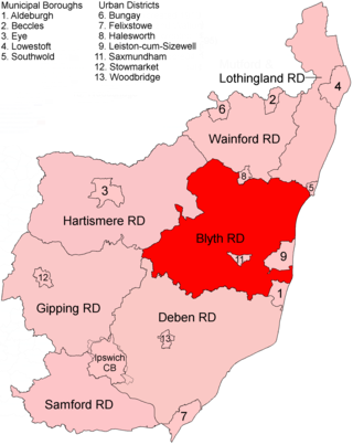
Blyth Rural District was a rural district in East Suffolk, England, between 1934 and 1974.

References

  1. "Sibton Park". thebigdomain.com. Big Domain. Retrieved 16 March 2015.
  2. "Wilderness Reserve". wildernessreserve.com. Wilderness Reserve. Retrieved 16 March 2015.
  3. The Institute for Name-Studies. "Key to English Place Names". kepn.nottingham.ac.uk. The University of Nottingham. Retrieved 23 March 2015.
  4. "Parish: Sibton" (PDF). heritage.suffolk.gov.uk. Retrieved 24 March 2015.
  5. Wilson, John Marius (1870). Gazetteer of England and Wales. Edinburgh: A. Fullarton & Co. Retrieved 27 January 2015.
  6. "Social Status, based on 1831 occupational statistics". visionofbritain.org.uk. GB Historical GIS / University of Portsmouth. Retrieved 26 March 2015.
  7. "Sibton (Parish):Industry, 2011". Neighbourhood Statistics. Office for National Statistics. Retrieved 14 April 2015.
  8. "Sibton (Parish): Key Figures for 2011 Census: Key Statistics". Neighbourhood Statistics. Office for National Statistics. Retrieved 15 April 2015.
  9. "Parish: Sibton" (PDF). heritage.suffolk.gov.uk. Retrieved 23 March 2015.
  10. "Sibton (Parish):Age Structure, 2011". Neighbourhood Statistics. Office for National Statistics. Retrieved 27 March 2015.
  11. "Sibton (Parish): Highest level of qualification". Neighbourhood Statistics. Office for National Statistics. Retrieved 15 March 2015.
  12. Moore, John. "Sibton Church" (PDF). Suffolk Churches. Retrieved 19 March 2015.
  13. Knott, Simon. "St Peter, Sibton". Suffolk Churches. Retrieved 19 March 2015.
  14. Larnder, Leslie (2006). Lest we Forget: A History of the War Memorials of Peasenhall and Sibton Suffolk. Huddersfield: Jeremy Mills Publishing. p. 47. ISBN   9781905217175 . Retrieved 23 March 2015.