
Herringfleet is a place and former civil parish in the north of the English county of Suffolk. It is located 5.5 miles (8.9 km) north-east of Lowestoft in the East Suffolk district. The parish was combined with Somerleyton and Ashby to create the parish of Somerleyton, Ashby and Herringfleet in 1987.

All Saints and St Nicholas, South Elmham is a civil parish in the north of the English county of Suffolk. It is 5 miles (8.0 km) south of the market town of Bungay and the same distance north-west of Halesworth and east of Harleston. The parish is in the East Suffolk district and is one of the parishes that make up the area around Bungay known as The Saints. It includes the settlements of All Saints, South Elmham and St Nicholas, South Elmham.

Bramfield is a village and civil parish in the east of the English county of Suffolk, and in the East Suffolk district. It is 5 miles (8.0 km) south of the market town of Halesworth on the A144 road between Halesworth and the A12 road, one of the main arterial routes through the county. The village is 24 miles (39 km) north-east of the county town of Ipswich and 15 miles (24 km) south-west of the port of Lowestoft. The East Suffolk railway line between Lowestoft and Ipswich passes close to the west of the village with Halesworth railway station being the nearest station.
Barnby is a village and civil parish in the East Suffolk district of the English county of Suffolk. The village is 5 miles (8.0 km) west of Lowestoft and 3 miles (4.8 km) east of Beccles in the north of the county. It is effectively merged with the village of North Cove which constitutes a separate parish.

Beyton is a village and civil parish in the Mid Suffolk district of the English county of Suffolk. The village is around 8 miles (13 km) east of Bury St Edmunds, 2 miles (3.2 km) south-east of Thurston and 8 miles (13 km) north-west of Stowmarket. The main Ipswich to Bury St Edmunds road used to pass through the village – the modern A14 dual carriageway bypasses the village to the north.

Blundeston is a village and civil parish in the north of the English county of Suffolk. It is 3.5 miles (5.6 km) north-west of Lowestoft, 6 miles (9.7 km) south of Great Yarmouth and around 1.75 miles (2.82 km) inland from the North Sea coast. It is part of the area known as Lothingland in the East Suffolk district. Blundeston Prison was located on the southern edge of the village but closed in early 2014.
Mutford is a village and civil parish in the East Suffolk District of the English county of Suffolk. The village is 5 miles (8.0 km) south-west of Lowestoft and 4 miles (6.4 km) south-east of Beccles in a rural area. The parish borders Barnby, Carlton Colville, Gisleham, Rushmere, Henstead with Hulver Street, Ellough and North Cove. The village gave its name to the Half Hundred of Mutford which is named in the Domesday Book.

Gisleham is a village and civil parish in the English county of Suffolk. It is on the edge of Lowestoft, around 4.5 miles (7.2 km) south-west of the town centre. The parish is in the East Suffolk district, situated between Carlton Colville and Kessingland.

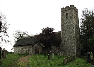
Wissett is a village and civil parish in the English county of Suffolk. It is 2 miles (3.2 km) north-east of the market town of Halesworth in the East Suffolk district. Historically, it was in the Blything Hundred.

Sotterley, originally Southern-lea from its situation south of the river, is a village and civil parish in the East Suffolk district, in the English county of Suffolk, located approximately 4 miles (6 km) south-east of Beccles and 1.5 miles (2 km) east of Willingham St Mary and Shadingfield. The parish is primarily agricultural with a dispersed population of 113 at the 2011 census. The parish council operates to administer jointly the parishes of Shadingfield, Willingham St Mary, Sotterley and Ellough.

All Saints' South Elmham is a village and former civil parish in the north of the English county of Suffolk. The parish was combined with St Nicholas South Elmham in 1737 to form the parish of All Saints and St. Nicholas, South Elmham. It is 5 miles (8.0 km) south of the market town of Bungay in the East Suffolk district. It is one of the villages that make up the area around Bungay known as The Saints.

Ixworth Thorpe is a small village and civil parish in the West Suffolk district of the English county of Suffolk. The village is located on the A1088 road around 2 miles (3.2 km) north-west of the larger village of Ixworth and 7 miles (11.3 km) north-east of Bury St Edmunds. In 2005 its estimated population was 60. The parish council is operated jointly with Ixworth. From the 2011 Census the population of the village was not recorded separately.

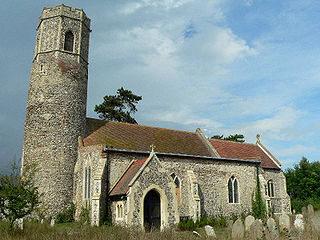
Rumburgh is a village and civil parish in the English county of Suffolk. It is 3.5 miles (5.6 km) north-east of the market town of Halesworth in the East Suffolk District. The population of the parish at the 2011 United Kingdom census was 327.
Mutford and Lothingland was a hundred of Suffolk, with an area of 33,368 acres (135.04 km2). Lowestoft Ness, the most easterly point of Great Britain fell within its bounds.

Stanningfield is a village and former civil parish, since 1988 in the parish of Bradfield Combust with Stanningfield, in the West Suffolk district of the county of Suffolk, England. The village lies just off of the A134 road, about 5 miles (8 km) south-east of Bury St Edmunds, 5 miles/8 km north-west of Lavenham, and 10 miles/16 km north of Sudbury.

North Cove is a village and civil parish in the north of the English county of Suffolk. It is part of the East Suffolk district, located around 3 miles (4.8 km) east of Beccles and 5 miles (8.0 km) west of Lowestoft. It merges with the village of Barnby and the villages share some resources, although the two parishes retain separate parish councils.

Flixton is a civil parish in the north of the English county of Suffolk. It is 2 miles (3.2 km) north-east of Lowestoft in the East Suffolk district.

Ilketshall St Lawrence is a village and civil parish in the East Suffolk district of the English county of Suffolk. It is 3 miles (4.8 km) south-east of the market town of Bungay and is part of a group of parishes with similar names known collectively as the Saints.

St Peter South Elmham is a village and civil parish in the north of the English county of Suffolk. It is around 3 miles (4.8 km) south of the market town of Bungay in the East Suffolk district. It is one of the villages surrounding Bungay which make up the area known as The Saints.

Henstead with Hulver Street is a civil parish in the East Suffolk district of the English county of Suffolk. It is around 5 miles (8.0 km) south-west of Lowestoft, 5 miles (8.0 km) south-east of Beccles and 6 miles (9.7 km) north of the coastal town of Southwold. The parish has an area of 8 square kilometres (3.1 sq mi) and consists of the villages of Henstead, where the parish church is located, and Hulver Street. It borders the parishes of Benacre, Ellough, Gisleham, Kessingland, Mutford, Rushmere, Sotterley and Wrentham.

