Kessingland is a village and civil parish in the East Suffolk district of the English county of Suffolk. It is located around 4 miles (6 km) south of Lowestoft on the east coast of the United Kingdom. It is of interest to archaeologists as Palaeolithic and Neolithic implements have been found here; the remains of an ancient forest lie buried on the seabed.

Honington is a village and civil parish located in Bardwell Ward and Pakenham and Troston Wards of West Suffolk District Council, Suffolk in eastern England It is near to the border with Norfolk. It lies on the River Black Bourn, about 8 miles (13 km) from Bury St Edmunds and 6 miles (10 km) from Thetford, Norfolk. Much of the farmland belongs to the estate of the Duke of Grafton. The village is known for its RAF station, RAF Honington. It is also near two joint RAF/USAF airfields: RAF Lakenheath and RAF Mildenhall. Honington was the birthplace of the poet Robert Bloomfield. In 2011 the parish had a population of 1472.

Henbury is a suburb of Bristol, England, approximately 5 miles (8.0 km) north west of the city centre. It was formerly a village in Gloucestershire and is now bordered by Westbury-on-Trym to the south; Brentry to the east and the Blaise Castle Estate, Blaise Hamlet and Lawrence Weston to the west. To the north lie the South Gloucestershire village of Hallen and the entertainment/retail park Cribbs Causeway.

Wrentham is a village and civil parish in the East Suffolk district, in the north-east of the English county of Suffolk. It is located about 2 miles (3.2 km) from the North Sea coast on the A12 trunk road, about 7 miles (11 km) south-west of Lowestoft, 4 miles (6.4 km) north of Southwold and 6 miles (9.7 km) south-east of Beccles.

Orford is a village in Suffolk, England, within the Suffolk Coast and Heaths Area of Outstanding Natural Beauty. It is 9 miles (14 km) east of Woodbridge.

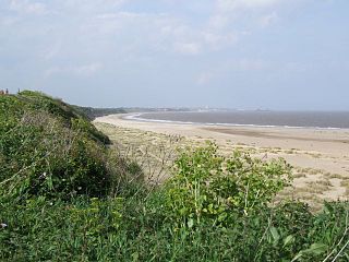
Corton is a village and civil parish in the north of the English county of Suffolk. It is 3 miles (4.8 km) north of the centre of Lowestoft in the East Suffolk district. The village is on the North Sea coast with the county border with Norfolk to the north.

Alderton is a village and civil parish in the East Suffolk district of Suffolk, England, about six miles north of Felixstowe, 10 miles south-east of Woodbridge and 2 miles south of Hollesley, on the North Sea coast and in the heart of the Suffolk Coast and Heaths Area of Outstanding Natural Beauty. In 2007 its population was 430, reducing to 423 at the 2011 Census.

Blundeston is a village and civil parish in the north of the English county of Suffolk. It is 3.5 miles (5.6 km) north-west of Lowestoft, 6 miles (9.7 km) south of Great Yarmouth and around 1.75 miles (2.82 km) inland from the North Sea coast. It is part of the area known as Lothingland in the East Suffolk district. Blundeston Prison was located on the southern edge of the village but closed in early 2014.

Boyton is a village and civil parish in the East Suffolk district of Suffolk, England, about eight miles east of Woodbridge, and close to Orford Ness. Boyton is a small village in South East England and is part of the heritage coast. In the Domesday Book of 1086 Boyton was recorded under the name "Bohtuna". The village has a number of facilities within the surrounding area, for instance Hollesley primary school, a village primary school for children aged 4–11 years. Boyton village hall is becoming a focus for new village activities, and HM Prison Hollesley Bay is also located not far from the village centre. In the 1870s Boyton was described by John Marius Wilson as:

Nacton is a village and civil parish in the East Suffolk district of Suffolk, England. The parish is bounded by the neighbouring parishes of Levington to the east and Bucklesham in the north. It is located between the towns of Ipswich and Felixstowe.

Holbrook is a village situated close to the northern shore of the estuary of the River Stour, in Suffolk, England. It is located on the Shotley Peninsula in Babergh district, around 5 miles (8 km) south of the centre of Ipswich.
HM Prison Hollesley Bay, known locally as Hollesley Bay Colony or simply The Colony, is a Category D men's prison and Young Offender Institution, located in the village of Hollesley, about 8 miles (13 km) from the town of Woodbridge in Suffolk, England. The prison is operated by His Majesty's Prison Service.
Roydon is a small village, civil parish and electoral ward east of King's Lynn in the English county of Norfolk. It covers an area of 4.62 km2 (1.78 sq mi) and had a population of 368 in 144 households at the 2001 census, the population of the village and ward being shown as 357 at the 2011 Census. For the purposes of local government, it falls within the district of King's Lynn and West Norfolk.

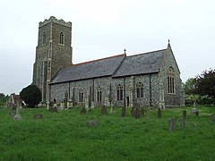
Ringsfield is a village and civil parish in the English county of Suffolk. It is 2 miles (3.2 km) south-west of Beccles in the East Suffolk district.

Shottisham is a village and civil parish in the East Suffolk district, in the county of Suffolk. It lies in the Wilford Hundred, about four and a half miles south-east of Woodbridge, between the parishes of Sutton, Alderton, Ramsholt and Hollesley, in the Bawdsey peninsula. About three miles from the coast at Hollesley Bay and Shingle Street, the village street overlooks a slight hollow of meads and copses at the road crossing of Shottisham Creek, a tributary brook of the river Deben.

Eyke is a village and a civil parish in the East Suffolk district, in the English county of Suffolk. It is located on the A1152 road near the town of Woodbridge. Eyke has a primary school, the manor house of Lord and Lady Lucas with scenic pond and horse paddock, and a pub. The mediaeval parish church of All Saints was restored in the 1860s. Services are normally held on the first and third Sundays of the month.

Hemley is a village and a civil parish in the East Suffolk district, in the county of Suffolk, England.
Chediston is a village and a civil parish on the B1123 road, in the East Suffolk district, in the English county of Suffolk. It is located 2 miles west of Halesworth, its post town. The population of the civil parish as of the 2011 census was 195 and in 2018 it was estimated to be 234.
Sutton is a village and a civil parish on the B1083 road, in the East Suffolk district, in the county of Suffolk, England. Sutton has a pub, a mobile post office and a place of worship. There is also the hamlet of Sutton Street and the Sutton Common estate nearby.

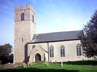
St Cross South Elmham is a village and civil parish in the north of the English county of Suffolk. It is in the East Suffolk district, close to the border with Norfolk and is 3 miles (4.8 km) east of Harleston and 4.25 miles (6.84 km) south-west of Bungay. It is one of the villages around Bungay known as the Saints.