Huntingfield, Suffolk

Last updated

Huntingfield
Huntingfield - Church of St Mary.jpg
Suffolk UK location map.svg
Red pog.svg
Huntingfield
Location within Suffolk
Area8.71 km2 (3.36 sq mi)
Population188 (2011)
  Density 22/km2 (57/sq mi)
District
Shire county
Region
Country England
Sovereign state United Kingdom
Post town Halesworth
Postcode district IP19
Police Suffolk
Fire Suffolk
Ambulance East of England
UK Parliament
List of places
UK
England
Suffolk
52°19′01″N1°25′37″E / 52.317°N 1.427°E / 52.317; 1.427
Huntingfield distinctive village sign was designed by a local resident in 2005. Huntingfield Village Sign - geograph.org.uk - 1239637.jpg
Huntingfield distinctive village sign was designed by a local resident in 2005.

Huntingfield is a village near the B1117 road, in the East Suffolk district, in the county of Suffolk, England. The village is close to the source of the River Blyth and the parish is 12 miles from the seaside town of Southwold. Nearby settlements include the town of Halesworth and the villages of Walpole, Heveningham, Cookley and Laxfield.

Contents

History

In 1870–72 John Marius Wilson described Huntingfield as,

"a village and a parish in Blything district, Suffolk. The village stands 4½ miles SW of Halesworth r. station. The parish comprises 2,134 acres; and its post town is Halesworth". [1]

Huntingfield was listed in the Domesday Book in the Hundred of Blything. The parish was written in the Domesday Book as Huntingafelda. [2]

Data from the first UK census in 1801 is available for the parish of Huntingfield. In 1801 it was recorded the population of Huntingfield was 373. The highest population was recorded in 1851,with a population of 411. However, since then, the population has slowly declined. The census data showed the population in 2011 in Huntingfield was 188. [3] This data is shown in the graph below and shows the total population of Huntingfield from 1801–2011.

Housing records for Huntingfield from 1831 to 1961 show the number of houses vacant and occupied during this time. The number of vacant houses in Huntingfield went from zero to five, with the highest number of houses occupied in 1851. [4]

Total population of Huntingfield, as reported by the census of population from 1801-2011 Population of Huntingfield.jpg
Total population of Huntingfield, as reported by the census of population from 1801–2011

In 2005, a sign was designed by a local resident, David Gentleman. The sign stands on the village green and is a distinctive feature of the village. [5]

Present Day

Nowadays Huntingfield has remained a rural parish and covers a large area that is sparsely populated. The area is mainly agricultural and is dotted with farmhouses and dwellings. [6]

The 2011 census showed the population of Huntingfield ranged from 0–93 years of age. The most common age within the village in 2011 was 56. Huntingfield is also home to young people and families. In 2011, 39 people under the age of 18 were shown to be living within the parish. [7]

The 2011 census shows Huntingfield doesn't have much cultural diversity as 108 out of its 188 population are of a Christian background. One person is of a Jewish religion while 79 people within the parish have non-or not stated their religion. [8]

The healthcare in the area of Huntingfield appears to be prominently good with 48.4% of the population having very good health compared to 2.2% of the population having bad to very bad health. [9]

Places of interest

Church of St Mary

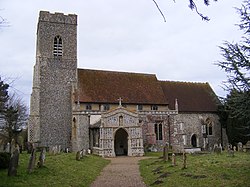
The church of St Mary is a fine example of East Anglian late Medieval work. The church is a Grade 1 listed building and dates from around the 11th century. The church often attracts visitors due to the beautifully painted ceiling. The ceiling was painted by Mildred Holland, the wife of William Holland who was the rector of the parish for 44 years through the years 1848–1892. Holland painted the Chancel roof in the style of the 15th century and during her work, the church was closed for eight months from September 1859 to April 1860. Three years later, Mildred painted the nave and other furnishings of the church. Some of the more recent painted furnishings are as a tribute to her. [10]

Huntingfield Arms

The Huntingfield arms, previously known as the Arms Inn, is listed as a grade II building. It has been part of the village since the late 18th century. [11]

The Hub

The Hub, located across the green from the Arms, is a modern example of a village hall, built in 2015/16 to serve the three villages of Huntingfield, Heveningham and Ubbeston. [12]

Transport

The parish of Huntingfield can be found on Vision of Britain. This extract is from the 1945 Ordnance Survey. 20th Century map of Huntingfield.PNG
The parish of Huntingfield can be found on Vision of Britain. This extract is from the 1945 Ordnance Survey.

Car ownership within the parish is quite high, as the 2011 census showed there are currently 130 cars registered to households in the area. [13]

Huntingfield has very limited transport facilities. The nearest railway station is in Halesworth, about 4 miles away from the parish. Bus services are also very limited. The nearest bus stop is 4 miles away (6 km). [14] This is evident as the census from 2011 showed the most common mode of transport to work was by car or a van. [15] 53 people were listed as driving a car to work, while 6 were listed as being a passenger in a car or a van. The remaining population travelled to work on a bike/moped or on foot, with only one person using a train. A high proportion, 21 people, are remote workers, while 44 people are not in employment. [16]

Economy

The occupational structure of Huntingfield as shown by the 1881 Census The occupational structure of Huntingfield as shown by the 1881 Census.jpg
The occupational structure of Huntingfield as shown by the 1881 Census

Historically, employment in Huntingfield appears to have been firmly based within the agricultural sector. The 1881 census also revealed a large majority of women were of unknown occupation. [17] The bar chart shows the types of occupations of the population of Huntingfield and the number of men and women employed in each sector. Despite agriculture being the dominant sector of employment, a large majority, particularly women were employed in Domestic services. This type of occupation included employment as a gardener, indoor servant or washing and bathing services. [18]

According to the 2011 census the agricultural sector still remains popular in the parish. Out of the 88 people of working age in Huntingfield (those aged 16–74 in employment), 12.5% are working in the agricultural area. [19] This is evident, as even today in relation to the map representing the area of Huntingfield the majority of land is agricultural, and of green space. The parish is sited on the eastern edge of the high Suffolk claylands, where the heavy soils make it ideal for farming. [20]

Despite a variety of employment shown in the graph, it appears the majority of the population in Huntingfield relied heavily on agriculture as a source of income during this time. [21]

The current average house price in Huntingfield is £515,750. In the last 12 months house prices have decreased by an average of £8,244. [22] In terms of types of housing within the parish, it is evident from the Office for National Statistics 2011 census report that the most predominant type of housing in Huntingfield is detached houses. The data also shows in 2011 there were 2 temporary structures/ caravans in the parish. [23]

Related Research Articles

<span class="mw-page-title-main">Cratfield</span> Human settlement in England

Cratfield is a village in northern Suffolk, England. "It has a population of 292 according to the 2011 census." Neighbouring villages include Laxfield, Metfield, Cookley, Huntingfield, Heveningham. The nearest town, Halesworth, is approximately 6.7 miles (10.7 km) away. Southwold is a popular, nearby coastal town. The market town of Framlingham is also close by.

<span class="mw-page-title-main">Easton, Cambridgeshire</span> Human settlement in England

Easton is a village and civil parish in Cambridgeshire, England. Easton lies approximately 6 miles (10 km) west of Huntingdon, between the villages of Ellington and Spaldwick. Easton is situated within Huntingdonshire which is a non-metropolitan district of Cambridgeshire as well as being a historic county of England. Easton is a hamlet which the Anglo Saxons settled in.

<span class="mw-page-title-main">Rickinghall Inferior</span> Human settlement in England

Rickinghall Inferior is a civil parish in the Mid Suffolk district of Suffolk, England. According to the 2011 census there were 233 males and 216 females in this civil parish, for a total population of 449. It includes the western part of the village of Rickinghall and is adjacent to the village and parish of Wattisfield. The old road from the market town of Bury. St Edmunds to the City of Norwich and the town of Great Yarmouth passes through the centre of the village but the new road, the A143, uses a by-pass to the East.

<span class="mw-page-title-main">Parham, Suffolk</span> Village and civil parish in Suffolk, England

Parham is a village and civil parish in the East Suffolk district of Suffolk in eastern England. Located seven miles north of Woodbridge, in 2005 it had a population of 300, reducing to 263 at the 2011 census and according to the 2011 census there were 129 males and 134 females living at this time.

<span class="mw-page-title-main">Bransford</span> Human settlement in England

Bransford is a village and civil parish in the Malvern Hills district of the county of Worcestershire, England. It is situated close to the River Teme and the village of Leigh. It is on the primary route between Worcester and Hereford, the A4103 that runs through the centre of the village. According to the 2021 census, Bransford has a population of 527. The parish shares its parish council with Leigh.

<span class="mw-page-title-main">Heveningham</span> Village in Suffolk, England

Heveningham is a village and civil parish in the East Suffolk district of Suffolk in eastern England. Located four miles south-west of Halesworth, in 2005 it had a population of 120.

<span class="mw-page-title-main">Clopton, Suffolk</span> Human settlement in England

Clopton is a village and civil parish in Suffolk. It is located between Ipswich and Debenham two kilometres north of Grundisburgh on the River Lark. The village is no larger than a series of houses either side of the B1078, surrounded by farm land. The village itself has no clear centre; houses and other buildings are concentrated around the four manors of Kingshall, Brendhall, Rousehall and Wascolies, all of which are mentioned in the Domesday Book of 1086.

<span class="mw-page-title-main">Flowton</span> Village and civil parish in Suffolk, England

Flowton is a village and civil parish in the Mid Suffolk district of Suffolk in eastern England, with a population of 117 people. The name 'Flowton' originally derives from the word 'Flocctun', meaning a flock of sheep or a sheep farm. The parish is located around six miles north west of Ipswich, which is the county town of Suffolk. Flowton contains the hamlet of Flowton Brook, and consists of rural farmland accompanied by scattered farm houses and a few newer builds situated nearby the parish church of 'St Mary's'. In the 1870s, Flowton was described as:

<span class="mw-page-title-main">Fakenham Magna</span> Human settlement in England

Fakenham Magna is a village and civil parish in the West Suffolk district of Suffolk in eastern England. The meaning of the word 'Fakenham' can be split into two: 'Faken' and 'ham', both of which derive from Old English. The former refers to somebody by the name of 'Facca', with the latter meaning 'a village / a homestead', making the direct translation 'Facca's homestead'. 'Magna' translates from Latin as 'great', hence the alternative name of the village of 'Great Fakenham'. During World War Two, however, the village was referred to as 'Little Fakenham', which was used to avoid confusion with the larger civil parish of Fakenham in Norfolk.

<span class="mw-page-title-main">Stansfield</span> Human settlement in England

Stansfield is a village and civil parish in the West Suffolk district of Suffolk in eastern England. Located seven miles south-west of Bury St Edmunds, in 2011 its population was 221. The village has an Anglican church dedicated to All Saints. In 1870, John Marius Wilson's Imperial Gazetteer of England and Wales described Stansfield as

<span class="mw-page-title-main">Tugby and Keythorpe</span> Human settlement in England

Tugby and Keythorpe is a civil parish comprising the village of Tugby and land surrounding Keythorpe Hall, Hall Farm and Lodge Farm in Leicestershire, England, part of the Harborough district. The Parish covers around 2,200 acres, situated 7 miles west of Uppingham, and 12 miles east of Leicester. According to the 2011 census the population of the parish was 330. The Anglican parish register for the parish dates back to 1568. The boundaries of the parish have not changed throughout the years, meaning that the parish's size remains the same as it did in 1568.

<span class="mw-page-title-main">Rochford, Worcestershire</span> Human settlement in England

Rochford consists of two hamlets, Lower and Upper Rochford. A civil parish in the Malvern Hills District near Tenbury Wells, in the county of Worcestershire, England, Rochford is 18 miles (29 km) NW of Worcester. The River Teme, which rises in Wales, flows past Lower Rochford and joins the River Severn in Worcester. The chapelry of Rochford was an exclave of Herefordshire, part of the hundred of Wolphy. It was transferred by the Counties Act 1844 to Worcestershire.

<span class="mw-page-title-main">Stanfield, Norfolk</span> Human settlement in England

Stanfield is a civil parish in the English county of Norfolk. It covers an area of 3.80 km2 (1.47 sq mi) and had a population of 162 in 2011, and 144 at the 2001 census. For the purposes of local government, it falls within the district of Breckland. Stanfield belongs to the Parliamentary Constituency of Mid-Norfolk and is currently governed by George Freeman as their member of Parliament who is representative of the Conservative Party.

<span class="mw-page-title-main">Long Marton</span> Human settlement in England

Long Marton is a village and civil parish in the Eden District of the English county of Cumbria. In 2011 the population was 827.

<span class="mw-page-title-main">Lamarsh</span> Human settlement in England

Lamarsh is a village and a civil parish in the Braintree District, in the county of Essex, England. It is near the large village of Bures and the village of Alphamstone. The village is west of the River Stour. It has a pub, a village hall and a church called The Friends of Holy Innocents Church. The civil parish's name, Lamarsh, comes from the phrase "Loamy marsh". This is derived from the Old English terms lām and mersc, which translate into loam or clay and a marsh respectively.

<span class="mw-page-title-main">Walpole, Suffolk</span> Human settlement in England

Walpole is a small village and civil parish in the district of East Suffolk in Suffolk, England. Walpole has a parish church, a redundant chapel, but the primary school has closed. The village is on the River Blyth. Nearby settlements include the town of Halesworth and the village of Cookley. It was in the hundred of Blything. It had a population of 238 according to the 2011 census.

<span class="mw-page-title-main">Pettistree</span> Human settlement in England

Pettistree is a small village and a civil parish in the East Suffolk district, in the English county of Suffolk. According to the 2011 Census, Pettistree had a population of 194 people and is set in around 1,800 acres of farmland. The village has many footpaths and country lanes surrounding it. Being only one mile from the larger village of Wickham Market, Pettistree uses many of their resources; such as the Post Office, Medical and Resource Centre and Children's Play Area. The Primary School situated in Wickham Market also serves the younger children of Pettistree. However, senior children are required to travel 7 miles to Thomas Mills High School which is situated in Framlingham.

<span class="mw-page-title-main">Eyke</span> Human settlement in England

Eyke is a village and a civil parish in the East Suffolk district, in the English county of Suffolk. It is located on the A1152 road near the town of Woodbridge. Eyke has a primary school, the manor house of Lord and Lady Lucas with scenic pond and horse paddock, and a pub. The mediaeval parish church of All Saints was restored in the 1860s. Services are normally held on the first and third Sundays of the month.

<span class="mw-page-title-main">Sibton</span> Human settlement in England

Sibton is a village and civil parish on the A1120 road, in the East Suffolk district, in the English county of Suffolk. It is near the towns of Saxmundham and Halesworth, the village of Peasenhall and the hamlet of Sibton Green. The church is dedicated to St Peter; there is also the remains of a medieval abbey, Sibton Abbey. There is a large stately house set in the grounds of Sibton Park which dates back 1827 in the Georgian period, which is now used as a hotel. The estate consists of 4500 acres, being part of the Wilderness Reserve where there are holiday cottages and a lake. The Parish is also in close proximity to the River Yox which runs past the White Horse Inn and down through Pouy Street, it then goes on past both the A1120 road and a small wooded area called Abbey Woods to pass through the grounds of Sibton Park and then on to Yoxford.

<span class="mw-page-title-main">Stapleford, Hertfordshire</span> Human settlement in England

Not to be confused with Stapleford, Nottinghamshire.

References

  1. Wilson, John Marius. Imperial Gazetteer of England and Wales. Edinburgh: A. Fullerton & Co.
  2. Powell-Smith, Anna. "Huntingfield | Domesday Book". opendomesday.org. Retrieved 12 March 2016.
  3. "Huntingfield (Parish)". Neighbourhood statistics. Office for national statistics. 2001. Retrieved 28 January 2016.
  4. "GB Historical GIS / University of Portsmouth, Huntingfield AP/CP through time Housing Statistics House Occupancy, A Vision of Britain through Time" . Retrieved 18 April 2016.
  5. "About Huntingfield | Huntingfield.Org". www.huntingfield.org. Retrieved 11 March 2016.
  6. "About Huntingfield | Huntingfield.Org". www.huntingfield.org. Retrieved 11 March 2016.
  7. "Age by single year: Neighbourhood statistics". Neighbourhood Statistics. Office for National Statistics. 2001. Retrieved 18 April 2016.
  8. "Religion: Neighbourhood Statistics". Neighbourhood Statistics. Office for National Statistics. 2001. Retrieved 18 April 2016.
  9. "Neighbourhood Statistics Health". Neighbourhood Statistics. Office for National Statistics. 2001. Retrieved 18 April 2016.
  10. Griffin, Jonathan. "Huntingfield St Mary's". www.stmaryshuntingfield.org.uk. Retrieved 25 February 2016.
  11. "Huntingfield Huntingfield Arms summary from Suffolk CAMRA". www.suffolkcamra.co.uk. Retrieved 17 April 2016.
  12. https://hub4all.org/ . Retrieved 21 December 2022.{{cite web}}: Missing or empty |title= (help)
  13. "Neighbourhood Statistics". Neighbourhood Statistics. Office for National Statistics. 2001. Retrieved 9 March 2016.
  14. "Local bus, coach and rail information for Huntingfield". Carlberry. Retrieved 9 March 2016.
  15. "Neighbourhood Statistics Method of Transport". Neighbourhood Statistics. Office for national statistics. 2001. Retrieved 18 April 2016.
  16. "Neighbourhood Statistics Method of Transport to work". Neighbourhood Statistics. Office for Neighbourhood Statistics. 2001. Retrieved 18 March 2016.
  17. "Vision of Britain / 1881 Census: Ages / Table 10". www.visionofbritain.org.uk. GB Historical GIS / University of Portsmouth. Retrieved 10 March 2016.
  18. "Vision of Britain / 1881 Census: Ages / Table 10". www.visionofbritain.org.uk. GB Historical GIS / University of Portsmouth. Retrieved 11 March 2016.
  19. "Neighbourhood Statistics Employment". Neighbourhood Statistics. Retrieved 10 March 2016.
  20. "Huntingfield Conservation area" (PDF). Huntingfield Conservation Area Appraisal. Suffolk Council. Retrieved 9 March 2016.
  21. "Vision of Britain / 1881 Census: Ages / Table 10". www.visionofbritain.org.uk. GB Historical GIS / University of Portsmouth. Retrieved 11 March 2016.
  22. "Zoopla House Prices Huntingfield". Zoopla. Retrieved 18 April 2016.
  23. "Neighbourhood Statistics Houses". Neighbourhood Statistics. Office for National Statistics. 2001. Retrieved 18 April 2016.