Heveningham

Last updated

Heveningham
Heveningham - Church of St Margaret.jpg
Church of St Margaret
Suffolk UK location map.svg
Red pog.svg
Heveningham
Location within Suffolk
Population223 (2011) inc the parish of Ubbeston [1]
District
Shire county
Region
Country England
Sovereign state United Kingdom
Post town Halesworth
Postcode district IP19
Police Suffolk
Fire Suffolk
Ambulance East of England
UK Parliament
List of places
UK
England
Suffolk
52°18′08″N1°25′18″E / 52.302129°N 1.421569°E / 52.302129; 1.421569 Coordinates: 52°18′08″N1°25′18″E / 52.302129°N 1.421569°E / 52.302129; 1.421569

Heveningham is a village and civil parish in the East Suffolk district of Suffolk in eastern England. Located four miles south-west of Halesworth, in 2005 it had a population of 120.

Contents

Heveningham Hall, a country house built in 1777, once belonged to the Lords Huntingfield.

History

Heveningham in 1945 Heveningham map.PNG
Heveningham in 1945

In 1870–1872, John Marius Wilson's Imperial Gazetteer of England and Wales described the parish as: ”Haveningham, or Heveningham, a village and parish in Blything district, Suffolk.”

Historic buildings

Church of St Margaret

St. Margaret's Church, built in 1539, is a Perpendicular style parish church and is now a Grade I listed building. [2]

Heveningham Hall

Heveningham Hall Heveningham Hall on a cold November day (geograph 2178364).jpg
Heveningham Hall

Heveningham Hall is a Grade I listed building that stands on the site of an earlier house built for William Heveningham in 1658. The present building, dating from 1778 to 1780, was designed by Sir Robert Taylor for Sir Gerald Vanneck, 2nd Baronet. The interiors of circa 1781–1784 were designed by James Wyatt. After a period of decline and concern about the future of the hall, it was purchased in 1994 by billionaire Jon Hunt who has since spent considerable sums of money on both the house and ground including the implementation of plans by Capability Brown for 500 acre of parkland and lakes, that were never implemented at the time. The property is adjacent to the 5,000 acre Wilderness Reserve, also owned by Hunt.

Country fair

The summer fair is held annually in the grounds of Heveningham Hall and is a landmark event for the Parish, as it highlights the local rural traditions. Activities include a Sheep Show, Clay Pigeon Shooting, and a Poultry Exhibition. [3]

Population

Heveningham population time series 1800-2011.png

Around the year 1800 the population of the parish was higher than it is now, at approximately 310 people. [4] There was a sharp decrease in the hundred years between 1850 and 1950, when the population fell from approximately 425 to 150. [5] The decrease in population in the 19th century could be due to emigration towards urban centres due to the Industrial Revolution and undoubtedly due to both the First World War and Second World War. Since 1960, there has been a gradual increase in population, and in 2011, including Ubbeston 225 people occupied the area. [6]

Demographics

Age profile

In 2011 there were 52 people under the age of twenty-one, [7] and approximately fifty people between the ages of 61 and 100, this created a large proportion of the population who were dependent on the working population. There were around 123 people between the ages of 20-61 considered economically active. [8]

Ethnicity

According to the census, in 2011 Heveningham had a population of 223 people, of whom 218 described themselves as of White English/Welsh/Northern Irish/British origin, which is 97% of the total population. [9] Of the remaining five people, four described themselves as White from outside the United Kingdom, and one claimed to be of Mixed/Multiple Ethnicity; White/Black Caribbean. [10]

Age Structure Heveningham 2011 Heveningham age.png
Age Structure Heveningham 2011

Occupations

The 1881 census shows that agriculture, including cattle rearing, was the main occupation in Heveningham. The area was once devoted to pasture, with over sixty men working in the sector. [11] Men dominated the working population, with fifty women at the time stating they had no specific occupation. The number of people working in the domestic sector was high (especially for women) in 1881, [12] partly due to Heveningham Hall, where many servants were employed.

Heveningham occ chart1.png Occupation In Heveningham 2011.png

At the 2011 census, 58 women claimed to be in employment. [13] Three were employed in the Fishing, Agriculture, and Forestry sector, and thirteen said they worked in Human Health and Social Work Activities. [14] In contrast, 61 males claimed to be in employment in 2011. Seven worked in the Agriculture, Fishing, and forestry sector, [15] while seven worked in construction, and six in the Professional/Scientific sector.

Notable people

Related Research Articles

Cratfield Human settlement in England

Cratfield is a village in northern Suffolk, England. "It has a population of 292 according to the 2011 census." Neighbouring villages include Laxfield, Metfield, Cookley, Huntingfield, Heveningham. The nearest town, Halesworth, is approximately 6.7 miles (10.7 km) away. Southwold is a popular, nearby coastal town. The market town of Framlingham is also close by.

Acton Turville Human settlement in England

Acton Turville is a parish in the Cotswold Edge ward within South Gloucestershire, England. It lies 17 miles (27 km) east-northeast of Bristol and 93 miles (150 km) due west of London, with the M4 south of the parish. Acton Turville consists of a cluster of households across 1,009 acres, with a total population of 370 people. Acton Turville is also listed as "Achetone" in the Domesday Book.

William Vanneck, 5th Baron Huntingfield

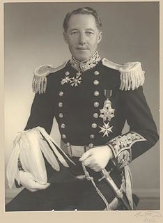
William Charles Arcedeckne Vanneck, 5th Baron Huntingfield, was a British Conservative Party politician, Governor of Victoria, and Administrator of Australia. He was the first Australian-born governor of an Australian state.

Joshua Vanneck, 2nd Baron Huntingfield

Joshua Vanneck, 2nd Baron Huntingfield of Heveningham Hall in Suffolk, was a British peer and Member of Parliament (MP).

Brent Eleigh Human settlement in England

Brent Eleigh is a village and civil parish in the Babergh district of Suffolk, England. Located between Hadleigh and Lavenham, in 2005 it had a population of 180 reducing to 174 at the 2011 Census.

Brandeston village in Suffolk, England

Brandeston is a village in Suffolk, England on the River Deben 11 miles (18 km) northeast of Ipswich. Brandeston is west of Kettleburgh and northwest of Hoo Green. It is a Parish in Plomesgate district and 3½ miles SW of Framlingham r. station."

Clopton, Suffolk Human settlement in England

Clopton is a village and civil parish in Suffolk. It is located between Ipswich and Debenham two kilometres north of Grundisburgh on the River Lark. The village is no larger than a series of houses either side of the B1078, surrounded by farm land. The village itself has no clear centre; houses and other buildings are concentrated around the four manors of Kingshall, Brendhall, Rousehall and Wascolies, all of which are mentioned in the Domesday Book.

Finningham Human settlement in England

Finningham is a village and civil parish in the Mid Suffolk district of Suffolk in the East of England, located approximately 7.5 miles north of Stowmarket and 16 miles from the county town of Ipswich. In 2011 its population was 480.

Great Livermere Human settlement in England

Great Livermere is a village and civil parish in the West Suffolk district of Suffolk in eastern England. It is located around four miles north-east of the borough's largest town Bury St Edmunds.

Stansfield Human settlement in England

Stansfield is a village and civil parish in the West Suffolk district of Suffolk in eastern England. Located seven miles south-west of Bury St Edmunds, in 2011 its population was 221. The village has an Anglican church dedicated to All Saints. In 1870, John Marius Wilson's Imperial Gazetteer of England and Wales described Stansfield as

Tugby and Keythorpe Human settlement in England

Tugby and Keythorpe is a civil parish comprising the village of Tugby and land surrounding Keythorpe Hall, Hall Farm and Lodge Farm in Leicestershire, England, part of the Harborough district. The Parish covers around 2,200 acres, situated 7 miles west of Uppingham, and 12 miles east of Leicester. According to the 2011 census the population of the parish was 330. The Anglican parish register for the parish dates back to 1568. The boundaries of the parish have not changed throughout the years, meaning that the parish's size remains the same as it did in 1568.

Rochford, Worcestershire Human settlement in England

Rochford consists of two hamlets, Lower and Upper Rochford. A civil parish in the Malvern Hills District near Tenbury Wells, in the county of Worcestershire, England, Rochford is 18 miles (29 km) NW of Worcester. The River Teme, which rises in Wales, flows past Lower Rochford and joins the River Severn in Worcester. The chapelry of Rochford was an exclave of Herefordshire, part of the hundred of Wolphy. It was transferred by the Counties Act 1844 to Worcestershire.

Great Moulton Human settlement in England

Great Moulton is a civil parish in the English county of Norfolk. Until the 16th Century it also included the Little Moulton parish.

Roudham and Larling Human settlement in England

Roudham and Larling is a civil parish in the English county of Norfolk. It includes the villages of Roudham and Larling. It covers an area of 15.20 km2 (5.87 sq mi) and had a population of 278 in 119 households at the 2001 census, increasing to a population of 301 in 119 households at the 2011 Census. For the purposes of local government, it falls within the district of Breckland. River Thet flows next to Roudham and Larling.

Great Tey Human settlement in England

Great Tey is a village and civil parish near the villages of Marks Tey and Little Tey in the Colchester borough of Essex, England, located approximately six miles west of Colchester.

Lamarsh Human settlement in England

Lamarsh is a village and a civil parish in the Braintree District, in the county of Essex, England. It is near the large village of Bures and the village of Alphamstone. The village is west of the River Stour. It has a pub, a village hall and a church called The Friends of Holy Innocents Church. The civil parish's name, Lamarsh, comes from the phrase "Loamy marsh". This is derived from the Old English terms lām and mersc, which translate into loam or clay and a marsh respectively.

Kirton, Suffolk Human settlement in England

Kirton is a village and a civil parish in the shire county of Suffolk, England, situated off the A14 road, about 4.5 km (2.8 mi) from Felixstowe and around 10 km (6.2 mi) from Ipswich. The closest train station to Kirton is Trimley. According to the 2011 census, Kirton had a population of 1,146. It is located between the River Deben and the River Orwell. The village of Kirton covers a total area of 8.3 km2 (3.2 sq mi). As the county of Suffolk lacks quarries, many of the buildings are made from flint, clay and timber.

Pettistree Human settlement in England

Pettistree is a small village and a civil parish in the East Suffolk district, in the English county of Suffolk. According to the 2011 Census, Pettistree had a population of 194 people and is set in around 1,800 acres of farmland. The village has many footpaths and country lanes surrounding it. Being only one mile from the larger village of Wickham Market, Pettistree uses many of their resources; such as the Post Office, Medical and Resource Centre and Children's Play Area. The Primary School situated in Wickham Market also serves the younger children of Pettistree. However, senior children are required to travel 7 miles to Thomas Mills High School which is situated in Framlingham.

Heveningham Hall

Heveningham Hall is a Grade I listed building in Heveningham, Suffolk. The first house on the site was built for William Heveningham in 1658. The present house, dating from 1778 to 1780, was designed by Sir Robert Taylor for Sir Gerald Vanneck, 2nd Baronet with interiors by James Wyatt. The hall remained in the Vanneck family until 1981.

Huntingfield, Suffolk Human settlement in England

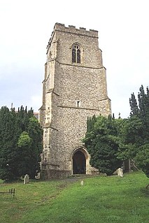
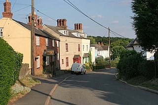
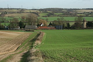
Huntingfield is a village near the B1117 road, in the East Suffolk district, in the county of Suffolk, England. The village is close to the source of the River Blyth and the parish is 12 miles from the seaside town of Southwold. Nearby settlements include the town of Halesworth and the villages of Walpole, Heveningham, Cookley and Laxfield.

References

  1. "Civil Parish population 2011". Neighbourhood Statistics. Office for National Statistics. Retrieved 17 September 2015.
  2. "Church of St Margaret". British Listed Buildings. Retrieved 19 March 2016.
  3. "Heveningham Fair". Country Fair Attractions. 21 March 2016. Retrieved 21 March 2016.
  4. "History of Heveningham". A Vision of Britain Through Time. Vision of Britain. Retrieved 22 April 2016.
  5. "Population Records 1881". A Vision Of Britain Through Time. University of Portsmouth. 22 April 2016. Retrieved 22 April 2016.
  6. "Adult lifestage- population statistics Heveningham". Neighbourhood Statistics. Office for National Statistics. Retrieved 24 April 2016.
  7. "Adult lifestage- Population Statistics". Neighbourhood Statistics. Office for National Statistics. Retrieved 24 April 2016.
  8. "Adult Lifestafe- Population Statistics". Neighbourhood Statistics. Office for National Statistics. Retrieved 24 April 2016.
  9. "Ethnic Group 2011". Neighbourhood Statistics. Office for National Statistics. Retrieved 20 April 2016.
  10. "Ethnic Groups 2011". Neighbourhood Statistics. Office for National Statistics. Retrieved 22 April 2016.
  11. "1881 Occupational Orders". A Vision Of Britain Through Time. University of Portsmouth. Retrieved 24 April 2016.
  12. "1881 Occupational Orders". A Vision of Britain Through Time. University of Portsmouth. Retrieved 24 April 2016.
  13. "Industry in Heveningham". Neighbourhood Statistics. Office for National Statistics. Retrieved 24 April 2016.
  14. "Industry- Females 2011". Neighbourhood Statistics. Office for National Statistics. 20 March 2016. Retrieved 20 March 2016.
  15. "Industry- Males 2011". Neighbourhood Statistics. Office for National Statistics. 20 March 2016. Retrieved 20 March 2016.
  16. Reynolds, Bruce (1995). Bruce Reynolds: The Autobiography of a Thief. Bantam Press. p. 5. ISBN   978-0-7535-3917-0.