
Suffolk is an East Anglian county of ancient origin in England. It has borders with Norfolk to the north, Cambridgeshire to the west and Essex to the south. The North Sea lies to the east. The county town is Ipswich; other important towns include Lowestoft, Bury St Edmunds, Newmarket, and Felixstowe, one of the largest container ports in Europe.

Forest Heath was a local government district in Suffolk, England. Its council was based in Mildenhall. Other towns in the district included Newmarket. The population of the district at the 2011 Census was 59,748.
West Suffolk was an administrative county of England created in 1889 from part of the county of Suffolk. It survived until 1974 when it was rejoined with East Suffolk. Its county town was Bury St Edmunds.

St Edmundsbury was a local government district and borough in Suffolk, England. It was named after its main town, Bury St Edmunds. The second town in the district is Haverhill. The population of the district was 111,008 at the 2011 Census.

Thingoe Rural District was a rural district in the county of West Suffolk, England. It was created in 1894. On 1 April 1935 the parish of Depden was transferred to the Clare Rural District. On the same date the district was enlarged by the transfer of the civil parishes of Barnham, Barningham, Coney Weston, Euston, Fakenham Magna, Hepworth, Honington, Hopton, Knettishall, Market Weston, Sapiston, and Thelnetham from the disbanded Brandon Rural District.

Bury St Edmunds is a constituency represented in the House of Commons of the UK Parliament since 2015 by Jo Churchill, a Conservative.
South Suffolk is a constituency represented in the House of Commons of the UK Parliament since 2015 by James Cartlidge, a Conservative.
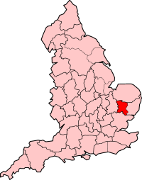
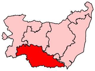
West Suffolk is a constituency represented in the House of Commons of the UK Parliament since 2010 by Matt Hancock, a Conservative. Between 1832 and 1885 there had also been a constituency, the Western Division of Suffolk that had also been called West Suffolk. It is currently represented by Matt Hancock, a Conservative. He has been the MP since 2010 and is currently the Health Secretary.
Barnardiston is a village and civil parish in the West Suffolk district of Suffolk, England. The village is located about four miles north-east of Haverhill off the A143.
The Diocese of St Edmundsbury and Ipswich is a Church of England diocese based in Ipswich, covering Suffolk. The cathedral is St Edmundsbury Cathedral, and the bishop is the Bishop of St Edmundsbury and Ipswich. It is part of the Province of Canterbury.
The Cambridgeshire County Football League, currently styled as the Kershaw Cambridgeshire County League for sponsorship purposes, is a football competition covering Cambridgeshire and western parts of Suffolk and Norfolk in England. It has a total of 13 divisions, headed by the Premier Division. The Premier Division sits at step 7 of the National League System. Below the Premier Division lies the Senior A Division and Senior B Division. Below those two leagues, the structure splits into two parallel ladders of five divisions each. The Premier Division champions may apply for promotion to the Eastern Counties League Division One but few take up the offer. For instance, at the end of the 2012–13 season, Great Shelford, traditionally one of the stronger sides in the league, were the Premier Division champions, but did not apply for promotion.
This is a list of Sheriffs and High Sheriffs of Suffolk.

Withersfield is a village and civil parish in the West Suffolk district of Suffolk in eastern England. In 2011 its population was 450. The village has a public house and a village hall. Withersfield centres on the parish church, St Mary the Virgin. The village is set in a rural location, surrounded by farmland, yet is also only a mile north from the busy market town of Haverhill. Surrounding villages include Great Wratting, West Wickham and Great Thurlow.
Rougham is a village and former civil parish 19 miles (31 km) north west of Ipswich, now in the parish of Rushbrooke with Rougham, in the West Suffolk district, in the county of Suffolk, England. Until April 2019 Rougham was in the St Edmundsbury district. In 1961 the parish had a population of 777. Rougham is also a ward, in 2011 the ward had a population of 2341. The ward touches Chadacre, Thurston, Rattlesden, The Fornhams & Great Barton, Moreton Hall, Lavenham, Horringer and Southgate. Rougham is pronounced "Ruff'm". In 1958 the parish had settlements at Mouse Lane estate, Rougham Green, Kingshall Street and Chapmans Close.
Thingoe North Division is an electoral division in Suffolk which returns one county councillor to Suffolk County Council. Its made up of the villages surrounding the Northern half of Bury St Edmunds and consists of the West Suffolk council wards of The Fornhams & Great Barton, Pakenham & Troston, and Risby excluding the parish of Icklingham which is part of Row Heath Division.
Thingoe South Division is an electoral division in Suffolk which returns one county councillor to Suffolk County Council. It is made up of the villages surrounding the Southern half of Bury St Edmunds and consists of the West Suffolk council wards of Barrow, Horringer, and Rougham along with parts of Moreton Hall, Whepstead & Wickhambrook, and Chedburgh & Chevington.


