| Pakenham | |
|---|---|
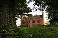
 Pakenham Water Mill | |
 Pakenham Location within Suffolk | |
| Population | 922 (2011) [1] |
| OS grid reference | TL924673 |
| District | |
| Shire county | |
| Region | |
| Country | England |
| Sovereign state | United Kingdom |
| Post town | Bury St Edmunds |
| Postcode district | IP31 |
| Dialling code | 01359 |
| UK Parliament | |
Pakenham is a village and civil parish in the West Suffolk district of Suffolk in eastern England. Its name can be linked to Anglo-Saxon roots, Pacca being the founder of a settlement on the hill surrounding Pakenham church. The village describes itself as the "Village of Two Mills", as it has a water mill which claims to be the only working example in the county. [2] Pakenham Windmill has been restored and is maintained in working order.
Contents
The village sits to the east of Bury St. Edmunds. From 1974 to 2019 it was administered as part of the borough of St Edmundsbury. Prior to the local government reorganisation of 1974 it was part of Thingoe Rural District.