Fornham St Martin

Last updated

Fornham St Martin
Fornham St. Martin cum Fornham St. Genevieve village sign - geograph.org.uk - 4292713.jpg
Village sign Fornham St Martin
Suffolk UK location map.svg
Red pog.svg
Fornham St Martin
Location within Suffolk
Population1,300 (2005) [1]
1,319 (2011) [2]
District
Shire county
Region
Country England
Sovereign state United Kingdom
Post town Bury St Edmunds
Postcode district IP28, IP31
Police Suffolk
Fire Suffolk
Ambulance East of England
List of places
UK
England
Suffolk
52°16′19″N0°42′50″E / 52.272°N 0.714°E / 52.272; 0.714

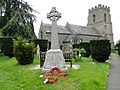
Fornham St Martin is a village and civil parish in the West Suffolk district of Suffolk in eastern England. Located on the northern outskirts of Bury St Edmunds off east and west from the A134, in 2005 its population was 1300. [1] Its parish council is shared with neighbouring Fornham St Genevieve, and is known as Fornham St Martin cum St Genevieve Parish Council. Fornham St Martin is one of a trio of contiguous villages by the River Lark. The other villages are Fornham St Genevieve and Fornham All Saints.

Contents

Near the current Lark Valley Drive, a smock windmill used to stand. It collapsed in 1927.[ citation needed ]

The village has one public house, the Woolpack, but no shops. Its school closed in the early 1950s.[ citation needed ]

History

The word Fornham means 'Trout village' derived from the Old English words forne meaning trout and hām meaning village with the addition of the dedication to Martin of Tours. [3] The village is recorded in the Domesday Book with 27 households in 1086 made up of 3 villagers, 11 freemen, 10 smallholders, 3 slaves along with 2 cobs, 4 cattle, 12 pigs, and 80 sheep. [4]

The Battle of Fornham, a significant battle in English history, took place in Fornham Park and the surrounding area in 1173. This was part of the Revolt of 1173–74 where King Henry II, led by Robert de Lucy fought the Flemish rebels for his son, Henry the Young King, led by Robert de Beaumont, 3rd Earl of Leicester. Scribes of the time variously estimated that between 3000 and 10,000 Flemish mercenaries were slaughtered and lie beneath the fields, woodland and ditches. [5]

The village appears on John Speed's 1610 map as "Fernham mertin" and in 1870–72, John Marius Wilson's Imperial Gazetteer of England and Wales described the town as a parish in Thingoe district, Suffolk in the Diocese of Ely; on the river Lark, 1¾ mile North of Bury St Edmunds and related that it had 74 houses, a post office, a church and a free school. [6]

Architect Robert Abraham was involved with the expansion of Fornham Hall in the 19th century.[ citation needed ]

Church

Fornham St Martin Church (OS grid TL8566) with King George's playing field across the way at the south end of B1106 to the village. The churchyard contains a number of notable burials:

See also

Commons-logo.svg Media related to Fornham St Martin at Wikimedia Commons

Related Research Articles

<span class="mw-page-title-main">Robert de Beaumont, 3rd Earl of Leicester</span> English nobleman (1104–1168)

Robert de Beaumont, 3rd Earl of Leicester was an English nobleman, one of the principal followers of Henry the Young King in the Revolt of 1173–1174 against his father King Henry II. He is also called Robert Blanchemains.

<span class="mw-page-title-main">Culford</span> Village and civil parish in Suffolk, United Kingdom

Culford is a village and civil parish about 4 miles (6 km) north of Bury St Edmunds and 62 miles (100 km) north east of London in the West Suffolk district of Suffolk, England.

<span class="mw-page-title-main">Alpheton</span> Human settlement in England

Alpheton is a village and civil parish in the Babergh district of Suffolk, England. Located on the A134 road about six miles north of Sudbury, in 2005 it had a population of 260, reducing to 256 at the 2011 Census. According to Eilert Ekwall the meaning of the village name is the homestead of Aelfled.

<span class="mw-page-title-main">Beyton</span> Human settlement in England

Beyton is a village and civil parish in the Mid Suffolk district of the English county of Suffolk. The village is around 8 miles (13 km) east of Bury St Edmunds, 2 miles (3.2 km) south-east of Thurston and 8 miles (13 km) north-west of Stowmarket. The main Ipswich to Bury St Edmunds road used to pass through the village – the modern A14 dual carriageway bypasses the village to the north.

<span class="mw-page-title-main">Flempton</span> Human settlement in England

Flempton is a village and civil parish in the West Suffolk district of Suffolk, England. It is on the A1101 road 5 miles NW from Bury St Edmunds.

<span class="mw-page-title-main">Glemsford</span> Human settlement in England

Glemsford is a village in the Babergh district in Suffolk, England, near the town of Sudbury. Glemsford is located near the River Glem and the River Stour also flows nearby. Glemsford is surrounded by arable farmland and is not far from historic Suffolk villages such as Lavenham and Long Melford.

<span class="mw-page-title-main">Hengrave</span> Human settlement in England

Hengrave is a small village and civil parish in the West Suffolk district, in the county of Suffolk, England. It is to the North the town of Bury St Edmunds along the A1101 road. It is surrounded by the parishes of Flempton, Culford, Fornham St Genevieve, Fornham All Saints and Risby. The River Lark provides the North East boundary of the parish.

<span class="mw-page-title-main">Layham</span> Human settlement in England

Layham is a small village and a civil parish in southern Suffolk, England, situated between the town of Hadleigh and the neighbouring village of Raydon.

<span class="mw-page-title-main">Gilstrap baronets</span> Extinct baronetcy in the Baronetage of the United Kingdom

The Gilstrap Baronetcy, of Fornham St Genevieve in the County of Suffolk and of the High Beeches in the Parish of Slaugham in the County of Sussex, was a title in the Baronetage of the United Kingdom.

<span class="mw-page-title-main">Thorpe Morieux</span> Human settlement in England

Thorpe Morieux is a small village and civil parish in Suffolk, England. It is 10 miles south-east of Bury St Edmunds and 10 miles north east of Sudbury.

<span class="mw-page-title-main">Worlington, Suffolk</span> Village in Suffolk, England

Worlington is a village and civil parish in the English county of Suffolk and in the old hundred of Lackford.

<span class="mw-page-title-main">Hinderclay</span> Human settlement in England

Hinderclay is a village and civil parish in the Mid Suffolk district of Suffolk in eastern England. The village is located around 14 miles (23 km) - from Bury St Edmunds in an area of rolling arable land to the south of the Little Ouse river valley. Neighbouring villages include Thelnetham and Rickinghall. In 2005 its population was 340. The parish also contains the hamlet of Thorpe Street.

<span class="mw-page-title-main">Westley, Suffolk</span> Human settlement in England

Westley is a village and civil parish in the West Suffolk district of Suffolk in eastern England. It is located south of Junction 42 of the A14 providing primary access to adjacent market towns Bury St Edmunds (East) and Newmarket (West). The village consists of two central roads: Fornham Lane and Hill Road running north and south through the parish, with adjoining roads accommodating Westley's total population of 183.

<span class="mw-page-title-main">Fornham All Saints</span> Human settlement in England

Fornham All Saints is a village and civil parish in Suffolk, England in the West Suffolk district. It is north-northwest of the town of Bury St Edmunds and 500m west of Fornham St Genevieve. Fornham All Saints is one of a trio of contiguous villages by the River Lark. The other villages are Fornham St Genevieve and Fornham St Martin.

<span class="mw-page-title-main">Fornham St Genevieve</span> Human settlement in England

Fornham St Genevieve is a village and civil parish in the West Suffolk district of Suffolk in eastern England. It is one of a trio of contiguous villages by the River Lark. The other villages are Fornham All Saints and Fornham St Martin.

<span class="mw-page-title-main">South Cove, Suffolk</span> Human settlement in England

South Cove is a civil parish in the east of the English county of Suffolk. It is 3 miles (4.8 km) north of the coastal town of Southwold and 1 mile (1.6 km) south of the village of Wrentham in the East Suffolk district. Neighbouring parishes include Covehithe, Frostenden and Reydon as well as Wrentham. The village lies to the east of the main A12 road, on the B1127 road between Wrentham and Southwold, and is around 1+12 miles (2.4 km) from the North Sea coast.

<span class="mw-page-title-main">Fornham Hall</span>

Fornham Hall was a large 18th-century country house near Bury St Edmunds. It was demolished in 1957. The Estate included manorial land is part of the parish of Fornham St Genevieve.

The Battle of Fornham was a battle that was fought during the Revolt of 1173–1174.

<span class="mw-page-title-main">West Suffolk District</span> Non-metropolitan district in England

West Suffolk District is a local government district in Suffolk, England. It was established in 2019 as a merger of the previous Forest Heath District with the Borough of St Edmundsbury. The council is based in Bury St Edmunds, the district's largest town. The district also contains the towns of Brandon, Clare, Haverhill, Mildenhall and Newmarket, along with numerous villages and surrounding rural areas.

Thingoe North Division is an electoral division in Suffolk which returns one county councillor to Suffolk County Council. Its made up of the villages surrounding the Northern half of Bury St Edmunds and consists of the West Suffolk council wards of The Fornhams & Great Barton, Pakenham & Troston, and Risby excluding the parish of Icklingham which is part of Row Heath Division.

References

  1. 1 2 Estimates of Total Population of Areas in Suffolk Archived December 19, 2008, at the Wayback Machine Suffolk County Council
  2. "Civil Parish population 2011". Neighbourhood Statistics. Office for National Statistics. Archived from the original on 13 October 2016. Retrieved 21 August 2016.
  3. "Key to English Place-names". kepn.nottingham.ac.uk. Retrieved 26 May 2020.
  4. "Fornham [St Martin] | Domesday Book". opendomesday.org. Retrieved 26 May 2020.
  5. "Battle of Fornham". Suffolk Archives. Retrieved 26 May 2020.
  6. Fornham St Martin Suffolk Britain through time Website