
Hadleigh is an ancient market town and civil parish in the Babergh district of Suffolk, England. The town is situated next to the River Brett, between the larger towns of Sudbury and Ipswich. It had a population of 8,253 at the 2011 census. The headquarters of Babergh District Council were located in the town until 2017.
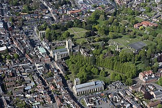
Bury St Edmunds, commonly referred to locally as Bury, is a cathedral as well as market town and civil parish in the West Suffolk district, in the county of Suffolk, England. The town is best known for Bury St Edmunds Abbey and St Edmundsbury Cathedral. Bury is the seat of the Diocese of St Edmundsbury and Ipswich of the Church of England, with the episcopal see at St Edmundsbury Cathedral. In 2011, it had a population of 45,000. The town, originally called Beodericsworth, was built on a grid pattern by Abbot Baldwin around 1080. It is known for brewing and malting and for a British Sugar processing factory, where Silver Spoon sugar is produced. The town is the cultural and retail centre for West Suffolk and tourism is a major part of the economy.
Forest Heath was a local government district in Suffolk, England. Its council was based in Mildenhall. Other towns in the district included Newmarket. The population of the district at the 2011 Census was 59,748.

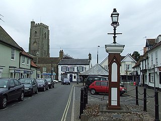
Lavenham is a village, civil parish and electoral ward in the Babergh district, in the county of Suffolk, England. It is noted for its Guildhall, Little Hall, 15th-century church, half-timbered medieval cottages and circular walks. In the medieval period it was among the twenty wealthiest settlements in England. In 2011 the parish had a population of 1722.

Long Melford, colloquially and historically also referred to as Melford, is a large village and civil parish in the Babergh district, in the county of Suffolk, England. It is on Suffolk's border with Essex, which is marked by the River Stour, 3 miles (4.8 km) from Sudbury, approximately 16 miles (26 km) from Colchester and 14 miles (23 km) from Bury St Edmunds. It is one of Suffolk's "wool towns" and is a former market town. The parish also includes the hamlets of Bridge Street and Cuckoo Tye. In 2011 the parish had a population of 3918.

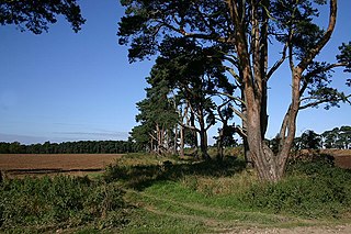
Culford is a village and civil parish about 4 miles (6 km) north of Bury St Edmunds and 62 miles (100 km) north east of London in the West Suffolk district of Suffolk, England.

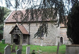
Whepstead is a village and civil parish in the West Suffolk district of Suffolk in eastern England, located south of Bury St Edmunds. Once the property of Bury Abbey it became a possession of the Drury family at the Dissolution of the Monasteries in the 16th century. Whepstead Church is dedicated to St Petronilla the only such dedication in England.

Japanese in the United Kingdom include British citizens of Japanese ancestry or permanent residents of Japanese birth or citizenship, as well as expatriate business professionals and their dependents on limited-term employment visas, students, trainees and young people participating in the UK government-sponsored Youth Mobility Scheme.

Poslingford is a village and civil parish in the West Suffolk district of Suffolk in eastern England, with a stream that feeds the into the Chilton stream and then the Suffolk Stour. The village follows the line of The Street, rising approximately 140 metres in height above sea level from south to north.
Bradfield Combust is a village and former manor and civil parish, now in the parish of Bradfield Combust with Stanningfield, the West Suffolk district, in Suffolk, England, located on the A134 between Windsor Green and Great Whelnetham. In 1961 the parish had a population of 108. In 1988 the parish was merged with Stanningfield to form "Bradfield Combust with Stanningfield".

Shimpling is a village and civil parish in south Suffolk, England. About 7 miles (11 km) from Bury St Edmunds, it is part of Babergh district. The village is formed from two halves, the newer Shimpling Street and about 2 miles (3 km) away the old village of Shimpling. The village has a Church of England parish church, where supermodel Claudia Schiffer and film producer Matthew Vaughn were married on 25 May 2002.

Lawshall is a village and civil parish in Suffolk, England. Located around a mile off the A134 between Bury St Edmunds and Sudbury, it is part of Babergh district. The parish has nine settlements comprising the three main settlements of The Street, Lambs Lane and Bury Road along with the six small hamlets of Audley End, Hanningfield Green, Harrow Green, Hart's Green, Hibb's Green and Lawshall Green.
Haughley is a village and civil parish in the Mid Suffolk district of Suffolk, England. The village is located 2 miles (3.2 km) northwest of the town of Stowmarket, overlooking the Gipping valley, next to the A14 corridor. The population recorded in 2011 was 1,638. Mentioned in the Domesday Book, it was the site of a castle, a church on the pilgrim's route to Bury St Edmunds Abbey, and a market. Adjacent farms on the north side of the village were also home to one of the first studies of organic farming and the first headquarters of the Soil Association.

Withersfield is a village and civil parish in the West Suffolk district of Suffolk in eastern England. In 2011 its population was 450. It has a public house and a village hall, and centres on the parish church, St. Mary the Virgin. It is in a rural location, surrounded by farmland, yet only a mile north of the busy market town of Haverhill. Surrounding villages include Great Wratting, West Wickham and Great Thurlow.
Westley is a village and civil parish in the West Suffolk district of Suffolk in eastern England. It is located south of Junction 42 of the A14 providing primary access to adjacent market towns Bury St Edmunds (East) and Newmarket (West). The village consists of two central roads: Fornham Lane and Hill Road running north and south through the parish, with adjoining roads accommodating Westley's total population of 183.

Chevington is a village and civil parish in the West Suffolk district of Suffolk in East Anglia, England. Located around 10 km south-west of Bury St Edmunds, in 2005 its population was 630, reducing to 602 at the 2011 Census. The parish also contains the hamlets of Broad Green and Tan Office Green.

Nowton is a small village and civil parish in the West Suffolk district of Suffolk in eastern England. Located on the southern edge of Bury St Edmunds, in 2005 its population was estimated to be 140. At the 2011 census 163 people were recorded as living in the village.

Bury Road, Lawshall is a linear settlement in the civil parish of Lawshall in the Babergh district in the county of Suffolk, England. The northern part of the settlement is in the civil parish of Bradfield Combust with Stanningfield in West Suffolk. Bury Road is located between Hawstead and Lambs Lane / The Glebe and is two miles off the A134 between Bury St Edmunds and Sudbury.
West Suffolk District is a local government district in Suffolk, England. It was established in 2019 as a merger of the previous Forest Heath District with the Borough of St Edmundsbury. The council is based in Bury St Edmunds, the district's largest town. The district also contains the towns of Brandon, Clare, Haverhill, Mildenhall and Newmarket, along with numerous villages and surrounding rural areas. In 2021 it had a population of 180,820.
Shi-Tennoji School in UK was a Japanese international secondary school in Herringswell, Suffolk, England, United Kingdom, near Bury St Edmunds. The Japanese government classified the school as a Shiritsu zaigai kyoiku shisetsu or an overseas branch of a Japanese private school. Shi-tennoji International Limited owned the school, and the organisation intended to develop Japan-United Kingdom relations with the school.


