Stanton, Suffolk

Last updated

Stanton
Upthorpe Mill, Stanton.jpg
Upthorpe Mill
Suffolk UK location map.svg
Red pog.svg
Stanton
Location within Suffolk
Population2,507 (2011 census) [1]
OS grid reference TL967734
District
Shire county
Region
Country England
Sovereign state United Kingdom
Post town BURY ST. EDMUNDS
Postcode district IP31
Police Suffolk
Fire Suffolk
Ambulance East of England
List of places
UK
England
Suffolk
52°19′26″N0°53′06″E / 52.324°N 0.885°E / 52.324; 0.885 Coordinates: 52°19′26″N0°53′06″E / 52.324°N 0.885°E / 52.324; 0.885

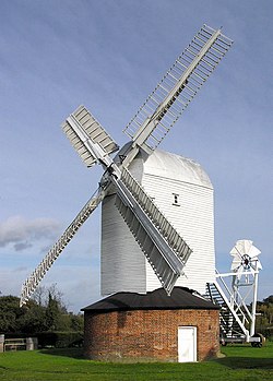
Stanton is a village and civil parish in the West Suffolk district of Suffolk in eastern England, about nine miles north-east of Bury St Edmunds, on the A143 road to Diss. Close to the village lies the former WW II airfield RAF Shepherds Grove, where American forces were based. One of the main landmarks in the village is the fine restored windmill at Upthorpe Farm, to the east of the village. The name " Stanton" means 'a homestead on stony ground'.

Contents

History

It's believed the site of the village has been continuously occupied since Roman times [2]

Stanton dates back to Roman times, sited at the junction of Peddars Way and the Roman road believed to run between Camulodunum (Colchester) and Bildeston. The site of a Roman Villa known as 'Stanton Chare' is at the junction of the two ancient routes.

The Manor of Stanton was held for many years by Abbots of Bury St Edmunds, and subsequently by the Capell Lofft family name.

The present parish was formed from two earlier parishes, Stanton All Saints and Stanton St John. The former St John's Church, on a prominent hill outside the village, was abandoned and services continued at All Saints in the village centre.

Upthorpe Mill

Upthorpe Mill was built in 1751 at a site on the other side of the village to where it is today. It was moved to its present site in 1808 and worked until the First World War. Repairs carried out in 1939 returned it to working order and the mill was restored in 1990.

Schools

There is a Primary school, Stanton Pre-School and a nursery. The primary school predominantly feeds through to either Ixworth free school or Thurston Community College.

Miscellaneous

The eleven member Parish Council meets on the second Thursday of every month in the Terry Bray room of the village hall.

The one local pub is 'The Cock Inn'

There are two open churches, All Saints (Church of England), and a Methodist church. The disused church of St Johns holds occasional services. All Saints and St Johns are part of the United Benefice of Stanton, Hopton, Market Weston, Barningham & Coney Weston.

There are number of businesses in the village; a post office and newsagents, a fish and chips shop, hairdressers and Palmers Bakery.

Stanton has a football team Stanton F.C..

In 2010 the 1st Stanton Brownies moved to Ixworth and became the 1st Ixworth Brownies.

Stanton Woods is a biological Site of Special Scientific Interest south of the village.

Related Research Articles

Honington, Suffolk Village in West Suffolk, England

Honington is a village and civil parish in the West Suffolk district of Suffolk in eastern England, near to the border with Norfolk. It lies on the River Black Bourn, about 8 miles from Bury St Edmunds and 6 miles from Thetford, Norfolk. Much of the farmland belongs to the estate of the Duke of Grafton. The village is known for its RAF station, RAF Honington. It is also near two joint RAF/USAF airfields: RAF Lakenheath and RAF Mildenhall. Honington was the birthplace of the poet Robert Bloomfield.

Norton, Suffolk Human settlement in England

Norton is a village and civil parish in the Mid Suffolk district of the English county of Suffolk. The name Norton means northern town or farm. Located close to the A14, its nearest railway station is at Elmswell, just over 3 miles (5 km) away. The closest towns are Stowmarket 8 miles (13 km) away and Bury St Edmunds, around 10 miles (16 km) away.

Borough of St Edmundsbury Borough & Non-metropolitan district in England

St Edmundsbury was a local government district and borough in Suffolk, England. It was named after its main town, Bury St Edmunds. The second town in the district is Haverhill. The population of the district was 111,008 at the 2011 Census.

Thingoe Rural District

Thingoe Rural District was a rural district in the county of West Suffolk, England. It was created in 1894. On 1 April 1935 the parish of Depden was transferred to the Clare Rural District. On the same date the district was enlarged by the transfer of the civil parishes of Barnham, Barningham, Coney Weston, Euston, Fakenham Magna, Hepworth, Honington, Hopton, Knettishall, Market Weston, Sapiston, and Thelnetham from the disbanded Brandon Rural District.

Sapiston Human settlement in England

Sapiston is a small village and civil parish in the West Suffolk district of Suffolk in eastern England, located near the Suffolk-Norfolk border. It is in northern Suffolk lying on the river Blackbourn. The place-name 'Sapiston' is first attested in the Domesday Book of 1086, where it appears as Sapestuna. The name is thought to mean 'village of soapmakers', but this is not certain.

Troston Human settlement in England

Troston is a village and civil parish in the English county of Suffolk.

Bardwell, Suffolk Human settlement in England

Bardwell is a village and civil parish in the West Suffolk district of Suffolk, England.

Barningham, Suffolk Human settlement in England

Barningham is a village and civil parish in the West Suffolk district of Suffolk, England, about twelve miles north-east of Bury St Edmunds. According to Eilert Ekwall, the meaning of the village name is the homestead of Beorn's people. The Domesday Book records the population of Barningham in 1086 to be 36. It has a primary school, a pub called the Royal George, a shop with a post office, a church, a hairdresser's, a village hall and a flower shop.

Beyton Human settlement in England

Beyton is a village and civil parish in the Mid Suffolk district of the English county of Suffolk. The village is around 8 miles (13 km) east of Bury St Edmunds, 2 miles (3.2 km) south-east of Thurston and 8 miles (13 km) north-west of Stowmarket. The main Ipswich to Bury St Edmunds road used to pass through the village – the modern A14 dual carriageway bypasses the village to the north.

Coney Weston Human settlement in England

Coney Weston is a village and civil parish in Suffolk, England, within the West Suffolk district. It is a primarily rural residential town that has dormitory town status. It is 5 miles (8 km) north of Ixworth and 12 miles (19 km) from Bury St Edmunds

Lawshall Human settlement in England

Lawshall is a village and civil parish in Suffolk, England. Located around a mile off the A134 between Bury St Edmunds and Sudbury, it is part of Babergh district. The parish has nine settlements comprising the three main settlements of The Street, Lambs Lane and Bury Road along with the six small hamlets of Audley End, Hanningfield Green, Harrow Green, Hart's Green, Hibb's Green and Lawshall Green.

Ixworth Human settlement in England

Ixworth is a village and civil parish in the West Suffolk district of the English county of Suffolk. It is 6 miles (9.7 km) north-east of Bury St Edmunds on the A143 road to Diss and 9 miles (14 km) south-east of Thetford. The parish has a population of 2,177, increasing to 2,365 at the 2011 Census. The south end of High Street and town may also be historically listed as Ixworth St Mary.

Stowlangtoft Human settlement in England

Stowlangtoft is a village and civil parish in the Mid Suffolk district of Suffolk in eastern England two miles south-east from Ixworth. Located around five miles north-east of Bury St Edmunds, in 2005 its population was 270.

Ixworth Thorpe Human settlement in England

Ixworth Thorpe is a small village and civil parish in the West Suffolk district of the English county of Suffolk. The village is located on the A1088 road around 2 miles (3.2 km) north-west of the larger village of Ixworth and 7 miles (11.3 km) north-east of Bury St Edmunds. In 2005 its estimated population was 60. The parish council is operated jointly with Ixworth. From the 2011 Census the population of the village was not recorded separately.

Wickhambrook Human settlement in England

Wickhambrook is a village and civil parish in the West Suffolk district of Suffolk in eastern England. It is about ten miles (16 km) south-west from Bury St Edmunds, halfway to Haverhill, off the A143 road. Wickhambrook is the largest village by area in the county of Suffolk with a population of 1170 in 2005.

Hopton, Suffolk Human settlement in England

Hopton is a village and civil parish in the West Suffolk district of Suffolk in eastern England. Located just south of the Norfolk border on the B1111 road between Stanton and Garboldisham, in 2005 it had a population of 650. It shares a parish council with neighbouring Knettishall.

All Saints Church, Lawshall Church in Suffolk, England

The Parish Church of All Saints' Lawshall, is an Anglican church in the village of Lawshall, Suffolk, England. It has been designated by English Heritage as a Grade I listed building. The church is located in between Lawshall Hall and All Saints CEVCP Primary School. The church is part of the St Edmund Way Benefice, whose Rector is Revd Jeremy Parsons.

West Suffolk (district) Non-metropolitan district in England

West Suffolk is a local government district in Suffolk, England, which was established on 1 April 2019, following the merger of the existing Forest Heath district with the borough of St Edmundsbury. The two councils had already had a joint Chief Executive since 2011. At the 2011 census, the two districts had a combined population of 170,756.

References

  1. "Civil Parish population 2011". Neighbourhood Statistics. Office for National Statistics. Retrieved 28 August 2016.
  2. "Local History". stanton.onesuffolk.net. Retrieved 23 October 2015.