Stratford St Andrew

Last updated

Stratford St Andrew
Stratford St.Andrew Church - geograph.org.uk - 248660.jpg
Suffolk UK location map.svg
Red pog.svg
Stratford St Andrew
Location within Suffolk
Population185 (2011) [1]
OS grid reference TM357602
District
Shire county
Region
Country England
Sovereign state United Kingdom
Post town Saxmundham
Postcode district IP17
UK Parliament
List of places
UK
England
Suffolk
52°11′56″N1°26′49″E / 52.199°N 1.447°E / 52.199; 1.447
Total population of Stratford St Andrew, Suffolk, as reported by the Census of Population from 1801 to 2011 Stratford St Andrew population time series 1801-2011.jpg
Total population of Stratford St Andrew, Suffolk, as reported by the Census of Population from 1801 to 2011

Stratford St Andrew is a small village and a civil parish just off the A12 road, in the East Suffolk district, in the English county of Suffolk. It lies 3 miles south west of Saxmundham, the nearest town.

Contents

The parish had a population of 185 at the 2011 census. [2]

History

Stratford St Andrew has the origins of its name traced back to a combination of Anglican and Old English. It translates as, 'Ford on a Roman road', with this being a later affix from the church dedication. [3]

In the Domesday book of 1086, Stratford St Andrew was situated in the Plomesgate district, under the ownership of Walter Giffard, who was recorded as the Tenant-in-chief. The value of the land to the Lord, Ralph of Lanquetot, was said to be £2.4. [4] The village was recorded as having 25 households, containing 5 smallholders and 13.5 free men. The Domesday records also state that there was a 4-acre meadow, along with a single mill. In terms of livestock it is reported that there were 2 cattle, 15 pigs, 30 sheep and 27 goats in 1086. [5]

Stratford St Andrew was given its name because Suffolk has two Stratfords. The other Stratford, titled Stratford St Mary, is located 30 miles down the A12 and is of no direct relation. [6] In the 1870s, Stratford St Andrew was described as:

"a parish in Plomesgate district, Suffolk; 3 miles SW of Saxmundham r. station.Real property, £1,373. Pop., 181. Houses, 43. The manor belongs to Earl Guilford." [7]

The current (1990) Lord of Stratford St. Andrew is the Hon. Douglas Densmore,CSt.J. and Knight Officer of the Order of Saints Maurice and Lazarus. Up until the early 21st century, the village had a church, this church representing the Church of England faith. However, in 1992, the church was declared redundant. [8] The church was first noted as being run down in the 1970s, when it was described as:

"dully Victorian, a middle-brow lukewarm ritualist restoration from the 1870s." [9]

It was also described as having smashed windows, rusty hooks and an old open chest simply abandoned on the floor. The vestry door was said to be hanging off on its hinges. [10]

The church had been founded in 1692 and was dedicated to St. Andrew. [11] Ranulph do Glanville, the famous justiciary of England during the reign of Henry II, was born in Stratford St Andrew. [12]

The village sign for Stratford St Andrew shows the mill, of which little now remains. Whilst the black swan, which can be seen on the sign, is a reminder of a coaching inn, named the 'Black Swan'. This inn no longer exists. [13] The coat of arms for the village reads:

"confide recte agens." [14]

This translates as 'doing rightly, be confident.' [15]

Demographics

Since 1801, the total population of Stratford St Andrew has gradually declined from 203, [16] to 185 in 2011. 1821 saw the village reach its peak total population with 213 inhabitants. In contrast, 1961 saw the lowest total population for the village, with 158 recorded inhabitants. Despite the decline in total population, the number of houses in the village has increased. In 1831, when the total population was 200, the number of houses was recorded as 24. [17] By 1961, there were 58 households, even though the total population was at its recorded lowest, 158. The most recent census data in 2011, reports that there are now 78 households in the village, 43% of which are owned outright. [18] The reasoning behind the increase in households may be partially explained by the increase in area of Stratford St Andrew. In 1831 the total area was 300 acres, however 60 years later in 1891, the village was 800 acres large. [19] This increase in land would allow more room for houses to be built, thus partially explaining why there is an increase in the recorded number of households.

In 1831, working in agricultural labour was the largest sector of employment for those living in Stratford St Andrew. There were only 5 employers and professionals. [20] In 2011 there were 95 people from the village in employment. Of those 95, only four were involved in agricultural labour. The majority are now involved in retail related work, as well as education. [21]

Amenities

Stratford St Andrew formerly had a place of worship, but today the church has been converted into a private residence. It retains its structural presence, made up of a tall plain tower, with simple decorated bell windows. [22] Today, the nearest operating church to the village is located less than half a mile to the east in Farnham, just over the River Alde. The church is named St Mary's Church and has been in existence since 12th century Norman. [23] Stratford St Andrew also has a village hall named the 'Riverside Centre'. Within the boundaries of Stratford St Andrew and just off the main A12 road is a garage. This garage contains a Shell petrol station.

Village Hall

Stratford St Andrew contains a village hall. It was originally known as the 'Hut', and was built shortly after the First World War for the use of ex-servicemen.

However, by 1995, the 'Hut' was becoming run-down and reaching the end of its lifetime. So in November that year, the newly elected committee began raising funds for a new hall. In April 1998 the National Lottery Fund awarded a grant of £185,000 towards the project. Together with support from Suffolk Coastal District, Waste Recycling Environmental Limited, Rural Development Council and Carnegie Trust, construction of the new hall was able to commence on 1 June 1998.

In February 1999 building of the new hall was completed. It had taken less than a year to construct, largely due to help from over 120 volunteers. The official opening was 4 March 1999, where it was opened by Lord Belstead, and was named the 'Riverside Centre'.

The hall comprises a store room, members lounge and games room. Outside there is a floodlit patio and play area, as well as a basketball area. The centre offers Pilates and Tango classes, hosts Ladies' and Men's darts, and is available for bookings. [24]

Related Research Articles

<span class="mw-page-title-main">Rickinghall Inferior</span> Human settlement in England

Rickinghall Inferior is a civil parish in the Mid Suffolk district of Suffolk, England. According to the 2011 census there were 233 males and 216 females in this civil parish, for a total population of 449. It includes the western part of the village of Rickinghall and is adjacent to the village and parish of Wattisfield. The old road from the market town of Bury. St Edmunds to the City of Norwich and the town of Great Yarmouth passes through the centre of the village but the new road, the A143, uses a by-pass to the East.

<span class="mw-page-title-main">Bramfield, Suffolk</span> Human settlement in England

Bramfield is a village and civil parish in the east of the English county of Suffolk, and in the East Suffolk district. It is 5 miles (8.0 km) south of the market town of Halesworth on the A144 road between Halesworth and the A12 road, one of the main arterial routes through the county. The village is 24 miles (39 km) north-east of the county town of Ipswich and 15 miles (24 km) south-west of the port of Lowestoft. The East Suffolk railway line between Lowestoft and Ipswich passes close to the west of the village with Halesworth railway station being the nearest station.

<span class="mw-page-title-main">Benacre, Suffolk</span> Human settlement in England

Benacre is a village and civil parish in the East Suffolk district of the English county of Suffolk. The village is located about 5+34 miles (9 km) south of Lowestoft and 1+12 miles (2 km) north-east of Wrentham, between the main A12 road and the North Sea coast. Neighbouring villages include Kessingland and Covehithe with the town of Southwold 5 miles (8 km) to the south.

<span class="mw-page-title-main">Kelsale</span> Human settlement in England

Kelsale is a village and former civil parish, now in the parish of Kelsale cum Carlton, in the East Suffolk district, in the county of Suffolk, England. It is located approximately 1 mile north of Saxmundham town centre at the junction of the B1121 and the A12. In 1881 the civil parish had a population of 973.

<span class="mw-page-title-main">Carlton, Suffolk</span> Human settlement in England

Carlton is a village and former civil parish, now in the parish of Kelsale cum Carlton, in the East Suffolk district, in the county of Suffolk, England. It is located one mile north of Saxmundham. The village is bordered by Kelsale in the north, the B1121 in the east and the A12 to the west. In 1881 the civil parish had a population of 94. On 25 March 1885 the parish was abolished and merged with Kelsale.

<span class="mw-page-title-main">Knodishall</span> Village in Suffolk, England

Knodishall, a village in Suffolk, England, lies 3.5 miles (6 km) south-east of Saxmundham, 1 mile (2 km) south-west of Leiston, and 3 miles from the coast, in the Blything Hundred. Most dwellings are now at Coldfair Green; just a few remain in the original village by the parish Church of St Lawrence, which falls gently on the north side of the Hundred River valley. It is now an outlier of Knodishall Common, a settlement a mile to the south-east. The estimated parish population was 790 in 2019.

<span class="mw-page-title-main">Friston</span> Human settlement in England

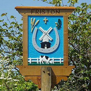
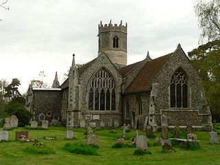
Friston is a village and civil parish in the East Suffolk district, in the county of Suffolk, England. It is 3 miles (5 km) southeast of Saxmundham, its post town, and 4 miles (6 km) northwest of Aldeburgh. The River Alde bounds the village on the south. The surrounding land is chiefly arable. The soil becomes partly marshy in the lower grounds. The village is noted for its early nineteenth century post mill. It is located next to the village of Knodishall.

<span class="mw-page-title-main">Farnham, Suffolk</span> Human settlement in England

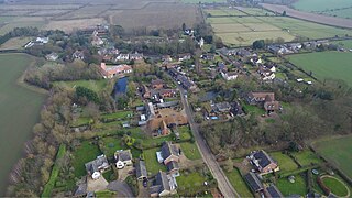
Farnham is a village and civil parish about 3 miles (4.8 km) south-west of Saxmundham in the English county of Suffolk on the A12 road. Farnham is located west of Friday Street, south of Benhall Low Street and north-east of Stratford St Andrew.

<span class="mw-page-title-main">Brandeston</span> Village in Suffolk, England

Brandeston is a village in Suffolk, England on the River Deben 11 miles (18 km) northeast of Ipswich. Brandeston is west of Kettleburgh and northwest of Hoo Green. It is a Parish in Plomesgate district and 3½ miles SW of Framlingham r. station."

<span class="mw-page-title-main">Cotton, Suffolk</span> Human settlement in England

Cotton is a small village and civil parish located in the Mid Suffolk district of Suffolk in eastern England. Cotton lies a few miles to the east of the Great Eastern Main Line and to the west of the A140. Nearby villages include Mendlesham and Bacton, and the parish also includes the small hamlet of Dandy Corner. Its precise location is 4+12 miles north east of its post town, Stowmarket, and 2+12 miles north west of Mendlesham.

<span class="mw-page-title-main">Redlingfield</span> Human settlement in England

Redlingfield is a village and civil parish in the Mid Suffolk district of Suffolk in eastern England. Located around six miles south-east of Diss, in 2011 its population was 144, according to the 2011 census. Redlingfield Priory was found here from 1120 until it was disbanded during the Dissolution of the Monasteries, in which "the priory was surrendered on 10 February 1536-7".

<span class="mw-page-title-main">Withersfield</span> Human settlement in England

Withersfield is a village and civil parish in the West Suffolk district of Suffolk in eastern England. In 2011 its population was 450. It has a public house and a village hall, and centres on the parish church, St. Mary the Virgin. It is in a rural location, surrounded by farmland, yet only a mile north of the busy market town of Haverhill. Surrounding villages include Great Wratting, West Wickham and Great Thurlow.

<span class="mw-page-title-main">Westley, Suffolk</span> Human settlement in England

Westley is a village and civil parish in the West Suffolk district of Suffolk in eastern England. It is located south of Junction 42 of the A14 providing primary access to adjacent market towns Bury St Edmunds (East) and Newmarket (West). The village consists of two central roads: Fornham Lane and Hill Road running north and south through the parish, with adjoining roads accommodating Westley's total population of 183.

<span class="mw-page-title-main">Stansfield</span> Human settlement in England

Stansfield is a village and civil parish in the West Suffolk district of Suffolk in eastern England. Located seven miles south-west of Bury St Edmunds, in 2011 its population was 221. The village has an Anglican church dedicated to All Saints. In 1870, John Marius Wilson's Imperial Gazetteer of England and Wales described Stansfield as

<span class="mw-page-title-main">Walpole, Suffolk</span> Human settlement in England

Walpole is a small village and civil parish in the district of East Suffolk in Suffolk, England. Walpole has a parish church, a redundant chapel, but the primary school has closed. The village is on the River Blyth. Nearby settlements include the town of Halesworth and the village of Cookley. It was in the hundred of Blything. It had a population of 238 according to the 2011 census.

<span class="mw-page-title-main">Shottisham</span> Human settlement in England

Shottisham is a village and civil parish in the East Suffolk district, in the county of Suffolk. It lies in the Wilford Hundred, about four and a half miles south-east of Woodbridge, between the parishes of Sutton, Alderton, Ramsholt and Hollesley, in the Bawdsey peninsula. About three miles from the coast at Hollesley Bay and Shingle Street, the village street overlooks a slight hollow of meads and copses at the road crossing of Shottisham Creek, a tributary brook of the river Deben.

<span class="mw-page-title-main">Sibton</span> Human settlement in England

Sibton is a village and civil parish on the A1120 road, in the East Suffolk district, in the English county of Suffolk. It is near the towns of Saxmundham and Halesworth, the village of Peasenhall and the hamlet of Sibton Green. The church is dedicated to St Peter; there is also the remains of a medieval abbey, Sibton Abbey. There is a large stately house set in the grounds of Sibton Park which dates back 1827 in the Georgian period, which is now used as a hotel. The estate consists of 4500 acres, being part of the Wilderness Reserve where there are holiday cottages and a lake. The Parish is also in close proximity to the River Yox which runs past the White Horse Inn and down through Pouy Street, it then goes on past both the A1120 road and a small wooded area called Abbey Woods to pass through the grounds of Sibton Park and then on to Yoxford.

<span class="mw-page-title-main">Swilland</span> Human settlement in England

Swilland is a village and civil parish, in the East Suffolk district, in the English county of Suffolk. It is north of the large town of Ipswich. Swilland has a church called St Mary's Church and a pub called The Moon & Mushroom Inn which has been awarded Suffolk Pub of The Year on two occasions by the Evening Star. Swilland shares a parish council with Witnesham called "Swilland and Witnesham Grouped Parish Council".

Sutton is a village and a civil parish on the B1083 road, in the East Suffolk district, in the county of Suffolk, England. Sutton has a pub, a mobile post office and a place of worship. There is also the hamlet of Sutton Street and the Sutton Common estate nearby.

<span class="mw-page-title-main">Blyth Rural District</span>

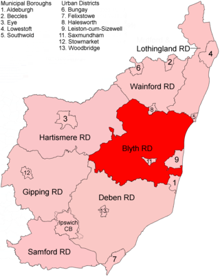
Blyth Rural District was a rural district in East Suffolk, England, between 1934 and 1974.

References

  1. "Parish population 2011" . Retrieved 17 September 2015.
  2. "<Stratford St Andrew>(Parish): Key Figures for 2011 Census: Key Statistics". Neighbourhood Statistics. Office for National Statistics. Retrieved 5 February 2014.
  3. "Key to English Place Names". The University of Nottingham. Retrieved 31 March 2014.
  4. "Place: Stratford [St Andrew]". Open Domesday. Retrieved 23 March 2014.
  5. "Place: Stratford (St Andrew)". Open Domesday. Retrieved 23 March 2014.
  6. Knott, Simon. "History of Stratford St Andrew Church" . Retrieved 20 March 2014.
  7. Wilson, John Marius (1870–72). Imperial Gazetteer of England and Wales (1st ed.). Edinburgh: A. Fullarton & Co. Retrieved 5 February 2014.
  8. "St Mary's Church, Farnham". Farnham with Stratford St Andrew Parish Council. Retrieved 23 March 2014.
  9. Knott, Simon. "History of Stratford St Andrew Church" . Retrieved 23 March 2014.
  10. Knott, Simon. "History of Stratford St Andrew Church" . Retrieved 23 March 2014.
  11. GENUKI. "Stratford St Andrew". GENUKI. Retrieved 21 March 2014.
  12. GENUKI. "Stratford St Andrew". GENUKI. Retrieved 21 March 2014.
  13. "History". Farnham with Stratford St Andrew Parish Council. Retrieved 7 April 2014.
  14. "History". Farnham with Stratford St Andrew Parish Council. Retrieved 7 April 2014.
  15. "History". Farnham with Stratford St Andrew Parish Council. Retrieved 7 April 2014.
  16. "Total Population". A Vision of Britain. Retrieved 24 April 2014.
  17. "Total Houses". Vision of Britain. Retrieved 24 April 2014.
  18. "Key Figures for 2011 Census: Key Statistics". Office for National Statistics. Retrieved 24 April 2014.
  19. "Area". Vision of Britain. Retrieved 24 April 2014.
  20. "1831 Occupations grouped by Status". Vision of Britain. Retrieved 24 April 2014.
  21. "Industry, 2011". Office for National Statistics. Retrieved 24 April 2014.
  22. Knott, Simon. "History of Stratford St Andrew Church" . Retrieved 21 March 2014.
  23. "St Mary's Church, Farnham". Farnham with Stratford St Andrew Parish Council. Retrieved 21 March 2014.
  24. "Village Hall". Farnham with Stratford St Andrew Parish Council. Retrieved 31 March 2014.