Wangford

Last updated

Wangford
Wangfordvillagesign1.jpg
Suffolk UK location map.svg
Red pog.svg
Wangford
Location within Suffolk
Population591 (2011)
OS grid reference TM465795
Civil parish
District
Shire county
Region
Country England
Sovereign state United Kingdom
Post town BECCLES
Postcode district NR34
Dialling code 01502
Police Suffolk
Fire Suffolk
Ambulance East of England
UK Parliament
List of places
UK
England
Suffolk
52°21′18″N1°37′19″E / 52.355°N 1.622°E / 52.355; 1.622

Wangford is a village and former civil parish, now in the parish of Wangford with Henham, in the East Suffolk district, in the county of Suffolk, England, just off the A12 trunk road on the edge of the Henham Park estate just outside Southwold.

Contents

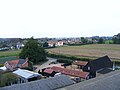
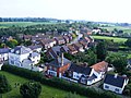
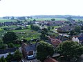
Wangford is connected to the rest of Suffolk by two main roads. At one side of the village the road leads straight on to the A12 (dual carriage way), and the other side of the village leads to Reydon, and Southwold (B1126).

In 1961 the civil parish had a population of 427. [1] On 1 April 1987 the parish was merged with Henham to form "Wangford with Henham". [2] Wangford with Henham has approximately 640 residents, [3] reducing to 591 at the 2011 Census. [4] and the main village covers about 50 acres (200,000 m2).

At the centre of the village there is a community centre, containing a reasonable sized hall, a bar, a kitchen and a small games room. There is also a shop, a pub - the Angel Inn, a farm shop, a playing field and allotments, tennis courts and the local vet.

History

At the dissolution of the monasteries, Wangford Priory was granted to Thomas Howard, 3rd Duke of Norfolk. [5]

The church of St Peter and St Paul

St Peter and St Paul's Church, Wangford Wangfordchurch.jpg
St Peter and St Paul's Church, Wangford

The Parish church of Wangford cum Henham is dedicated to St Peter and St Paul; situated near the centre of the village. The church here was near derelict by the mid-19th century. It was all that survived of a Cluniac Priory, a cell to the mother Priory at Thetford in Norfolk. Left derelict at the end of the 19th century, it was restored by the local Rous family, the Earls of Stradbroke who set about creating a monument to themselves here because there is no church in the parish of Henham. The architect was A. L. Blackburne. All was demolished except for the nave walls. A grand chancel was then built at the east end, and beside it in the 1870s, an impressive tower. The top of the tower is finished in the 14th-century Suffolk manner. It sits at the east end of the north aisle. Inside, the west end of the nave has a huge window, which may possibly be the rebuilding of a previous tower arch. The north porch is the only other medieval survival which seems to have had a side sliced off it by the buttress to the north aisle. As the church is principally 19th century, so is all the stained glass. [6] [7] [8]

Wangford Church at night SS Peter and Paul's Church at night, in Wangford, Suffolk, England.jpg
Wangford Church at night

Angels look down from the simple but effective roof. The lectern is made of brass, and the column is surrounded by angels about to take flight. The pulpit is 17th century and was brought here from the chapel at Henham Hall along with the reading desk. The font is 14th century but with a later cover. The walls are covered with memorials to the Rouses. The building is currently suffering from water damage but fundraising is continuing with the aim of reroofing. The Parish of Wangford is part of the Sole Bay Team Ministry (formed in 1999), along with the Parishes of Blythburgh, Reydon, Sotherton, South Cove, Southwold, Uggeshall and Walberswick. [7] [8]

The church bells of St Peter and St Paul

Wangford church has an unringable peal of five bells. Originally the bells were intended for change ringing. The bells hang in a derelict timber frame with dilapidated fittings and have not been rung for many years. The treble (the smallest) is the oldest bell in the tower, being cast by William Brend of Norwich in 1624. The following year, in 1625, the tenor (the largest) was cast at the same foundry by William & Alice Brend. The third was cast by John Darbie of Ipswich in 1668 and the fourth dates from 1721 and is by John Stephens of Norwich. The newest bell in the tower is the second which was cast by John Warner & Sons of London in 1863. This bell was recast from the metal of an earlier bell also cast by John Stephens. The precise weight of the bells is not known but the tenor is estimated to weigh between 8 and 9 hundredweight. [9]

Famous people and connections

Reputedly, Wangford provided the inspiration for the stage name of Sam Hutt, a well-known London gynaecologist, who specialises in spoof Country and Western music. The chosen name being 'Hank Wangford'. Fred Copeman OBE, who served in the International Brigades in the Spanish Civil War and organised London's air raid defences during the Second World War, was born in Wangford Union Workhouse in 1907.

The annual Latitude Festival is held at Henham Hall Park nearby.

Photos

See also

Related Research Articles

<span class="mw-page-title-main">Southwold</span> Coastal resort in Suffolk, England

Southwold is a seaside town and civil parish on the English North Sea coast in the East Suffolk district of Suffolk. It lies at the mouth of the River Blyth within the Suffolk Coast and Heaths Area of Outstanding Natural Beauty. The town is about 11 miles (18 km) south of Lowestoft, 29 miles (47 km) north-east of Ipswich and 97 miles (156 km) north-east of London, within the parliamentary constituency of Suffolk Coastal. The 2011 Census figure gave a total population of 1,098 for the town, but by the 2021 Census, this had reduced to 950.

<span class="mw-page-title-main">Herringfleet</span> Human settlement in England

Herringfleet is a place and former civil parish, now in the parish of Somerleyton, Ashby and Herringfleet, in the East Suffolk district, in the north of the English county of Suffolk. It is located 5.5 miles (8.9 km) north-west of Lowestoft. The parish was combined with Somerleyton and Ashby to create the parish of "Somerleyton, Ashby and Herringfleet" on 1 April 1987.

<span class="mw-page-title-main">Reydon</span> Human settlement in England

Reydon is a village and civil parish, 1.0 mile (1.6 km) north-west of Southwold and 2.5 miles (4.0 km) south-east of Wangford, in the East Suffolk district and the ceremonial county of Suffolk, England. Its population of 2,567 in 2001 including Easton Bavents eased up to 2,582 at the 2011 Census, and was estimated at 2,772 in 2018. The name probably means Rye Hill, Rey meaning rye and -don being an old word for hill or rise). The village is close to the cliffs at Easton Bavents, a village now much eroded. Both were established before neighbouring Southwold. The parish church is St Margaret of Antioch. The parish of Easton Bavents was merged with Reydon in 1987, when part of Southwold was also transferred.

<span class="mw-page-title-main">Wrentham, Suffolk</span> Rural village in Suffolk, England

Wrentham is a village and civil parish in the East Suffolk district, in the north-east of the English county of Suffolk. It is located about 2 miles (3.2 km) from the North Sea coast on the A12 trunk road, about 7 miles (11 km) south-west of Lowestoft, 4 miles (6.4 km) north of Southwold and 6 miles (9.7 km) south-east of Beccles.

<span class="mw-page-title-main">Blythburgh</span> Human settlement in England

Blythburgh is a village and civil parish in the East Suffolk district of the English county of Suffolk. It is 4 miles (6.4 km) west of Southwold and 5 miles (8.0 km) south-east of Halesworth and lies on the River Blyth. The A12 road runs through the village which is split either side of the road. At the 2011 census the population of the parish was 297. The parish includes the hamlets of Bulcamp and Hinton.

<span class="mw-page-title-main">Easton Bavents</span> Coastal hamlet in Suffolk, England

Easton Bavents is a hamlet and former civil parish, now in the parish of Reydon, in the East Suffolk district of the county of Suffolk, England. Once an important village with a market, it has been much eroded by the North Sea. A map of Suffolk dating from about 1610 shows it to have been the most easterly ecclesiastical parish in England. It is now confined to a stretch of the Suffolk coast to the east of Reydon. In 1961 the parish had a population of 23.

<span class="mw-page-title-main">Frostenden</span> Human settlement in England

Frostenden is a village and civil parish in the East Suffolk district of the English county of Suffolk. It is around 8 miles (13 km) south-west of Lowestoft and 3.5 miles (5.6 km) north-west of Southwold and lies on the A12 road between Wrentham and Wangford. Neighbouring parishes include Wrentham, Sotterley, Uggeshall, Wangford with Henham, Reydon and South Cove.

<span class="mw-page-title-main">A145 road</span> Road in Suffolk, England

The A145 is an A road in the English county of Suffolk. It runs from east of the town of Beccles, close to the border with Norfolk, to the village of Blythburgh where it joins the A12 road. It is around 11 miles (18 km) in length and single carriageway throughout.

<span class="mw-page-title-main">Sotherton</span> Human settlement in England

Sotherton is a dispersed village and civil parish in the East Suffolk district, in the English county of Suffolk. It is located approximately 7 miles (11 km) south of Beccles and 3+34 miles (6.0 km) north-east of Halesworth. The A145 road passes through the east of the parish area. The mid-2005 population estimate for Sotherton parish was 80. Uggeshall is located just to the north-east, Byford to the south and Blythburgh to the south-east. Latitude Festival takes place a couple of miles east.

<span class="mw-page-title-main">Wangford Priory</span>

The Cluniac Priory of Wangford was a small religious house in Wangford in the English county of Suffolk. It was founded before 1159 as a dependency of Thetford Priory. In 1376, it was naturalised before being dissolved in 1540.

<span class="mw-page-title-main">Dunwich</span> Farm village in Suffolk, England

Dunwich is a village and civil parish in Suffolk, England. It is in the Suffolk Coast and Heaths AONB around 92 miles (148 km) north-east of London, 9 miles (14 km) south of Southwold and 7 miles (11 km) north of Leiston, on the North Sea coast.

<span class="mw-page-title-main">South Cove, Suffolk</span> Human settlement in England

South Cove is a civil parish in the east of the English county of Suffolk. It is 3 miles (4.8 km) north of the coastal town of Southwold and 1 mile (1.6 km) south of the village of Wrentham in the East Suffolk district. Neighbouring parishes include Covehithe, Frostenden and Reydon as well as Wrentham. The village lies to the east of the main A12 road, on the B1127 road between Wrentham and Southwold, and is around 1+12 miles (2.4 km) from the North Sea coast.

<span class="mw-page-title-main">A1095 road</span> Road in Suffolk, England

The A1095 road is an A road in the English county of Suffolk. It runs from Southwold on the North Sea coast to the A12 London to Lowestoft road at Henham between Blythburgh and Wangford. It is around 4 miles (6.4 km) in length and is single carriageway throughout. The entire length of the road lies within the Suffolk Coast and Heaths Area of Outstanding Natural Beauty.

<span class="mw-page-title-main">St Edmund's Church, Southwold</span> Church in Southwold, England

St Edmund's Church, Southwold is a Grade I listed parish church in the Church of England in Southwold, Suffolk.

<span class="mw-page-title-main">St Cross South Elmham</span> Human settlement in England

St Cross South Elmham is a village and civil parish in the north of the English county of Suffolk. It is in the East Suffolk district, close to the border with Norfolk and is 3 miles (4.8 km) east of Harleston and 4.25 miles (6.84 km) south-west of Bungay. It is one of the villages around Bungay known as the Saints.

<span class="mw-page-title-main">Holy Trinity Church, Blythburgh</span> Church in Blythburgh, England

The Holy Trinity Church is the parish church of the village of Blythburgh in the East Suffolk district, in the county of Suffolk, England. It is part of the Church of England Halesworth deanery in the diocese of St Edmundsbury and Ipswich, and has been listed Grade I on the National Heritage List for England since December 1966.

<span class="mw-page-title-main">St Andrew's Church, Walberswick</span> Church in Walberswick, England

St Andrew's Church is a Grade I listed building in Walberswick, Suffolk. It is an active parish church in the Church of England.

<span class="mw-page-title-main">Wangford with Henham</span> Human settlement in England

Wangford with Henham is a civil parish in the East Suffolk district of the English county of Suffolk. It is around 5.5 miles (8.9 km) east of Halesworth, 3 miles (4.8 km) north-west of Southwold and 8.5 miles (13.7 km) south of Beccles. The parish includes the village of Wangford, the hamlet of Barnaby Green and Henham Park, the site of the Latitude Festival and a variety of other events. The Henham estate, owned by the Rous family, later the Earls of Stradbroke, owned much of the land in the parish and were responsible for many of the buildings in the area.

<span class="mw-page-title-main">Grand Henham Steam Rally</span>

The Grand Henham Steam Rally is a steam rally held every September at Henham Park near Southwold. It features displays of fixed and mobile steam engines and of vintage and classic cars and motorcycles. There are many events and activities, and craft, trade and food stalls. Proceeds are given to local charities. The organiser was forced into liquidation in July 2020.

<span class="mw-page-title-main">Henham, Suffolk</span> Human settlement in England

Henham is a former civil parish now in the parish of Wangford with Henham, in the East Suffolk district, in the county of Suffolk, England. In 1961 the parish had a population of 90. The majority of the parish was covered by Henham Park.

References

  1. "Population Statistics Wangford CP/AP through time". Vision of Britain. Retrieved 28 February 2018.
  2. "The Waveney (Parishes) Order 1987" (PDF). Local Government Boundary Commission for England . Retrieved 25 January 2020.
  3. Taken from ESTIMATES OF TOTAL POPULATION OF AREAS IN SUFFOLK Archived 19 December 2008 at the Wayback Machine . 2 August 2009. Page 17.
  4. "Civil Parish population 2011" . Retrieved 19 September 2015.
  5. John Kirby (1764). The Suffolk Traveller. London: J. Shave.
  6. Taken from The Sole Bay Team Ministry. 27 January 2009.
  7. 1 2 Taken from The Suffolk Churches Site. 27 January 2009.
  8. 1 2 Taken from 'A photographic and historical guide to the Parish Churches of East Suffolk' compiled by Adrian S. Pye. 27 January 2009. Page 272
  9. Taken from Doves Guide. 27 January 2009.