
Bradwell is a village and civil parish in the English county of Norfolk. The village is immediately to the west of, and largely indistinguishable from, the built-up urban area of the town of Great Yarmouth.

Acton is a village and civil parish in the English county of Suffolk. The parish also includes the hamlets of Cuckoo Tye and Newman's Green.
Athelington is a small village and civil parish in the Mid Suffolk district of Suffolk, England, about 12 miles (19 km) south-east from Diss. The name is derived from the Old English word Ætheling. The population of the village was less than 50 at the 2011 Census and is included in the civil parish of Redlingfield, in 2005 the population was estimated as 30.

Burgh is a village and civil parish in the East Suffolk district of Suffolk, England, about 3.5 miles (6 km) north-west of Woodbridge.

Bracon Ash is a village and civil parish in the South Norfolk district of the English county of Norfolk.

Fritton is a village and former civil parish in county of Norfolk, England. The village is located 6 miles (9.7 km) south-west of Great Yarmouth and 16 miles (26 km) south-east of Norwich, along the A143 between Gorleston-on-Sea and Haverhill. In 1961 the parish had a population of 192.

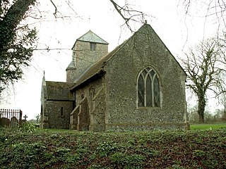
Little Bradley is a small village and civil parish in the West Suffolk district, in the county of Suffolk, England. According to Eilert Ekwall, the meaning of the village name is "the wide clearing." The Domesday Book records the population of Little Bradley in 1086 to be 57. It lies in the valley of the River Stour, north of Haverhill. The population at the 2011 Census was included in the civil parish of Great Bradley.

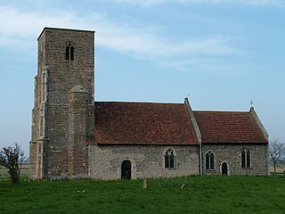
Chattisham is a village and civil parish in Suffolk, England. Located around two miles west of Ipswich and half a mile south of the A1071, it is part of Babergh district. In 2006 its population was 140, increasing to 167 at the 2011 Census. It is in the Belstead Brook electoral division of Suffolk County Council. In the early 1870s, Chattisham was portrayed as: "CHATTISHAM, a parish in Samford district, Suffolk; 2¼ miles NE of Raydon r. station, and 5 SW by W of Ipswich. Post town, Ipswich. Acres, 713. Real property, £1, 427. Pop., 192. Houses, 47. The property is divided among a few. The living is a vicarage in the Diocese of Norwich. Value, £168.* Patron, Eton College. The church has a brass of 1592; and is good. There are a Wesleyan chapel, and charities £6."

Hollesley is a village and civil parish in the East Suffolk district of Suffolk east of Ipswich in eastern England. Located on the Bawdsey peninsula five miles south-east of Woodbridge, in 2005 it had a population of 1,400 increasing to 1,581 at the 2011 Census.

Thorndon is a village and civil parish in the Mid Suffolk district of Suffolk in eastern England. The village is located around three miles south of Eye, close to the A140. It is located 92 miles northeast of London. In 2011, the population was 648, as recorded by the 2011 census. Village facilities include All Saints' Church and a local primary school.
Gillingham is a small village and civil parish in the English county of Norfolk. The villages is located 1.5 miles (2.4 km) north-west of Beccles and 15 miles (24 km) south-east of Norwich, along the A146 between Norwich and Lowestoft.

Fornham All Saints is a village and civil parish in Suffolk, England in the West Suffolk district. It is north-northwest of the town of Bury St Edmunds and 500m west of Fornham St Genevieve. Fornham All Saints is one of a trio of contiguous villages by the River Lark. The other villages are Fornham St Genevieve and Fornham St Martin.

Rivenhall is a village and civil parish near Witham in the Braintree district in the English county of Essex. It is near the small settlement of Rivenhall End. In 2021 the parish had a population of 1147.

Waldringfield is a village and civil parish in the East Suffolk district, in the county of Suffolk, England. It is situated on the bank of the River Deben within the Suffolk Coast and Heaths Area of Outstanding Natural Beauty, 4 miles (6.4 km) south of the town of Woodbridge and 8 miles (12.9 km) east of the county town of Ipswich.

Newbourne is a village and civil parish in the East Suffolk district of Suffolk, England. It lies on the peninsula between the River Orwell and the River Deben, to the east of Ipswich and south of Woodbridge.
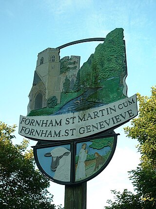
Fornham St Genevieve is a village and civil parish in the West Suffolk district of Suffolk in eastern England. It is one of a trio of contiguous villages by the River Lark. The other villages are Fornham All Saints and Fornham St Martin.

Falkenham is a village and a civil parish in the East Suffolk district, in the English county of Suffolk, near the village of Kirton and the towns of Ipswich and Felixstowe. The population of the civil parish as of the 2011 census was 170.
Chediston is a village and a civil parish on the B1123 road, in the East Suffolk district, in the English county of Suffolk. It is located 2 miles west of Halesworth, its post town. The population of the civil parish as of the 2011 census was 195 and in 2018 it was estimated to be 234.

Sandon is a village and civil parish in the North Hertfordshire district, in the county of Hertfordshire, England. Sandon is located near the towns of Baldock and Buntingford. The parish also includes the hamlets of Green End and Roe Green, and Blagrove Common, a nature reserve. At the 2011 Census the population of the civil parish was 495.
Wantisden is a small village and civil parish in the East Suffolk district of Suffolk in eastern England. Largely consisting of a single farm and ancient woodland, most of its 30 residents live on the farm estate. It shares a parish council with nearby Butley and Capel St. Andrew. It has a church dedicated to St John the Baptist.

