
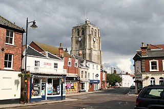
Southwold is a seaside town and civil parish on the North Sea, in the East Suffolk district, in the county of Suffolk, England. It lies at the mouth of the River Blyth in the Suffolk Coast and Heaths Area of Outstanding Natural Beauty, 11 miles (18 km) south of Lowestoft, 29 miles (47 km) north-east of Ipswich and 97 miles (156 km) north-east of London, within the parliamentary constituency of Suffolk Coastal. At the 2021 Census, the population was 950.
Beccles is a market town and civil parish in the East Suffolk district, in the county of Suffolk, England. The town on the A145 and A12 roads, situated 16 miles (26 km) south-east of Norwich and 33 miles (53 km) north-northeast of Ipswich. Nearby towns include Lowestoft to the east and Great Yarmouth to the north-east. The town lies on the River Waveney on the edge of The Broads National Park.

East Suffolk, along with West Suffolk, was created in 1888 as an administrative county of England. The administrative county was based on the eastern quarter sessions division of Suffolk. East Suffolk County Council's headquarters were at East Suffolk County Hall in Ipswich.

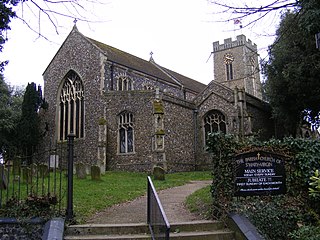
Reydon is a village and civil parish, 1.0 mile (1.6 km) north-west of Southwold and 2.5 miles (4.0 km) south-east of Wangford, in the East Suffolk district and the ceremonial county of Suffolk, England. Its population of 2,567 in 2001 including Easton Bavents eased up to 2,582 at the 2011 Census, and was estimated at 2,772 in 2018. The name probably means Rye Hill, Rey meaning rye and -don being an old word for hill or rise). The village is close to the cliffs at Easton Bavents, a village now much eroded. Both were established before neighbouring Southwold. The parish church is St Margaret of Antioch. The parish of Easton Bavents was merged with Reydon in 1987, when part of Southwold was also transferred.
Halesworth is a market town, civil parish and electoral ward in north-eastern Suffolk, England. The population stood at 4,726 in the 2011 Census. It lies 15 miles (24 km) south-west of Lowestoft, on a tributary of the River Blyth, nine miles upstream from Southwold. The town is served by Halesworth railway station on the Ipswich–Lowestoft East Suffolk Line. It is twinned with Bouchain in France and Eitorf in Germany. Nearby villages include Cratfield, Wissett, Chediston, Walpole, Blyford, Linstead Parva, Wenhaston, Thorington, Spexhall, Bramfield, Huntingfield, Cookley and Holton.

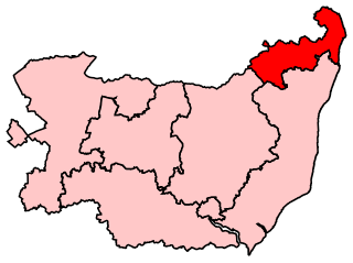
Suffolk Coastal is a parliamentary constituency in the county of Suffolk, England, which has been represented in the House of Commons of the UK Parliament since 2024 by Jenny Riddell-Carpenter, a Labour Party Member of Parliament (MP).
Waveney was a constituency of in the House of Commons of the UK Parliament that existed from 1983 to 2024. It returned one Member of Parliament (MP) to the House of Commons of the Parliament of the United Kingdom.

Brampton is a village and former civil parish, now in the parish of Brampton with Stoven, in the East Suffolk district, in the county of Suffolk, England. It is around 4 miles (6.4 km) north-east of Halesworth, 5 miles (8.0 km) south of Beccles and 5 miles (8.0 km) north-west of Southwold. In 1961 the parish had a population of 306. On 1 April 1987, the parish was merged with Stoven to form "Brampton with Stoven" parish and the mid-2005 population estimate for the expanded parish was 460.
Barnby is a village and civil parish in the East Suffolk district of Suffolk, England. The village is 5 miles (8.0 km) west of Lowestoft and 3 miles (4.8 km) east of Beccles in the north of the county. It is effectively merged with the village of North Cove which constitutes a separate parish.

Lowestoft is a parliamentary constituency centred on the town of Lowestoft in Suffolk. It returns one Member of Parliament (MP) to the House of Commons of the Parliament of the United Kingdom, elected by the first past the post voting system.

Beccles Lido is an open-air pool at Puddingmoor, Beccles, Suffolk, on the banks of the River Waveney.
Local elections were held in Waveney district every four years to elect councillors to Waveney District Council. In the past, one-third of councillors were elected each year, but in 2010 the council opted to change to a whole council election system. Since the last boundary changes in 2002, 48 councillors have been elected from 23 wards. The district was merged with Suffolk Coastal in April 2019 to form East Suffolk, meaning that the 2015 elections were the final Waveney elections to be held.

The A144 is an A road in the English county of Suffolk. It runs from the town of Bungay, close to the border with Norfolk, to the A12 trunk road near the village of Darsham, passing through the market town of Halesworth. It is around 14 miles (23 km) in length and is single carriageway throughout.
The Sunrise Coast is a stretch of tourist coastline in the English county of Suffolk. The area includes the seaside resort towns of Lowestoft and Southwold and the inland Broads towns of Beccles and Bungay within the Waveney district.

Elections to Waveney District Council took place on Thursday 5 May 2011. This was the first election held as a Whole Council election following a change made to the electoral system in 2010. As a result, all 48 council seats were contested.

North Cove is a village and civil parish in the north of the English county of Suffolk. It is part of the East Suffolk district, located around 3 miles (4.8 km) east of Beccles and 5 miles (8.0 km) west of Lowestoft. It merges with the village of Barnby and the villages share some resources, although the two parishes retain separate parish councils.

East Suffolk is a local government district in Suffolk, England. The largest town is Lowestoft, which contains Ness Point, the easternmost point of the United Kingdom. The second largest town is Felixstowe, which has the country's largest container port. On the district's south-western edge it includes parts of the Ipswich built-up area. The rest of the district is largely rural, containing many towns and villages, including several seaside resorts. Its council is based in the village of Melton. The district was formed in 2019 as a merger of the two previous districts of Suffolk Coastal and Waveney. In 2021 it had a population of 246,058. It is the most populous district in the country not to be a unitary authority.

Wangford with Henham is a civil parish in the East Suffolk district of the English county of Suffolk. It is around 5.5 miles (8.9 km) east of Halesworth, 3 miles (4.8 km) north-west of Southwold and 8.5 miles (13.7 km) south of Beccles. The parish includes the village of Wangford, the hamlet of Barnaby Green and Henham Park, the site of the Latitude Festival and a variety of other events. The Henham estate, owned by the Rous family, later the Earls of Stradbroke, owned much of the land in the parish and were responsible for many of the buildings in the area.

Waveney Valley is a constituency of the House of Commons in the UK Parliament, created following the 2023 Periodic Review of Westminster constituencies. Since its first election in 2024, it has been represented by Adrian Ramsay of the Green Party and is the first Green seat in the East of England.

