Mutford and Lothingland Rural District

Last updated

Mutford and Lothingland
Mutford and Lothingland RD 1894.png
Location within East Suffolk, 1894
History
  Created1894
  Abolished1934
  Succeeded by Lothingland Rural District
Status Rural district

Mutford and Lothingland Rural District was a rural district within the administrative county of East Suffolk between 1894 and 1934. It was created out of the earlier Mutford and Lothingland rural sanitary district. [1] It was named after the historic hundred of Mutford and Lothingland, whose boundaries it closely matched.

Contents

In 1904 a new Oulton Broad Urban District was created out of parts of Carlton Colville [2] and Oulton [3] parishes. Oulton Broad UD was absorbed by the Municipal Borough of Lowestoft in 1919.

In 1934, under a County Review Order, Mutford and Lothingland Rural District was abolished and its parishes transferred to the new Lothingland Rural District, apart from Gunton and some part parishes which were added to Lowestoft MB. In 1974 the area was divided between the new districts of Great Yarmouth (in Norfolk) and Waveney in Suffolk.

Statistics

YearArea [4] Population
[5]
Density
(pop/ha)
acresha
191128,17111,40111,1840.98
192111,8651.04
193111,9961.05

Parishes

Mutford and Lothingland RD contained the parishes of Ashby, Barnby, Belton, Blundeston, Bradwell, Burgh Castle, Carlton Colville, Corton, Flixton, Fritton, Gisleham, Gunton, Herringfleet, Hopton on Sea, Kessingland, Lound, Mutford, Oulton, Pakefield, Rushmere and Somerleyton.

Related Research Articles

<span class="mw-page-title-main">Clare Rural District</span>

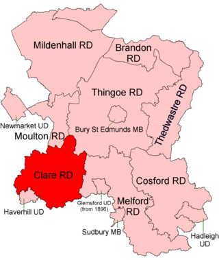
Clare Rural District was a rural district in the county of West Suffolk, England. It was created in 1894, comprising those parishes in the Risbridge rural sanitary district which were in Suffolk.

<span class="mw-page-title-main">Hartismere Rural District</span> Rural district in East Suffolk, England

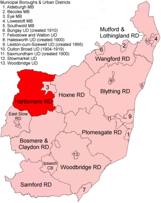
Hartismere Rural District was a rural district in the county of East Suffolk, England. It was expanded in 1934 by merging with the disbanded Hoxne Rural District with a slight readjustment of boundaries. It was named after the ancient Hundred of Hartismere and administered from Eye.

<span class="mw-page-title-main">Melford Rural District</span> Former rural district in West Suffolk, England

Melford Rural District was a rural district in the county of West Suffolk, England. It was created in 1894, under the Local Government Act 1894 from that part of the Sudbury rural sanitary district in West Suffolk. It was named after Long Melford and administered from Sudbury. Shortly after its creation, in 1896, the parish of Glemsford was made a separate urban district.

<span class="mw-page-title-main">Lothingland Rural District</span> Former rural district in East Suffolk, England

Lothingland was a rural district in East Suffolk, England, named after the ancient half-hundred of Lothingland which was merged with Mutford half-hundred in 1763 to form Mutford and Lothingland.

Lothingland is an area in the English counties of Suffolk and Norfolk on the North Sea coast. It is bound by the River Yare and Breydon Water to the north, the River Waveney to the west and Oulton Broad to the south, and includes the parts of Lowestoft north of Lake Lothing.

<span class="mw-page-title-main">East Stow Rural District</span>

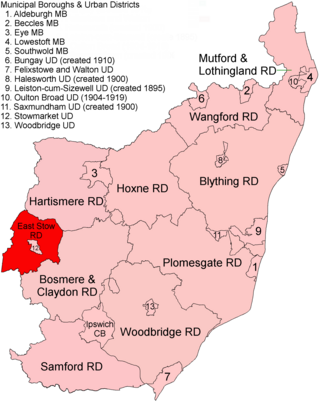
East Stow was a rural district in East Suffolk, England from 1894 to 1934.

Mutford and Lothingland was a hundred of Suffolk, with an area of 33,368 acres (135.04 km2). Lowestoft Ness, the most easterly point of Great Britain fell within its bounds.

<span class="mw-page-title-main">Downham Rural District</span>

Downham Rural District was a rural district in Norfolk, England from 1894 to 1974.

<span class="mw-page-title-main">Marshland Rural District</span>

Marshland Rural District was a rural district in Norfolk, England from 1894 to 1974.

<span class="mw-page-title-main">Moulton Rural District</span> Former rural district in West Suffolk, England

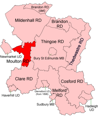
Moulton was a rural district in Suffolk, England from 1894 to 1935. It covered the area to the east of the town of Newmarket.

<span class="mw-page-title-main">Wayland Rural District</span>

Wayland Rural District was a rural district in Norfolk, England from 1894 to 1974.

<span class="mw-page-title-main">Thetford Rural District</span>

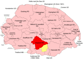
Thetford Rural District was a rural district in Norfolk, England from 1894 to 1935.

<span class="mw-page-title-main">Depwade Rural District</span>

Depwade Rural District was a rural district in Norfolk, England from 1894 to 1974.

<span class="mw-page-title-main">Erpingham Rural District</span>

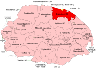
Erpingham Rural District was a rural district in Norfolk, England from 1894 to 1974.

<span class="mw-page-title-main">Brandon Rural District</span> Former rural district in Suffolk, England

Brandon was a rural district in Suffolk, England from 1894 to 1935. The district was created in 1894 as the Suffolk part of the Thetford rural sanitary district, the Norfolk part becoming Thetford Rural District. This left the westernmost parishes of Brandon and Santon Downham detached from the rest of the district.

<span class="mw-page-title-main">Blything Rural District</span>

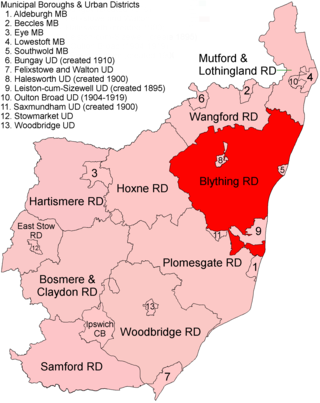
Blything Rural District was a rural district within the administrative county of East Suffolk between 1894 and 1934.

<span class="mw-page-title-main">Hoxne Rural District</span>

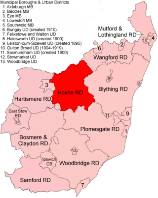
Hoxne Rural District was a rural district within the administrative county of East Suffolk between 1894 and 1934. It was created out of the earlier Hoxne rural sanitary district. It was named after the historic hundred of Hoxne, whose boundaries it closely matched. The hundred, in turn, took its name from the village of Hoxne.

<span class="mw-page-title-main">Plomesgate Rural District</span> Former rural district in West Suffolk, England

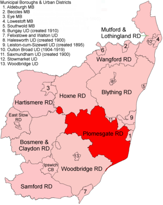
Plomesgate Rural District was a rural district within the administrative county of East Suffolk between 1894 and 1934.

<span class="mw-page-title-main">Wangford Rural District</span> Former rural district in East Suffolk, England

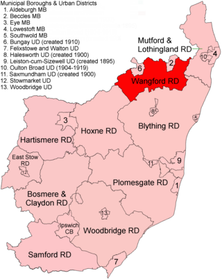
Wangford Rural District was a rural district within the administrative county of East Suffolk between 1894 and 1934. It was created out of the earlier Wangford rural sanitary district. It was named after the historic hundred of Wangford, whose boundaries it closely matched. It contained the group of small villages collectively known as The Saints.

<span class="mw-page-title-main">Blyth Rural District</span>

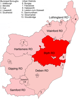
Blyth Rural District was a rural district in East Suffolk, England, between 1934 and 1974.

References

  1. "Mutford and Lothingland RD through time: Census tables with data for the Local Government District". A Vision of Britain through Time. GB Historical GIS / University of Portsmouth. Retrieved 10 July 2017.
  2. "Carlton Colville CP/AP through time: Census tables with data for the Local Government District". A Vision of Britain through Time. GB Historical GIS / University of Portsmouth. Retrieved 10 July 2017.
  3. "Oulton CP/AP through time: Census tables with data for the Local Government District". A Vision of Britain through Time. GB Historical GIS / University of Portsmouth. Retrieved 10 July 2017.
  4. "Mutford and Lothingland RD through time: Population Statistics: Area (acres)". A Vision of Britain through Time. GB Historical GIS / University of Portsmouth. Retrieved 10 July 2017.
  5. "Mutford and Lothingland RD through time: Population Statistics: Total Population". A Vision of Britain through Time. GB Historical GIS / University of Portsmouth. Retrieved 10 July 2017.
52°30′N1°42′E / 52.50°N 1.70°E / 52.50; 1.70