Plomesgate Rural District

Last updated

Plomesgate
Plomesgate RD 1894.png
Location within East Suffolk, 1894
History
  Created28 December 1894
  Abolished31 March 1934
  Succeeded by Blyth Rural District and Deben Rural District
Status Rural district
   HQ Plomesgate House, Chapel Lane, Wickham Market

Plomesgate Rural District was a rural district within the administrative county of East Suffolk between 1894 and 1934.

Contents

History

The district had its origins in the Plomesgate Poor Law Union, which had been created in 1835. It was named after the historic hundred of Plomesgate, although it covered a significantly larger area that included most, but not all, of the historic hundred. A workhouse was built to serve the poor law union in 18361837 on Chapel Lane in Wickham Market. [1] In 1872, sanitary districts were established, with responsibility for public health and local government given to the boards of guardians of poor law unions for areas without urban authorities. The Plomesgate Rural Sanitary District initially covered the same area as the Plomesgate Poor Law Union, but in 1885 the town of Aldeburgh became a municipal borough and thereafter formed its own urban sanitary district. [2]

Under the Local Government Act 1894, rural sanitary districts became rural districts on 28 December 1894. Plomesgate Rural District Council held its first meeting on 31 December 1894 at the Plomesgate Union Workhouse (later known as Plomesgate House) in Wickham Market. George Walker, the previous chairman of the board of guardians, was appointed the first chairman of the council. [3] Plomesgate House served as the council's meeting place throughout the period the council existed. [4]

In 1900 the parish of Saxmundham was made an urban district, removing it from the Plomesgate Rural District. [5]

In 1934, under a County Review Order, Plomesgate Rural District was abolished and most of its parishes transferred to the new Blyth and Deben Rural Districts. The parish of Kenton, which was detached from the rest of the Plomesgate Rural District, became part of Hartismere Rural District. The parish of Hazlewood was abolished at the same time, being split between the parish of Friston (which went to Blyth Rural District) and the borough of Aldeburgh.

Statistics

YearArea [6] Population
[7]
Density
(pop/ha)
acresha
191172,62929,39215,7080.53
192114,9400.51
193113,9670.48

Parishes

Plomesgate Rural District comprised the following civil parishes: [8]

ParishFromToSubsequent districtNotes
Benhall 28 Dec 189431 Mar 1934Blyth RD
Blaxhall 28 Dec 189431 Mar 1934Deben RD
Brandeston 28 Dec 189431 Mar 1934Blyth RD
Bruisyard 28 Dec 189431 Mar 1934Blyth RD
Butley 28 Dec 189431 Mar 1934Deben RD
Campsey Ash 28 Dec 189431 Mar 1934Deben RD
Chillesford 28 Dec 189431 Mar 1934Deben RD
Cransford 28 Dec 189431 Mar 1934Blyth RD
Cretingham 28 Dec 189431 Mar 1934Deben RD
Earl Soham 28 Dec 189431 Mar 1934Blyth RD
Easton 28 Dec 189431 Mar 1934Blyth RD
Eyke 28 Dec 189431 Mar 1934Deben RD
Farnham 28 Dec 189431 Mar 1934Blyth RD
Framlingham 28 Dec 189431 Mar 1934Blyth RD
Friston 28 Dec 189431 Mar 1934Blyth RD
Gedgrave 28 Dec 189431 Mar 1934Deben RD
Great Glemham 28 Dec 189431 Mar 1934Blyth RD
Hacheston 28 Dec 189431 Mar 1934Blyth RD
Havergate Island 28 Dec 189431 Mar 1934Deben RD
Hazlewood 28 Dec 189431 Mar 1934abolishedParish abolished same time as Plomesgate Rural District, being split between Aldeburgh Municipal Borough and Friston parish in Blyth Rural District.
Hoo 28 Dec 189431 Mar 1934Deben RD
Iken 28 Dec 189431 Mar 1934Deben RD
Kenton 28 Dec 189431 Mar 1934Hartismere RD
Kettleburgh 28 Dec 189431 Mar 1934Blyth RD
Letheringham 28 Dec 189431 Mar 1934Deben RD
Little Glemham 28 Dec 189431 Mar 1934Blyth RD
Marlesford 28 Dec 189431 Mar 1934Blyth RD
Monewden 28 Dec 189431 Mar 1934Deben RD
Orford 28 Dec 189431 Mar 1934Deben RD
Parham 28 Dec 189431 Mar 1934Blyth RD
Rendham 28 Dec 189431 Mar 1934Blyth RD
Rendlesham 28 Dec 189431 Mar 1934Deben RD
Saxmundham 28 Dec 189430 Sep 1900Saxmundham UDBecame an urban district on 1 October 1900. [9]
Snape 28 Dec 189431 Mar 1934Blyth RD
Sternfield 28 Dec 189431 Mar 1934Blyth RD
Stratford St Andrew 28 Dec 189431 Mar 1934Blyth RD
Sudbourne 28 Dec 189431 Mar 1934Deben RD
Swefling 28 Dec 189431 Mar 1934Blyth RD
Tunstall 28 Dec 189431 Mar 1934Deben RD
Wantisden 28 Dec 189431 Mar 1934Deben RD
Wickham Market 28 Dec 189431 Mar 1934Deben RD

Related Research Articles

Wing Rural District was a rural district in the administrative county of Buckinghamshire, England. It was created in 1894 with the name Linslade Rural District, but was renamed Wing Rural District in 1897 when Linslade itself was removed from the district to become an urban district. Wing Rural District was abolished in 1974 to become part of Aylesbury Vale District.

Winslow Rural District was a rural district in the administrative county of Buckinghamshire, England from 1894 to 1974, covering an area in the north of the county.

<span class="mw-page-title-main">Potters Bar Urban District</span>

Potters Bar Urban District was a local government district in England from 1894 to 1974, covering the town of Potters Bar and the village of South Mimms. The district was initially called the South Mimms Rural District, being renamed in 1934.

Wycombe Rural District was, from 1894 to 1974, a rural district in the administrative county of Buckinghamshire, England.

<span class="mw-page-title-main">South Westmorland Rural District</span>

South Westmorland was a rural district in Westmorland, England from 1894 to 1974. It saw various boundary changes during its existence, particularly in 1935, when it absorbed Kirkby Lonsdale urban district, whilst parts merged with Ambleside and Grasmere Urban Districts to form Lakes Urban District at the same time. The district was abolished in 1974 under the Local Government Act 1972, with the area becoming part of the South Lakeland district of Cumbria.

<span class="mw-page-title-main">Ely Rural District</span>

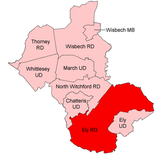
Ely Rural District was a rural district in England from 1894 to 1974. It was named after Ely, but did not include the city itself, instead covering the rural area to the west and north of it. It formed part of the administrative county of the Isle of Ely from 1894 to 1965, when this was merged into Cambridgeshire and Isle of Ely.

East Elloe was a rural district in Holland in Lincolnshire from 1894 to 1974.

Long Crendon was a rural district in the administrative county of Buckinghamshire, England from 1894 to 1934.

Eaton Socon was a rural district in Bedfordshire, England from 1894 to 1934.

<span class="mw-page-title-main">Hambleden Rural District</span> Historical rural district

Hambleden Rural District was a rural district in Buckinghamshire, England from 1894 to 1934, covering an area in the south-west of the county.

St Albans Rural District was a rural district in the administrative county of Hertfordshire, England from 1894 to 1974. It surrounded but did not include the city of St Albans.

Kington Rural District was a rural district in the administrative county of Herefordshire, England from 1894 to 1974, covering an area in the west of the county.

<span class="mw-page-title-main">Blything Rural District</span>

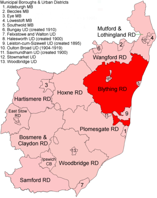
Blything Rural District was a rural district within the administrative county of East Suffolk between 1894 and 1934.

<span class="mw-page-title-main">Blyth Rural District</span>

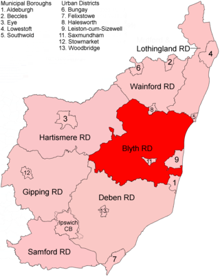
Blyth Rural District was a rural district in East Suffolk, England, between 1934 and 1974.

<span class="mw-page-title-main">Garstang Rural District</span> Historical rural district in Lancashire

Garstang Rural District was a rural district in the county of Lancashire, England from 1894 to 1974.

Woburn was a rural district in Bedfordshire, England from 1894 to 1900, covering Woburn and surrounding parishes.

Chipping Norton Rural District was a rural district in Oxfordshire, England from 1894 to 1974. It surrounded but did not include the town of Chipping Norton.

Witney Rural District was a rural district in Oxfordshire, England from 1894 to 1974. It surrounded but did not include the town of Witney.

Haverfordwest Rural District was a rural district in the administrative county of Pembrokeshire, Wales from 1894 to 1974, covering an area in the west of the county. It surrounded, but did not include, the town of Haverfordwest after which it was named.

Pembroke Rural District was a rural district in the administrative county of Pembrokeshire, Wales from 1894 to 1974, covering an area in the south of the county. It surrounded, but did not include, the town of Pembroke after which it was named.

References

  1. Higginbotham, Peter. "Plomesgate Workhouse". The Workhouse. Retrieved 12 March 2022.
  2. "Plomesgate Rural Sanitary District". A Vision of Britain through Time. GB Historical GIS / University of Portsmouth. Retrieved 12 March 2022.
  3. "Plomesgate". East Anglian Daily Times. Ipswich. 1 January 1895. p. 7. Retrieved 12 March 2022.
  4. "Closing meeting of Plomesgate Rural Council". Diss Express. 16 March 1934. p. 5. Retrieved 12 March 2022.
  5. "Saxmundham CP/AP through time: Census tables with data for the Local Government District". A Vision of Britain through Time. GB Historical GIS / University of Portsmouth. Retrieved 10 July 2017.
  6. "Plomesgate RD through time: Population Statistics: Area (acres)". A Vision of Britain through Time. GB Historical GIS / University of Portsmouth. Retrieved 10 July 2017.
  7. "Plomesgate RD through time: Population Statistics: Total Population". A Vision of Britain through Time. GB Historical GIS / University of Portsmouth. Retrieved 10 July 2017.
  8. "Plomesgate Rural District". A Vision of Britain through Time. GB Historical GIS / University of Portsmouth. Retrieved 12 March 2022.
  9. Annual Report of the Local Government Board. London: His Majesty's Stationery Office. 1901. p. 345. Retrieved 12 March 2022.
52°10′N1°25′E / 52.17°N 1.42°E / 52.17; 1.42