Forest Heath District

Last updated

Forest Heath
Forest Heath District
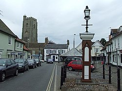
Marketplace Mildenhall - geograph.org.uk - 822218.jpg
Mildenhall
Forest Heath UK locator map.svg
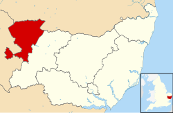
Forest Heath shown within Suffolk
Sovereign state United Kingdom
Constituent country England
Region East of England
Non-metropolitan county Suffolk
Status Non-metropolitan district
Admin HQ Mildenhall
Incorporated1 April 1974
Abolished31 March 2019
Government
  TypeNon-metropolitan district council
  BodyForest Heath District Council
  Leadership Alternative - Sec.31 ( )
   MPs Matthew Hancock
Area
  Total145.8 sq mi (377.7 km2)
Population
 (mid-2018)
  Total65,500
  Density450/sq mi (170/km2)
  Ethnicity
91.0% White
3.0% Black
1.3% S.Asian
3.1% mixed race
Time zone UTC0 (GMT)
  Summer (DST) UTC+1 (BST)
ONS code 42UC (ONS)
E07000201 (GSS)
OS grid reference TL7156375032
Website www.westsuffolk.gov.uk

Forest Heath was a local government district in Suffolk, England. Its council was based in Mildenhall. Other towns in the district included Newmarket. The population of the district at the 2011 Census was 59,748. [1]

Contents

The district's name reflected the fact that it contains parts of both Thetford Forest and the heathlands of Breckland. The district was formed on 1 April 1974, under the Local Government Act 1972, by a merger of Newmarket Urban District and Mildenhall Rural District. Forest Heath district was merged with the borough of St Edmundsbury on 1 April 2019 to form a new West Suffolk district. [2]

Forest Heath was the home to two of the largest United States Air Force (USAF) airbases in the UK: RAF Lakenheath and RAF Mildenhall, as well as the headquarters of British horse racing, Newmarket Racecourse.

Forest Heath had had a high suicide rate when compared to the rest of Suffolk, to the East of England and to England overall. [3] [4] The reasons for this are unknown.

In the English indices of deprivation 2010 report published by the Department for Communities and Local Government, two parts of Forest Heath have the highest employment out of 32483 areas in England. [5]

Governance

As of the 2015 Local Government Elections, the Conservatives held overall control of the District Council.

partyseats
Conservative19
West Suffolk Independents5
UKIP3

Communities

The district contains three market towns and twenty civil parishes.

Towns

Civil parishes

Education

The Shi-Tennoji School in UK in Herringswell, Forest Heath was in operation beginning in 1985, [6] and ending on 17 July 2000. [7]

Related Research Articles

<span class="mw-page-title-main">Suffolk</span> County of England

Suffolk is a ceremonial county in the East of England and East Anglia. It is bordered by Norfolk to the north, the North Sea to the east, Essex to the south, and Cambridgeshire to the west. Ipswich is the largest settlement and the county town.

<span class="mw-page-title-main">Newmarket, Suffolk</span> Market town in Suffolk, England

Newmarket is a market town and civil parish in the West Suffolk district of Suffolk, England. Located west of Bury St Edmunds and northeast of Cambridge. It is considered the birthplace and global centre of thoroughbred horse racing. It is a major local business cluster, with annual investment rivalling that of the Cambridge Science Park, the other major cluster in the region. It is the largest racehorse training centre in Britain, the largest racehorse breeding centre in the country, home to most major British horseracing institutions, and a key global centre for horse health. Two Classic races, and an additional three British Champions Series races are held at Newmarket every year. The town has had close royal connections since the time of James I, who built a palace there, and was also a base for Charles I, Charles II, and most monarchs since. Elizabeth II visited the town often to see her horses in training.

<span class="mw-page-title-main">Mildenhall, Suffolk</span> Human settlement in England

Mildenhall is a market town and civil parish in Suffolk, England. The town is near the A11 road, and is 37 mi (60 km) north-west of Ipswich, the county town. The large Royal Air Force station, RAF Mildenhall, as well as RAF Lakenheath, are located north of the town. Both are used by the United States Air Force as the headquarters of its 100th Air Refueling Wing and 352nd Special Operations Group. Mildenhall is often seen as the start of The Fens on the south/east.

<span class="mw-page-title-main">West Suffolk (county)</span> English administrative county (1889–1974)

West Suffolk was an administrative county of England created in 1889 from part of the county of Suffolk. It survived until 1974 when it was rejoined with East Suffolk. Its county town was Bury St Edmunds.

<span class="mw-page-title-main">Lakenheath</span> Human settlement in England

Lakenheath is a village and civil parish in the West Suffolk district of Suffolk in eastern England. It has a population of 4,691 according to the 2011 Census, and is situated close to the county boundaries of both Norfolk and Cambridgeshire, and at the meeting point of The Fens and the Breckland natural environments.

<span class="mw-page-title-main">RAF Mildenhall</span> Royal Air Force station near Mildenhall, Suffolk, United Kingdom

Royal Air Force Mildenhall or more simply RAF Mildenhall is a Royal Air Force station located near Mildenhall in Suffolk, England. Despite its status as a Royal Air Force station, it primarily supports United States Air Force (USAF) operations, and is currently the home of the 100th Air Refueling Wing.

<span class="mw-page-title-main">West Suffolk (UK Parliament constituency)</span> Parliamentary constituency in the United Kingdom, 1997 onwards

West Suffolk is a constituency represented in the House of Commons of the UK Parliament since 2010 by Matt Hancock, originally elected as a Conservative but who sits as an Independent following his suspension in November 2022.

Beck Row, Holywell Row and Kenny Hill is a civil parish in the Forest Heath district of Suffolk, England. According to the 2001 census, it had a population of 4,048. The parish covers an area to the north of Mildenhall, including Beck Row, Holywell Row and Kenny Hill. The American military base at RAF Mildenhall is one of the main employers of this parish and is located in Beck Row, with farming and agriculture coming in second. Beck Row has an old Methodist Church where many of the locals are buried. The area around the parish includes heavily forested and heavily cultivated land. It is located in the famous fertile farming area of England; The Fens. A popular pub in the town of Beck Row is The Bird in Hand. There is also a Londis grocery store, beauty shop, Kebab restaurant, and a pet store.

<span class="mw-page-title-main">Red Lodge, Suffolk</span> Human settlement in England

Red Lodge is a village and civil parish situated in rural Suffolk, England, between Mildenhall and Newmarket, and very close to the A11 and A14 roads.

<span class="mw-page-title-main">A1065 road</span> Road in East Anglia, England

The A1065 is a main road in the English region of East Anglia. It provides the principal road connection to parts of the west and north of the county of Norfolk from Newmarket and points south of there, including London. It runs from a junction near Mildenhall, to a junction on the western outskirt of Fakenham.

RAF Newmarket was a Royal Air Force station located near Newmarket, Suffolk, England, near the border with Cambridgeshire. It was opened in 1939 and closed in 1945.

<span class="mw-page-title-main">Herringswell</span> Human settlement in England

Herringswell is a village and civil parish in the West Suffolk district of Suffolk in eastern England. In 2005 it had a population of 190. In 2007 there were 128 voters there.

<span class="mw-page-title-main">Grade I listed buildings in Forest Heath</span>

There are 12 Grade I listed buildings in Forest Heath, a non-metropolitan district of Suffolk, England.

<span class="mw-page-title-main">Moulton Rural District</span> Former rural district in West Suffolk, England

Moulton was a rural district in Suffolk, England from 1894 to 1935. It covered the area to the east of the town of Newmarket.

<span class="mw-page-title-main">Wangford, West Suffolk</span> Human settlement in England

Wangford is a village and former civil parish, now in the parish of Brandon, in the West Suffolk district of the English county of Suffolk. The RAF Lakenheath airbase is west of the former parish area with the main runway extending into it. Wangford is located around 2 miles (3.2 km) east of Lakenheath and 3 miles (4.8 km) south-west of Brandon, close to the A1065 road. In 2001 the parish had a population of 7.

Colin Lawrence Noble is a British politician of the Conservative Party. He served as leader of the Suffolk Conservatives group and Leader of Suffolk County Council from May 2015 to May 2018.

<span class="mw-page-title-main">West Suffolk District</span> Non-metropolitan district in England

West Suffolk District is a local government district in Suffolk, England. It was established in 2019 as a merger of the previous Forest Heath District with the Borough of St Edmundsbury. The council is based in Bury St Edmunds, the district's largest town. The district also contains the towns of Brandon, Clare, Haverhill, Mildenhall and Newmarket, along with numerous villages and surrounding rural areas. In 2021 it had a population of 180,820.

Shi-Tennoji School in UK was a Japanese international secondary school in Herringswell, Suffolk, England, United Kingdom, near Bury St Edmunds. The Japanese government classified the school as a Shiritsu zaigai kyoiku shisetsu or an overseas branch of a Japanese private school. Shi-tennoji International Limited owned the school, and the organisation intended to develop Japan-United Kingdom relations with the school.

References

  1. "District population 2011". Neighbourhood Statistics. Office for National Statistics. Retrieved 15 August 2016.
  2. Ministry of Housing, Communities and Local Government (24 May 2018). "The West Suffolk (Local Government Changes) Order 2018". legislation.gov.uk. Retrieved 28 May 2018.
  3. http://www.suffolk.nhs.uk/LinkClick.aspx?fileticket=sC1P36aOxBQ%3d&tabid=3295&mid=6787 [ dead link ]
  4. http://www.suffolk.nhs.uk/LinkClick.aspx?fileticket=ypVgQVl1lB0%3D&tabid=3425&mid=6783 [ dead link ]
  5. "English indices of deprivation 2010". Department for Communities and Local Government . Gov.uk. Retrieved 23 June 2013.
  6. McNeill, Phil. "Shrine of the times." (Archive) The Telegraph . 22 July 2007. Retrieved on 8 January 2014.
  7. "Establishment: Shi-Tennoji School." (Archive) Department for Education. Retrieved on 8 January 2014. "Shi-Tennoji School Herringswell Bury St Edmund's Suffolk IP28 6SW"

52°20′46″N0°31′08″E / 52.3461°N 0.5190°E / 52.3461; 0.5190