Thedwastre Rural District

Last updated

Thedwastre
Thedwastre RD 1894.png
Location within West Suffolk, 1894
Area
  190134,126 acres (138.1 km²)
  197134,126 acres (138.1 km²)
Population
  19019,075
  197110,692
History
  Created28 December 1894
  Abolished31 March 1974
Status Rural district
   HQ Stowmarket (1895–1959)
Elmswell (1959–1974)

Thedwastre was a rural district in West Suffolk, England from 1894 to 1974. Thedwastre was formed under the Local Government Act 1894, from the part of the Stow Rural Sanitary District which was in West Suffolk (the rest forming East Stow Rural District in East Suffolk). It was named after the historic hundred of Thedwastre.

Contents

The district was abolished in 1974, under the Local Government Act 1972, and went to form part of the Mid Suffolk district in Suffolk. Its boundaries never changed during its 80 years existence. [1]

Parishes

The rural district comprised the following civil parishes: [2]

  1. Badwell Ash
  2. Beyton
  3. Drinkstone
  4. Elmswell
  5. Felsham
  6. Gedding
  7. Great Ashfield
  8. Hessett
  9. Hinderclay
  10. Hunston
  11. Langham
  12. Norton
  13. Rattlesden
  14. Rickinghall Inferior
  15. Stowlangtoft
  16. Thurston
  17. Tostock
  18. Walsham le Willows
  19. Wattisfield
  20. Woolpit

Statistics

YearArea [3] Population
[4]
Density
(pop/ha)
acresha
191134,12613,8109,0180.65
19218,4920.61
19318,0390.58
19518,8700.64
19619,2700.67

Premises

The council held its first meeting on 10 January 1895 at the Stow Union Workhouse in the parish of Onehouse, just outside Stowmarket. Hervey Aston Oakes was appointed the council's first chairman, and it was decided that subsequent meetings would be held at the courthouse in Stowmarket. [5]

The council remained based in Stowmarket (and therefore outside its administrative area) until 1959, when it moved to purpose-built premises on Cooks Road in Elmswell. [6] [7] The council remained based at Elmswell until its abolition in 1974. The council's former offices were subsequently converted into retirement housing and renamed Manns Court. [8]

Related Research Articles

<span class="mw-page-title-main">Mid Suffolk</span> Non-metropolitan district in England

Mid Suffolk is a local government district in Suffolk, England. Its council was based in Needham Market until late 2017, and is currently sharing offices with the Suffolk County Council in Ipswich. The largest town of Mid Suffolk is Stowmarket. The population of the district taken at the 2011 Census was 96,731.

<span class="mw-page-title-main">Clare Rural District</span>

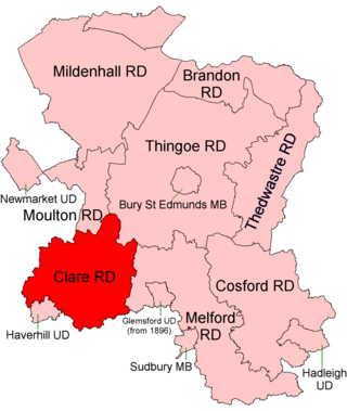
Clare Rural District was a rural district in the county of West Suffolk, England. It was created in 1894, comprising those parishes in the Risbridge rural sanitary district which were in Suffolk.

<span class="mw-page-title-main">Thingoe Rural District</span> Former rural district in West Suffolk, England

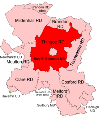
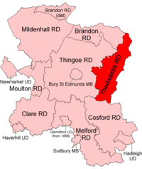
Thingoe Rural District was a rural district in the county of West Suffolk, England between 1894 and 1974. It was named after the ancient Hundred of Thingoe and administered from Bury St Edmunds, which it surrounded.

<span class="mw-page-title-main">Gipping Rural District</span>

Gipping Rural District was a rural district in the county of East Suffolk, England. It was created in 1934 by the merger of the disbanded Bosmere and Claydon Rural District and the disbanded East Stow Rural District, under a County Review Order. It was named after the River Gipping and administered from Needham Market.

<span class="mw-page-title-main">Hartismere Rural District</span> Rural district in East Suffolk, England

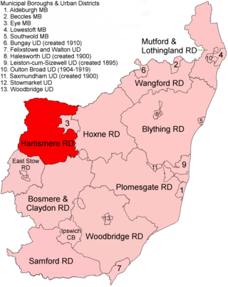
Hartismere Rural District was a rural district in the county of East Suffolk, England. It was expanded in 1934 by merging with the disbanded Hoxne Rural District with a slight readjustment of boundaries. It was named after the ancient Hundred of Hartismere and administered from Eye.

<span class="mw-page-title-main">Melford Rural District</span> Former rural district in West Suffolk, England

Melford Rural District was a rural district in the county of West Suffolk, England. It was created in 1894, under the Local Government Act 1894 from that part of the Sudbury rural sanitary district in West Suffolk. It was named after Long Melford and administered from Sudbury. Shortly after its creation, in 1896, the parish of Glemsford was made a separate urban district.

<span class="mw-page-title-main">Lothingland Rural District</span> Former rural district in East Suffolk, England

Lothingland was a rural district in East Suffolk, England, named after the ancient half-hundred of Lothingland which was merged with Mutford half-hundred in 1763 to form Mutford and Lothingland.

<span class="mw-page-title-main">Ely Rural District</span>

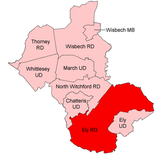
Ely Rural District was a rural district in England from 1894 to 1974. It was named after Ely, but did not include the city itself, instead covering the rural area to the west and north of it. It formed part of the administrative county of the Isle of Ely from 1894 to 1965, when this was merged into Cambridgeshire and Isle of Ely.

<span class="mw-page-title-main">East Stow Rural District</span>

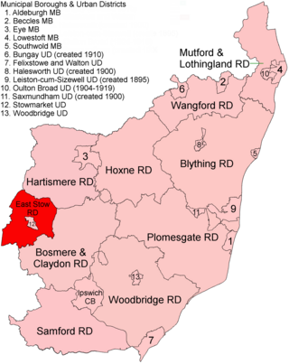
East Stow was a rural district in East Suffolk, England from 1894 to 1934.

<span class="mw-page-title-main">Deben Rural District</span> Rural district in East Suffolk, England

Deben Rural District was a rural district in the county of East Suffolk, England. It was created in 1934 by the merger of parts of the disbanded Bosmere and Claydon Rural District, the disbanded Plomesgate Rural District and the disbanded Woodbridge Rural District, under a County Review Order. It was named after the River Deben and administered from Woodbridge.

<span class="mw-page-title-main">Moulton Rural District</span> Former rural district in West Suffolk, England

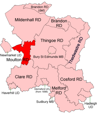
Moulton was a rural district in Suffolk, England from 1894 to 1935. It covered the area to the east of the town of Newmarket.

<span class="mw-page-title-main">Depwade Rural District</span>

Depwade Rural District was a rural district in Norfolk, England from 1894 to 1974.

<span class="mw-page-title-main">Brandon Rural District</span> Former rural district in Suffolk, England

Brandon was a rural district in Suffolk, England from 1894 to 1935. The district was created in 1894 as the Suffolk part of the Thetford rural sanitary district, the Norfolk part becoming Thetford Rural District. This left the westernmost parishes of Brandon and Santon Downham detached from the rest of the district.

<span class="mw-page-title-main">Blything Rural District</span>

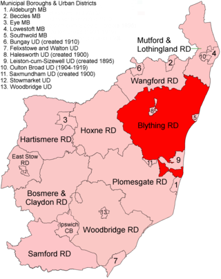
Blything Rural District was a rural district within the administrative county of East Suffolk between 1894 and 1934.

<span class="mw-page-title-main">Hoxne Rural District</span>

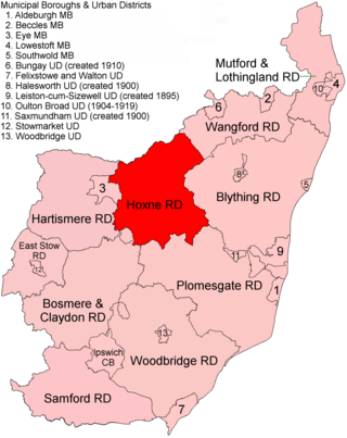
Hoxne Rural District was a rural district within the administrative county of East Suffolk between 1894 and 1934. It was created out of the earlier Hoxne rural sanitary district. It was named after the historic hundred of Hoxne, whose boundaries it closely matched. The hundred, in turn, took its name from the village of Hoxne.

<span class="mw-page-title-main">Mutford and Lothingland Rural District</span> Former rural district in West Suffolk, England

Mutford and Lothingland Rural District was a rural district within the administrative county of East Suffolk between 1894 and 1934. It was created out of the earlier Mutford and Lothingland rural sanitary district. It was named after the historic hundred of Mutford and Lothingland, whose boundaries it closely matched.

<span class="mw-page-title-main">Plomesgate Rural District</span> Former rural district in West Suffolk, England

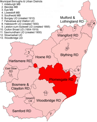
Plomesgate Rural District was a rural district within the administrative county of East Suffolk between 1894 and 1934.

<span class="mw-page-title-main">Wangford Rural District</span> Former rural district in East Suffolk, England

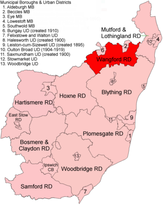
Wangford Rural District was a rural district within the administrative county of East Suffolk between 1894 and 1934. It was created out of the earlier Wangford rural sanitary district. It was named after the historic hundred of Wangford, whose boundaries it closely matched. It contained the group of small villages collectively known as The Saints.

<span class="mw-page-title-main">Blyth Rural District</span>

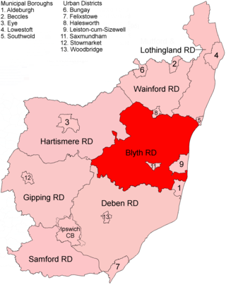
Blyth Rural District was a rural district in East Suffolk, England, between 1934 and 1974.

<span class="mw-page-title-main">Wainford Rural District</span> Former rural district in East Suffolk, England

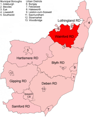
Wainford Rural District was a rural district in East Suffolk, England, between 1934 and 1974. It was created by a merger of the disbanded Wangford Rural District and parts of Blything Rural District, and contained the group of small villages collectively known as The Saints. The name Wainford is linked to that of Wangford, a historic hundred of Suffolk.

References

  1. "Thedwastre RD through time: Census tables with data for the Local Government District". A Vision of Britain through Time. GB Historical GIS / University of Portsmouth. Retrieved 8 July 2017.
  2. "Thedwastre RD through time | Census tables with data for the Local Government District". visionofbritain.org.uk. Retrieved 25 October 2020.
  3. "Thedwastre RD through time: Population Statistics: Area (acres)". A Vision of Britain through Time. GB Historical GIS / University of Portsmouth. Retrieved 8 July 2017.
  4. "Thedwastre RD through time: Population Statistics: Total Population". A Vision of Britain through Time. GB Historical GIS / University of Portsmouth. Retrieved 8 July 2017.
  5. "Local government meetings in the Stow Union". Bury Free Press. Bury St Edmunds. p. 8. Retrieved 5 April 2022.
  6. "Municipal Year Book and Public Utilities Directory". Municipal Journal: 1484. 1959. Retrieved 5 April 2022. Offices, 20a, Market Place, Stowmarket... Meeting, Council Offices, Stowmarket
  7. "Public Notices". Bury Free Press. Bury St Edmunds. p. 13. Retrieved 5 April 2022. ...at the offices of the Thedwastre Rural District Council at Elmswell...
  8. "Manns Court". EAC Housing Care. Retrieved 5 April 2022.
52°14′N0°53′E / 52.24°N 0.89°E / 52.24; 0.89