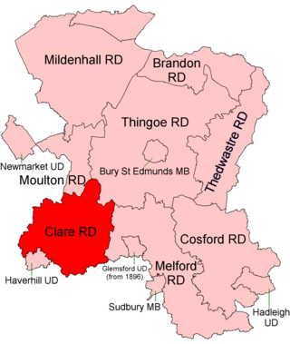
Clare Rural District was a rural district in the county of West Suffolk, England. It was created in 1894, comprising those parishes in the Risbridge rural sanitary district which were in Suffolk.
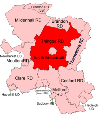
Thingoe Rural District was a rural district in the county of West Suffolk, England. It was created in 1894. On 1 April 1935 the parish of Depden was transferred to the Clare Rural District. On the same date the district was enlarged by the transfer of the civil parishes of Barnham, Barningham, Coney Weston, Euston, Fakenham Magna, Hepworth, Honington, Hopton, Knettishall, Market Weston, Sapiston, and Thelnetham from the disbanded Brandon Rural District.

Melford Rural District was a rural district in the county of West Suffolk, England. It was created in 1894, under the Local Government Act 1894 from that part of the Sudbury rural sanitary district in West Suffolk. It was named after Long Melford and administered from Sudbury. Shortly after its creation, in 1896, the parish of Glemsford was made a separate urban district.
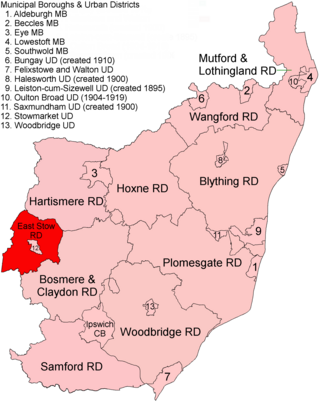
East Stow was a rural district in East Suffolk, England from 1894 to 1934.

Downham Rural District was a rural district in Norfolk, England from 1894 to 1974.
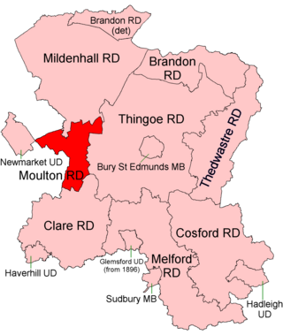
Moulton was a rural district in Suffolk, England from 1894 to 1935. It covered the area to the east of the town of Newmarket.

Swaffham Rural District was a rural district in Norfolk, England from 1894 to 1974.
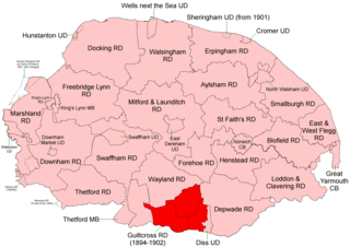
Wayland Rural District was a rural district in Norfolk, England from 1894 to 1974.

Thetford Rural District was a rural district in Norfolk, England from 1894 to 1935.

Depwade Rural District was a rural district in Norfolk, England from 1894 to 1974.

St Faith's and Aylsham Rural Districts were adjacent rural districts in Norfolk, England from 1894 to 1935.

Blofield and East and West Flegg Rural Districts were adjacent rural districts in Norfolk, England from 1894 to 1935.

Forehoe and Henstead Rural Districts were adjacent rural districts in Norfolk, England from 1894 to 1935.
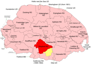
Guiltcross Rural District was a rural district in Norfolk, England from 1894 to 1902.

Cosford Rural District was a rural district in the county of West Suffolk, England. It was created in 1894 out of the earlier Cosford rural sanitary district, except for Hadleigh parish which was made a separate urban district. Only minor adjustments were made to its boundary in the reorganisation of 1935. It was named after the historic hundred of Cosford, although the rural district covered a significantly larger area that included most of Cosford hundred and part of the neighbouring hundred of Babergh.

Mildenhall Rural District was a rural district in the county of West Suffolk, England. It was created in 1894 out of the former Mildenhall rural sanitary district.
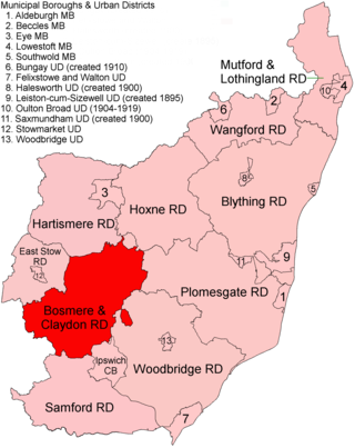
Bosmere and Claydon Rural District was a rural district within the administrative county of East Suffolk between 1894 and 1934. It was created out of the earlier Bosmere and Claydon rural sanitary district. It was named after the historic hundred of Bosmere and Claydon, although the rural district covered a significantly larger area than the hundred.

Mutford and Lothingland Rural District was a rural district within the administrative county of East Suffolk between 1894 and 1934. It was created out of the earlier Mutford and Lothingland rural sanitary district. It was named after the historic hundred of Mutford and Lothingland, whose boundaries it closely matched.
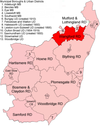
Wangford Rural District was a rural district within the administrative county of East Suffolk between 1894 and 1934. It was created out of the earlier Wangford rural sanitary district. It was named after the historic hundred of Wangford, whose boundaries it closely matched. It contained the group of small villages collectively known as The Saints.
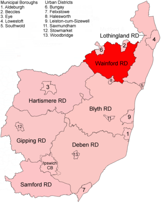
Wainford Rural District was a rural district in East Suffolk, England, between 1934 and 1974. It was created by a merger of the disbanded Wangford Rural District and parts of Blything Rural District, and contained the group of small villages collectively known as The Saints. The name Wainford is linked to that of Wangford, a historic hundred of Suffolk.
