Thetford Rural District

Last updated
Position within Norfolk, 1894 Thetford RD 1894.png
Position within Norfolk, 1894

Boundaries in 1894. 1902 extension in yellow

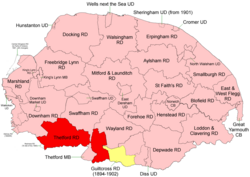
Thetford Rural District was a rural district in Norfolk, England from 1894 to 1935. [1]

Contents

It was formed under the Local Government Act 1894 based on the Thetford rural sanitary district. It covered the lands which were in Norfolk and lay to the north and east of Thetford Municipal Borough.

In 1902 it took in the western part of the disbanded Guiltcross Rural District, [2] .

In 1935, Thetford RD was abolished and its territory divided between Downham, Swaffham and Wayland RDs.

Statistics

YearArea (ha)
[3]
Population
[4]
Density
(pop/ha)
191138,79914,4250.37
192113,1210.34
193113,1500.34

Parishes

ParishFromToNotes
Blo' Norton 1902Formerly Guiltcross RD. To Wayland RD
Brandon 1902Formerly Guiltcross RD. To Wayland RD
Brettenham To Wayland RD
Bridgham 1902Formerly Guiltcross RD. To Wayland RD
Cranwich To Swaffham RD
Croxton To Wayland RD
East Harling 1902Formerly Guiltcross RD.
East Wretham 1902To Wayland RD
Feltwell To Downham RD
Feltwell Anchor 1929Added to Feltwell
Garboldisham 1902Formerly Guiltcross RD. To Wayland RD
Gasthorpe 1902Formerly Guiltcross RD.
Great and Little Snarehill To Wayland RD (with Brettenham)
Hockwold cum Wilton To Downham RD
Kilverstone To Wayland RD
Lynford To Swaffham RD
Methwold To Downham RD
Mundford To Swaffham RD
North Lopham 1902Formerly Guiltcross RD. To Wayland RD
Northwold To Downham RD
Riddlesworth 1902Formerly Guiltcross RD. To Wayland RD
Rushford To Wayland RD (with Brettenham)
Santon To Swaffham RD
South Lopham 1902Formerly Guiltcross RD. To Wayland RD
Sturston To Swaffham RD
Weeting with Broomhill To Swaffham RD
West Harling 1902Formerly Guiltcross RD.
West Tofts To Swaffham RD
West Wretham To Wayland RD

Related Research Articles

Clare Rural District

Clare Rural District was a rural district in the county of West Suffolk, England. It was created in 1894, comprising those parishes in the Risbridge rural sanitary district which were in Suffolk.

Melford Rural District

Melford Rural District was a rural district in the county of West Suffolk, England. It was created in 1894, under the Local Government Act 1894 from that part of the Sudbury rural sanitary district in West Suffolk. It was named after Long Melford and administered from Sudbury. Shortly after its creation, in 1896, the parish of Glemsford was made a separate urban district.

Ely Rural District

Ely was a rural district in England from 1894 to 1974. It was named after Ely, and surrounded it to the west and north. The district was created in 1894 under the Local Government Act 1894 from the Ely rural sanitary district. It formed part of the administrative county of the Isle of Ely from 1894 to 1965, when this was merged into Cambridgeshire and Isle of Ely.

Walsingham Rural District

Walsingham Rural District was a rural district in the county of Norfolk, England. It was created in 1894. On 1 April 1935 it was enlarged by the addition of the parishes of Hindolveston, Thurning, Wood Norton and Briston. On 1 April 1974 it was abolished under the Local Government Act 1972, and has since formed part of the District of North Norfolk.

Downham Rural District

Downham Rural District was a rural district in Norfolk, England from 1894 to 1974.

Marshland Rural District

Marshland Rural District was a rural district in Norfolk, England from 1894 to 1974.

Moulton Rural District

Moulton was a rural district in Suffolk, England from 1894 to 1935. It covered the area to the east of the town of Newmarket.

Swaffham Rural District

Swaffham Rural District was a rural district in Norfolk, England from 1894 to 1974.

Wayland Rural District

Wayland Rural District was a rural district in Norfolk, England from 1894 to 1974.

Depwade Rural District

Depwade Rural District was a rural district in Norfolk, England from 1894 to 1974.

Mitford and Launditch Rural District

Mitford and Launditch Rural District was a rural district in Norfolk, England from 1894 to 1974.

Erpingham Rural District

Erpingham Rural District was a rural district in Norfolk, England from 1894 to 1974.

Smallburgh Rural District

Smallburgh Rural District was a rural district in Norfolk, England from 1894 to 1974.

Loddon and Clavering Rural District

Loddon and Clavering Rural District was a rural district in Norfolk, England from 1894 to 1935., continuing, with very slight boundary changes, as Loddon Rural District until 1974.

St Faiths and Aylsham Rural District

St Faith's and Aylsham Rural Districts were adjacent rural districts in Norfolk, England from 1894 to 1935.

Blofield and Flegg Rural District

Blofield and East and West Flegg Rural Districts were adjacent rural districts in Norfolk, England from 1894 to 1935.

Forehoe and Henstead Rural District

Forehoe and Henstead Rural Districts were adjacent rural districts in Norfolk, England from 1894 to 1935.

Guiltcross Rural District

Guiltcross Rural District was a rural district in Norfolk, England from 1894 to 1902.

Brandon Rural District

Brandon was a rural district in Suffolk, England from 1894 to 1935. The district was created in 1894 as the Suffolk part of the Thetford rural sanitary district, the Norfolk part becoming Thetford Rural District. This left the westernmost parishes of Brandon and Santon Downham detached from the rest of the district.

Mutford and Lothingland Rural District

Mutford and Lothingland Rural District was a rural district within the administrative county of East Suffolk between 1894 and 1934. It was created out of the earlier Mutford and Lothingland rural sanitary district. It was named after the historic hundred of Mutford and Lothingland, whose boundaries it closely matched.

References

  1. "Thetford RD through time: Census tables with data for the Local Government District". A Vision of Britain through Time. GB Historical GIS / University of Portsmouth. Retrieved 29 June 2017.
  2. "Garboldisham CP/AP through time: Census tables with data for the Parish-level Unit". A Vision of Britain through Time. GB Historical GIS / University of Portsmouth. This change is not reported on the District level pages, but is apparent from parish commencement dates. Retrieved 29 June 2017.
  3. "Thetford RD through time: Population Statistics: Area (acres)". A Vision of Britain through Time. GB Historical GIS / University of Portsmouth. Retrieved 29 June 2017.
  4. "Thetford RD through time: Population Statistics: Total Population". A Vision of Britain through Time. GB Historical GIS / University of Portsmouth. Retrieved 29 June 2017.

Coordinates: 52°29′N0°40′E / 52.48°N 0.67°E / 52.48; 0.67